Viewing entries tagged
Grand Canyon

Catastrophic formation of the Grand Canyon: still more evidence, this time from the Mojave Desert


If Dr. Walt Brown's hydroplate theory is correct, and the Grand Canyon is a result of the rapid release of millions of tons of water that had been trapped in two massive inland seas (Grand Lake and Hopi Lake, shown in the image on this page of the online version of his book), then the release of so much water should have left evidence all the way along its path to the ocean.  The evidence of such an event would look very different than the evidence that we would find if the Grand Canyon was carved slowly over tens of millions of years by the action of the Colorado River (the conventional explanation).  

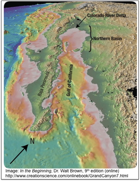
The previous discussion presented just that kind of evidence, in the form of six thousand cubic miles of sediments along the northern basin of the Gulf of California.  However, diving down to the floor of the Gulf of California is not an easy undertaking.  Fortunately, we should expect to find plenty more evidence in between the Grand Canyon and the Gulf of California which could provide clues as to the mechanism behind the Canyon's formation -- evidence that would look very different depending on whether its formation was caused by massive amounts of water moving at very high velocity after huge lakes breached, or whether its formation was instead caused by a relatively small river moving at normal speeds over millions of years.

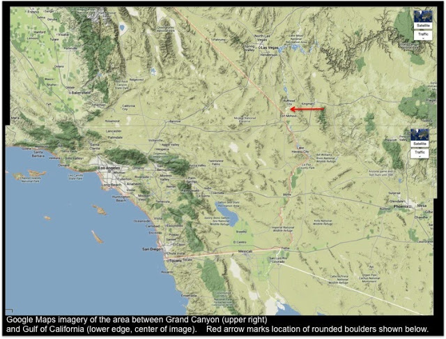
The image above, from Google Maps, shows the distinctive terrain between the two features (Grand Canyon and Gulf of California), a desert region resembling a vast flood plain, marked by ridge line features that resemble lines of dirt left over by a drainage event.  This area is part of the larger "Great Basin" region, and contains the Mojave Desert.  If you can imagine lining the bottom of a bathtub with dirt, then filling it up with water, and then blowing a hole in the side of the bathtub with a large firecracker (like an M-80) [don't try this at home -- this is only a thought experiment], you might be left with a similar pattern of dirt "eddies" along the floor of the bathroom after all the water flowed out of the tub and out of the bathroom (assuming the water had someplace lower to run towards).

If you explore the terrain shown above in person (and I have spent quite a bit of time crawling around in the regions shown in the map) you will find that it is full of very interesting terrain, and that most of the ridge line features that rise up out of the desert are full of a mix of rocks and boulders of all sizes and shapes.  Some of these have been rounded into spheroid shapes by some process.  According to Dr. Brown's interpretation of this evidence, these provide further support for the hypothesis that the Grand Canyon was the product of massive volumes of high-velocity water, which removed thousands of cubic miles of sediments and flowed towards the Gulf of California like a massive tsunami.  

In figure 136, which is found on this page of Dr. Brown's chapter on the Grand Canyon (under paragraph 13, "Missing Dirt"), he presents a photograph of two such spheroid boulders, located south of Bullhead City, Arizona about a mile east of the Colorado River and a hundred feet in elevation above that river (see image below).  The approximate location of this photograph is marked in the map above with a red arrow.  


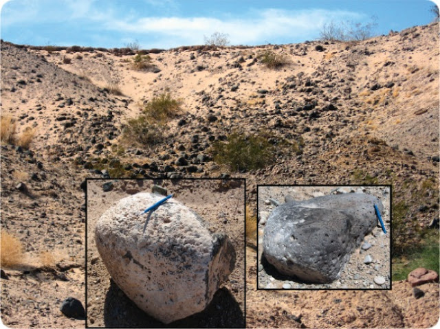
What could have rounded these boulders into their smooth shapes?  One possibility is the action of high-velocity water, moving them along the bottom for miles at a rapid pace, and depositing them far from the present river and at an elevation high above it.

These boulders shown in Dr. Brown's book (the same image can be seen in the hardcopy version of his book, on page 205 of the 8th edition) are by no means anomalous to the region.  Other similarly rounded boulders can be seen in the Coachella Valley, far to the west and south of the red arrow in the image above, but still in the area that would have been flooded by the rapidly-moving water from the breaching of Grand and Hopi Lakes, if the hydroplate theory is correct.  See for example the photograph at the top of this page (linked) showing very spheroid boulders, some piled on top of one another with large gaps in between them.

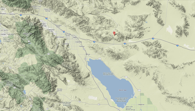
There are a few possibilities for explaining the boulders in that image, which are located in Joshua Tree National Park at the approximate location of the marker (the red marker, with the letter "A" on it) in the image below:


That location can be found on the map at the top of this post as well -- it is just north of the Salton Sea and Interstate 10 (you can find the Salton Sea on the map at the top of this post -- it is about center from the left and right sides of the image, but closer to the lower edge of the image).

Those boulders could have been carved into spheroid shapes by the wind, although this explanation seems somewhat unlikely (especially as they are piled on top of one another -- the wind would not be expected to deposit large boulders on top of one another in that manner).  They could have been ejected from an ancient volcano in this spheroid shape and left in a pile as shown in the photograph (while this possibility does not seem to be the correct one, especially given the composition of the rocks themselves, it is a possible explanation).  Or, they could have been eroded into a spheroid shape by rolling for miles at the bottom of a huge flow of water, and left in the location we find them today by that water as it coursed down through the maze of mountainous terrain features towards the Gulf of California.

In his discussion of the evidence (again from paragraph 13 on this page of his online book), Dr. Brown writes:

At least 2,000 cubic miles of Mesozoic sediments were stripped off the layers surrounding and above what is now the Grand Canyon. Only then could the 800 cubic miles of sediments be removed from inside the Grand Canyon. All that dirt was spread downstream from the Grand Canyon, primarily into the northernmost 220 miles of the Gulf of California.
Relatively few sediments were deposited along the Colorado River as it flows south toward the Gulf of California. Rounded boulders mixed with sand and clay are often seen where today’s side streams have cut channels 100–200 feet deep. Those rounded boulders show that they were tumbled and transported by high-velocity water. Unsorted mixtures of sand, clay, and boulders show that the turbulent, muddy water suddenly slowed, depositing the unsorted mixture. [See Figures 136 and 137.]

Clearly, if the Canyon were carved by the normal action of the Colorado River over millions of years, we would have to find another explanation for the location and condition of these boulders.  It would be difficult (if not impossible) to explain this evidence by saying that the river has been flowing at a fairly uniform rate and volume for millions of years.

If you read further in paragraph 13 on the web page cited above from Dr. Brown's book, you will find a reference to a recent (2011) study of the very area under discussion, which looked at the geology of the area shown in the map above and said that although the sediments in the area in question have been widely studied for over a hundred fifty years, "their origin remains unresolved and their stratigraphic context has been confused" (Stratigraphy and Depositional Environments of the Upper Pleistocene Chemehuevi Formation along the Lower Colorado River, Malmon, Howard, House, Lundstrom, Pearthree, Sarna-Wojcicki, Wan and Wahl, 2012 -- link to full report).

They offer a new theory for the origin of the sediments in the vast flood plain between the Grand Canyon and the Gulf of California, namely "a single major episode of fluvial aggradation, during which the Colorado River filled its valley with a great volume of dominantly sand-sized sediment."

While it is nice to see conventional geologists arguing for an extraordinary event to explain evidence that clearly calls for such an explanation (and note that their study was published long after Dr. Brown wrote the discussion quoted above, which can be found in his 2008 hard-copy 8th edition, minus the reference to the 2011 study), their explanation still fails to explain the rounded boulders shown in the two locations discussed above.  A flooding river might move large rocks, but it would not be expected to have the velocity to roll them along for miles at high speeds and round them into spheroids, nor would it be able to pile them up in the jumble shown in the Joshua Tree image.

In short, the evidence on the ground in between the Grand Canyon and the Gulf of California appears to support the hydroplate theory, and to refute the conventional explanations.  And that is in addition to the tons of sediments at the bottom of the Gulf of California (which suggest a rapid high-volume dumping, because if those sediments were deposited by a river over millions of years, it would have been expected to build up a large river delta, which is not present at the north end of the Gulf, as discussed in the previous post and in Dr. Brown's books).

All of this evidence can be added to the massive amounts of evidence in the vicinity of the Grand Canyon itself, which suggests that this incredible terrain feature is the product of a catastrophic event involving huge volumes of high-velocity water, and not the action of a normal river moving with normal volumes and normal velocities over the course of millions of years.  And yet teachers in school responsible for the education of children from the youngest grades through graduate school, as well as all the guides at the Grand Canyon itself, continue to insist on presenting the conventional theory as if it were settled fact, and as if anyone suggesting an alternative explanation is way out of bounds.

Missing dirt from the Grand Canyon found on the floor of the Gulf of California!


The Grand Canyon is often included on lists of the "Seven Wonders of the Natural World" (following on the tradition of creating lists of the "Seven Wonders of the World," a tradition which started in antiquity).  It is truly one of the most massive canyons on earth, stretching well over 200 miles, over the course of which its widths span from four to an incredible eighteen miles across, and reaching an average depth of a mile from the rim to the riverbed far below.

The amount of earth that had to be removed to form such an enormous abyss is truly staggering.  The US National Park Service web page lists the volume of the Grand Canyon as 5.45 trillion cubic yards.  This is an almost-inconceivable volume of dirt that had to be removed.  

Where did it all go?

Walt Brown, the originator of the hydroplate theory, who devotes an entire chapter of his book (available online and in print) to the Grand Canyon, recognizes the significance of this question.  He notes that the volume of sediments that had to be displaced totals about 800 cubic miles!  

He also explains that most conventional theories for the formation of the Grand Canyon, such as the idea that the Colorado River slowly eroded this massive canyon (averaging ten miles wide and one mile deep for well over 200 miles) have a real problem explaining where all that dirt went.

The Colorado River empties into the Gulf of California (the body of water between the Baja peninsula), and Mexico itself.  If that dirt was gradually eroded, there should be a massive delta where the river meets the gulf, but the delta there is tiny, containing not even 1% of the volume of dirt that must at one time have been removed from the Grand Canyon (see for instance point 20 on this web page from Dr. Brown's book).

Dr. Brown relates the story of one of the Grand Canyon's most colorful characters from the end of the nineteenth and early twentieth centuries, John Hance (known as "Captain" John Hance, or sometimes "Cap").  He became famous for regaling visitors with his tall tales, including his explanation of how the mighty canyon came into being.  Quoting a description of Captain Hance's famous account of the canyon's origin, given by former Arizona governor and former US Secretary of the Interior Bruce Babbitt, Dr. Brown relates:
Children loved John Hance, and to them he always explained how the canyon came into being.  "I dug it," he would say simply.  This story worked well for years until one little four-year old girl asked seriously, "And where did you put all the dirt?"  Hance had no ready answer; he never used that story again.  But it bothered him the rest of his life, and when he was dying he whispered to his waiting friends, "Where do you suppose I could have put that dirt?" (from this page in Dr. Brown's online book, quoting Bruce Babbitt -- see footnote 4. on this page).
For more of John Hance's deadpan tall-tales, see this description of the colorful Grand Canyon guide.  Apparently, the question of where all that dirt went made a deep impression on Captain Hance, and troubled him to the end of his days.  It is a question that conventional geologists have yet to answer.

However, the hydroplate theory of Dr. Brown provides an answer for the question of where all those cubic miles of dirt ended up.  As related in previous posts, and discussed in greater detail in his book, Dr. Brown's hydroplate theory argues that the Grand Canyon was not carved by the mechanism of slow erosion by the Colorado River over millions of years, but rather that it was created in a relatively short period of weeks or months by the catastrophic breaching of two enormous inland seas, each one of which were left over from a world-wide flood.  Previous posts pointing to evidence that makes the conventional theory difficult to accept but which support Walt Brown's theory for the formation of the Grand Canyon include:
If the Grand Canyon is a product of a massive, high-volume and high-intensity outpouring of millions of tons of water from two huge inland seas left over from the world-wide flood (you can see where Dr. Brown believes these two huge water bodies once stood on this map in his online book), then the final resting place for all that dirt would be very different than if the dirt were removed gradually over millions of years by a relatively small river.

In fact, the sudden breaching of two enormous water bodies of the size described by the hyrdoplate theory would have removed even more dirt than was in the Grand Canyon, as massive as that is.  According to the hydroplate theory, the breaching of these two inland seas removed at least 2,000 cubic miles of sediments above what is now the Grand Canyon, in addition to the 800 cubic miles of sediment that had to come out of the canyon itself.  You can read in his book how the removal of all that sediment caused the layers below to arch upwards, a phenomenon whose evidence is clearly visible in the geology of the region of the Grand Canyon, and in places to crack (Marble Canyon was caused by this upward arching and subsequent cracking motion).

All those cubic miles of sediments were washed away by the violent release of the two huge lakes, and they swept along until they dumped into the sea -- in this case, they dumped into the Gulf of California, where the Colorado River still meets the sea today.  Along the way, many sediments were deposited into the region between the Grand Canyon and the Gulf of California, but a huge quantity of them dumped into the gulf and they are still there today.

The image below, from Dr. Brown's book here (see section 13, "Missing Dirt"), contains modern three-dimensional imagery of the Gulf of California showing where all those sediments ended up.  Dr. Brown's caption for the image reads in part as follows:
Here's the Dirt.  It's right where we would expect it, if we understood the Grand Canyon's rapid and violent formation.  Hidden beneath the flat floor of the Gulf of California are at least 6,000 cubic miles of sediments.  That basin, bounded on the south by the largest islands in the Gulf, has an area of 15,000 square miles (220 miles long and 60-100 miles wide).  Sediment depths are up to 1.2 miles thick!  About half the basin's sediments were rapidly transported from the Grand Canyon (on the figure's northern horizon), along the path now occupied by the Colorado River.
Why is the Northern Basin's 15,000-square-mile floor so flat?  Within weeks, a few thousand cubic miles of sediments were swept into the basin.  The larger particles settled out first, near today's shoreline.  Finer particles settled out last, but until they did, the muddy water, because it was denser, flowed to the basin's deeper regions where the mud eventually settled, flattening the seafloor.
You can see water depths for the various parts of the Gulf of California in this 1956 study of the feature, "Oceanographic and Meteorological Aspects of the Gulf of California," by Gunnar I. Roden.  The excellent bathymetry charts on pages 22 and 23 of that study clearly show that while the northern portion of the gulf (where Dr. Brown's theory says the sediments were dumped) has depths below 200 meters, the rest of the gulf reaches depths of over 2,800 meters!  In other words, if Dr. Brown is correct -- and the evidence from the Gulf of California seems to support his argument -- then the depths of those sediments are truly astonishing.

This evidence is just one more of many pieces of evidence surrounding the formation of the Grand Canyon which appears to refute the conventional explanations and support the explanation put forward in Dr. Brown's hydroplate theory.  The evidence for the hydroplane theory from the Grand Canyon alone is extremely compelling, but that is just one geological feature among literally several hundred more that Dr. Brown examines in his book, all of which contain evidence which appears to support his theory.

Based on all this evidence, the conventional theories seem about as plausible as Captain John Hance's wry explanation for the origin of the Grand Canyon.  Or, to say it another way, Captain Hance's explanation appears just as good as the stories that park rangers tell visitors to this day regarding the origin of this "natural wonder of the world."  (But where did he put all that dirt?)


The geology of the Little Colorado River Gorge


Over the weekend, on Sunday 06/23, aerialist Nik Wallenda crossed the Little Colorado River Gorge on a two-inch-wide steel cable, taking approximately 22 minutes to make the journey.

Many watched the event live on the Discovery Channel, which sponsored the c
rossing.  Some of the footage can be seen here at the Discovery Channel website.

Some Native tribes protested the event, arguing that the canyon is sacred to their people and should not be used for a publicity stunt.  Others assisted in the event, and the Navajo Nation provided the permit in exchange for the clean up of some platforms and cables left behind for decades after a planned crossing in the 1970s that never took place due to lack of funding (according to this article).

Whatever your opinion of that controversy, Wallenda successfully accomplished the incredible crossing over the 1,500-foot chasm.  The geology of the location is absolutely breathtaking.  It also provides important clues about our planet's past.

Below is a map showing the location of the Little Colorado River Gorge.  It empties into an area of unusual erosion called Nankoweap Canyon, near the point where it comes together with the Colorado River.  This junction of the the Colorado and Little Colorado is called the Confluence and is sacred to the Native tribes of the area as the site of the most ancient inhabitants of the region.


Both Nankoweap Canyon and the Little Colorado River Gorge are important clues to the mystery of the formation of the Grand Canyon, and they present geological evidence that confounds conventional theories.

Dr. Walt Brown, the originator of the hydroplate theory, believes the Grand Canyon was formed by events that took place in the aftermath of a global flood, and his theory provides an explanation for the Little Colorado River and Nankoweap Canyon (as well as for the very difficult-to-explain turn in the Colorado River seen in the map above, where the river that was running generally north-to-south takes a hard right turn to the west and plows right through the enormous massif of the Kaibab Plateau, which is colored green in the map).

Previous posts have detailed Dr. Brown's theory for the creation of the Grand Canyon -- see for example:
n and surrounds, see for example:
Dr. Brown believes that the mechanisms that formed the Grand Canyon and surrounding features began with two large bodies of water that were trapped after the floodwaters drained off the earth, and uplifted by the physics related to the rapid formation of the Rocky Mountains, whose weight caused them to sink downwards, forcing the Colorado Plateau upwards.  

Dr. Brown calls these two lakes "Grand Lake" (further north) and "Hopi Lake" (further south), and diagrams where they were on this map. He believes that Grand Lake eventually breached catastrophically due to increased rainfall and runoff after the flood (caused by warmer oceans). The tons of water cascading out of it eventually undermined the walls holding in Hopi Lake as well, and it breached as well.  The Little Colorado River Gorge marks the location of the breach of Hopi Lake.

About halfway down this webpage, Dr. Brown discusses Nankoweap Canyon and the evidence there which is very difficult to explain by proponents of the conventional theory for the Grand Canyon's formation.  Discussing the detailed image of the Nankoweap Canyon region shown there, he writes:
Nankoweap—Region of Unusual Erosion. This view is looking southeast from 4,400 feet above the ground. The Little Colorado River enters the southern end of Marble Canyon at the top center. The yellow line encloses a region of unusual erosion. Notice that on the top of the high Kaibab Plateau, streams do not flow into the many canyons that are cut into this southeastern portion of the Kaibab Plateau. So, what cut these side canyons, and why are they in such a localized area? Why would the terrain east of Marble Canyon, which is at least 2,000 feet below the top of the Kaibab Plateau and most of this erosion, be so smooth? On top of Nankoweap Mesa are slumps, landslides, and rockfalls. How can rocks fall and mud flow onto the top of a mesa?  
Another point of difficulty for conventional theorists is the origin of the Little Colorado Gorge in the first place.  As you can see from the map above, it seems to spring from out of the desert itself.  Dr. Brown's theory argues that subsurface water burst out of the water table after Grand Lake and Hopi Lake began to empty, and it was this subsurface water which was responsible for creating many of the major canyons that we see emptying into the Grand Canyon from the sides.  The canyons themselves, such as Marble Canyon and the Little River Gorge, are cracks created when the ground arched upwards after the catastrophic breaching of Grand Lake and Hopi Lake removed the material above.  The subsurface water then flowed out the sides of these cracks, creating the side canyons we see today, including the Little Colorado Gorge.

The fact that Nankoweap Canyon was the site of the earliest known habitation in the area is also problematic for conventional geological theories, because they have a hard time explaining where all the water came from that attracted the Old Ones or Anasazi to the area in the first place, and what caused it to disappear, causing them to leave.  This article by Terry Hurlbut discusses this question, and interestingly enough does so in light of Dr. Brown's theory, which provides a satisfactory explanation for the human history of the area.

We can all be glad that Nik Wallenda made it safely across the canyon on his first try.  His feat should cause us to examine the amazing geology of the Little Colorado River Gorge and the Grand Canyon, as well as to reflect upon the sacred traditions of the Native tribes who still remember and honor their ancestors who lived in the region so long ago -- and to consider the ways in which the geology and the human history of this beautiful area are intertwined. 


The bizarre "barbed tributaries" of Marble Canyon


Above is a beautiful image taken from the platform of the space shuttle Discovery in 1985, showing the Grand Canyon in November (south is at the top of this image, and north is at the bottom).  This image is not only breathtaking, but also clearly reveals many of the important pieces of geological evidence about the Grand Canyon which support a catastrophic mechanism for its creation, as opposed to the uniformitarian explanations which are commonly foisted upon the public.

Specifically, these pieces of evidence are features which Dr. Walt Brown discusses in the chapter of his book in which he discusses the Grand Canyon and the facts there which support his hydroplate theory, a theory which proposes that almost all of the geological features of our planet were shaped in the events surrounding a catastrophic global flood.  In that chapter, he proposes that the Grand Canyon was formed when waters trapped after the flood in two huge lakes (which he names "Grand Lake" and "Hopi Lake") breached and poured out with tremendous violence, carving the awe-inspiring wonder of the world that we know today.

Some of the evidence which can be seen in the NASA image which refute the standard explanation that the Colorado River gradually carved out the Grand Canyon over millions of years include the Colorado River's dramatic "right turn" in which it plows right through the massif of the Kaibab Plateau (which is labeled in the image below), as well as the many mysterious canyons that lead into the path that the Colorado River takes but which seem to have no perceptible source.  

Previous posts have discussed the formation of the Grand Canyon and the way that Dr. Brown's theory can explain the path right through the Kaibab Plateau (while conventional theories have great difficulty explaining this geological fact).  To revisit some of the previous discussion of the Grand Canyon and surrounds, see for example:
Let's now examine these mysterious side canyons, which this superb space shuttle image make so easy to see, in a bit more detail.

In a section entitled "Side Canyons" on this page of his online book in the chapter on the Grand Canyon, Dr. Brown explains some of the enigmatic features of these side canyons which make them very difficult to account for if using conventional uniformitarian theories of gradual erosion by the Colorado River:
Dozens of large side canyons intersect the main trunk of Grand and Marble Canyons and cut down to the level of the Colorado River. These side canyons also have their own side canyons, all connected like branches on a big, bushy tree. Surprisingly, most side canyons, at least today, have no source of water that could have carved them—or basins above that could have held much water.  
Even more difficult to explain is the direction of some of these side canyons, which some geologists call "barbed" canyons, because they come into the main river path from what would seem to be the "wrong direction."  Dr. Brown writes:
A few side canyons are “barbed.” That is, they connect to the main canyon “backwards,” similar to the barbs in barbed wire or fishhooks. Tributaries almost always enter rivers at acute angles, but the barbed canyons are oriented at obtuse angles. Very strange.15 What happened? 
The footnote is to a description from a book by geologist, trail guide and author Wayne Ranney, entitled Carving Grand Canyon:  Evidence, Theory, and Mysteries, in which Mr. Ranney writes:
Additionally, in Marble Canyon, many tributary streams come into the Colorado River flowing generally to the north, against the southerly flow of the modern river. This creates a pattern of drainage known to geologists as "barbed" tributaries. The Marble Platform, into which the tributaries have been carved, also slopes down to the northeast exactly opposite the flow direction of the modern river.  23.
The image below (same NASA image, with additional markings and labels) points out a two of these barbed canyons.  Note that they are intersecting the main channel of the Colorado from south to north, even though the Colorado River is flowing from north to south:


Strictly speaking, as noted in Mr. Ranney's quotation above, these barbed canyons are found in the portion of the overall canyon complex known as Marble Canyon, which is the name given to the canyon section between Lee's Ferry and the point where the Little Colorado River comes into the path of the Colorado River (see map below):


Note, of course, that unlike the previous two images, this map is oriented with north at the top rather than at the bottom.  The barbed canyons along the path of Marble Canyon are clearly visible, especially along the section of Marble Canyon just south of the arrow indicating the location of Lee's Ferry.

So, what could account for these strange barbed canyons, which appear from no apparent source and enter the Colorado River and the main channel of the canyon from a generally south-to-north angle instead of coming in the same way that the river flows, namely north-to-south?  

The standard uniformitarian answer involves, of course, long periods of time, and posits that drainage plain between the Kaibab Plateau and the canyon allowed the runoff from occasional thunderstorms to gather itself together into channels that flowed from south-to-north, and that the drainage plain on the other side, between the canyon and the Vermillion and Echo Cliffs, did the same thing.  The Vermillion and Echo Cliffs are the line of cliffs through which the tell-tale "funnel" feature can be seen to erupt -- Lee's Ferry is right in the middle of this funnel.

This uniformitarian explanation relies on the idea that the line of the Vermillion and Echo Cliffs slowly retreats to the northeast, due to erosion, while the hump of the Kaibab Plateau remains anchored in place.  This northward retreat causes the water to run generally from the higher ground in the direction of the Kaibab towards the lower ground in the direction of the retreating cliffs -- thus, the runoff from the annual wet season goes towards the north.  

That is certainly one possible explanation.  Readers should examine the evidence closely and see whether it fits what is seen "on the ground," and whether does a better job than other theories at explaining the features in the area, including the cliffs, the funnel, Marble Canyon itself, and the deep barbed canyons running into it from the south on either side.  

This and other competing explanations should be compared against the detailed explanation offered by Dr. Brown in his book -- one aspect of his book that I think is very laudable is Dr. Brown's comparison of competing explanations, which he tries to present as fairly as possible.  He then points out evidence that each theory (including his own) has difficulty explaining, and evidence that each theory explains well.

This webpage from Dr. Brown's online book gives a detailed explanation, with terrific photographs, of the geology of Marble Canyon, and the forces that he believes created its incredible features, including the barbed canyons.  

He explains that the Vermillion and Echo Cliffs were originally joined in one long cliff-line, which was uplifted as a reaction to the sinking down of the newly-formed Rocky Mountains further west (the Rockies having been created by the violent buckling of the hydroplates that had been sliding away from the rupture in the earth's crust that started the flood to begin with -- this previous post explains why the principles of physics tell us that the creation of huge mountain ranges such as the Rockies require more force than the tectonic theory can muster).  

The huge lakes trapped on this uplifted Colorado Plateau during the recovery phase after the flood (after the floodwaters drained into the ocean basins -- creating huge submarine canyons still visible today and difficult to explain by uniformitarian theories) eventually breached, starting with the northern of the two lakes, a breach which created the huge funnel clearly visible in the map above in the middle of which is Lee's Ferry.  This breaching water did not carve Marble Canyon; rather, it blasted away all the soft sedimentary layers (the ones that uniformitarians call the "mesozoic" layers) in the path of the funnel, stripping away down to the harder and more brittle limestone below.

Dr. Brown explains:
Suddenly, Grand Lake breaches a point on its bank and catastrophically erodes the soft Mesozoic sediments, forming a gigantic spillway—a steep, 18-mile-long channel shaped like a widening funnel. The escaping water’s large volume and high velocity erodes the far end of the funnel within weeks to a width of 12 miles and a depth of 2,000 feet.

Marble Canyon. The originally horizontal sedimentary layers below the floor of the funnel steadily arch upward as weight is removed by this downward erosion. Eventually, the funnel’s floor—hard, brittle Kaibab Limestone—cracks in tension, splitting open the entire floor parallel to the funnel’s axis, forming Marble Canyon. [See Figure 121.] 
Dr. Brown explains that the removal of all that earth in the funnel allowed subsurface water to gush out the newly-formed cliff-sides of the funnel, and down into the floor of the funnel, where it created a maze of tiny tributaries flowing into the crack that we call Marble Canyon.  However, the upward-arching action of the hard limestone floor that followed the removal of the sediments above and created the crack in the first place also created a north-to-south slope for that water to follow.  

As these torrents flowed together, they ran into "sinkholes" created by subsurface waters that were spilling down into the crack of Marble Canyon.  These sinkholes were actually "sink-canyons," as an examination of the weirdly collapsed layers seen in Dr. Brown's Figure 124 (linked in his paragraph quoted above) reveals.  The subsurface water spilling into Marble Canyon created sink-canyons (the same way that sinkholes form in limestone in other parts of North America, such as the southeast), which invited the torrents of water that was spilling out of the cliff-sides of the funnel onto the funnel floor, and these torrents of water further deepened those sink-canyons that became the barbed canyons we see today.  They intersect the crack of Marble Canyon from a south-to-north direction because the upward-arching of the funnel-floor after the softer Mesozoic sediments were removed was greater at the wider end of the funnel than at the narrow end of the funnel.

Further evidence to support this theory can be seen in the tipped layers at the base of the cliffs on either side of the "funnel," which Dr. Brown shows clearly in his Figure 120 and explains in the caption beneath.

The reader is invited to compare all the possible explanations for the very distinctive series of geological phenomena surrounding Marble Canyon and its barbed canyons.  Ask yourself which explanation does the best job of accounting for the truly bizarre features of these barbed canyons, the size and shape of the funnel itself, and the dramatic upward-arching of the layers in the cliffs that form the sides of the funnel.

Note that even if the reader decides that the uniformitarian explanation does a better job (and I personally think that would be a dubious conclusion), that still leaves the mystery of the Grand Canyon's pathway through the Kaibab Plateau to explain, as well as the origin of the Little Colorado River and its own (less distinctive) funnel region.  These geological features are comprehensively explained by the hydroplate theory account, but not by the conventional explanation for the barbed canyons.

I believe that the fantastic barbed canyons of the Marble Canyon region of the Grand Canyon complex are an often-overlooked but extremely powerful argument in support of Dr. Brown's theory.  


Were the strata of the earth laid down all at once, or over hundreds of millions of years?


I recently received Dr. Walt Brown's Christmas letter, and as always it is filled with remarkable insights, as well as some updates and new photographs and diagrams that are going into his newest edition of his comprehensive book on his hydroplate theory, In the Beginning: Compelling Evidence for Creation and the Flood.

One of the updated photos is a very recent picture of the strata of the Grand Canyon, taken just after Thanksgiving of this year, and showing his two grandsons standing next to a quartzite block embedded in the layers of the Grand Canyon -- a quartzite block that acts as a very important clue about the strata that geologists use to try to understand the ancient history of our globe and its geological features.

That updated photo of the quartzite block can be seen on this page of Dr. Brown's hydroplate theory book, which he graciously makes available for free to everyone online in its entirety.  The photo is labeled "Figure 1" and it shows the location of the quartzite block in the wall of the Grand Canyon (the image to the left) as well as a close-up of the block and the strata around it.

The reason this block, which Dr. Brown estimates to weigh between five and ten tons, is so significant is the fact that it is made of quartzite from the strata of the Grand Canyon below the "Great Unconformity" which are usually designated as the "Pre-Cambrian" strata, but this huge block is embedded in the layers above the unconformity, which geologists say formed about a billion years later!  Further, as the interested reader can easily see by looking at the close-up of the block in the "later" strata, the layers around the block are clearly deformed in smooth-flowing lines around the mighty block, almost as if these layers were soft and pliant when the block was in their midst, and then hardened later!

But such a suggestion, that the layers were all soft and pliable, goes against all the assumptions upon which modern geology and stratigraphy are founded!  Conventional geologists confidently tell us that the various layers of the Grand Canyon (and all the other layers found in the geological strata around the world) were laid down over many millions of years.  In fact, they will tell you with great precision the date range of each of the layers of the Grand Canyon -- you can see them in this previous discussion in a blog post entitled "The Strata and the Great Flood."

If the quartzite block is from the "Pre-Cambrian" layers of the Grand Canyon "Supergroup" dated by conventional geologists as being laid down between 740 million to 1.8 billion years ago, how did it "float" upwards into the layers above which are dated between 525 million and 505 million years ago?  How did those layers oblige by bending around it so gracefully?  Perhaps that quartzite block was floating in the air for hundreds of millions of years while it waited for the other strata to be laid down around it.

This quartzite block and its intriguing location argues strongly for the possibility that the strata of the Grand Canyon were laid down rapidly, rather than hundreds of millions of years apart.  As discussed in previous posts, and in much greater detail in his book, Dr. Brown has provided extensive evidence that this is exactly what did take place: the strata were laid down rapidly during a flood event, the result of a massive outpouring of sediments when the "fountains of the great deep" erupted with cataclysmic violence, abrading millions of tons of earth as they did so.  He has explained that the hydrodynamic forces of liquefaction sorted these sediments into layers during the flood.  Afterwards, some of these layers were still soft and pliable for some time, before hardening into sedimentary rock.  This explains the graceful folds seen in some places where great pressures (also during the events surrounding the global flood) acted on them while they were still able to bend.  

Regarding this particular quartzite block, Dr. Brown provides this explanation (again, be sure to check out his full discussion in his book itself):
Geology professor Arthur V. Chadwick brought this block to my attention in 197824 and later in a visit to my office. The block—a very hard material called quartzite—was lifted, transported from right to left, and deposited on layers which, at the time, were soft mud. Other mud layers then blanketed the block. (See the deformed layers below and above the block.) Professor Chadwick correctly identified the lifting force: a very dense, rapidly-flowing, sand/mud/water slurry, which plucked the block off the lower quartzite layer upstream (far to the right of these pictures). Part of that “pink” quartzite layer is seen in the first picture (lower right). The easiest way to lift and transport such a heavy block is in a dense liquefied (and therefore, very buoyant), sediment/water mixture. 

This rapid transport, which was immediately above the Cambrian-Precambrian interface, occurred during the compression event. Below the sliding slurry, a sand layer decelerated and compressed first. That compression squeezed up water that lubricated the slide and heated the quartz sand, so it became quartzite.25 Compression also tipped the layers up, causing them to be beveled by the overriding, sliding layers. The camera is looking north; therefore the slurry slid from east to west, which is consistent with the direction the Americas hydroplate slid away from the Mid-Atlantic Ridge.
This explanation is much more consistent with the location of this block and the appearance of the layers around that transported quartzite block than any explanation which tries to argue that the layers around the block were successively laid down over many millions of years.
There are many other places around the globe where the geology appears to provide evidence that the strata were laid down rapidly rather than over the course of many successive aeons of time the way that conventional geologists tell us in school.  Take a look at the photograph at the top of this post showing graceful curving strata in the Gasteretal in Switzerland (south of Bern).  Or the photograph below from the Chikmagalur in southwest India (Karnataka region, formerly Mysore). 
Ask yourself whether, if you had to bet on it, you would say these layers appear to have been bent into these shapes while the strata were still partially wet and pliable (because they were all laid down during the same event) or whether it looks like they were laid down over millions of years and then somehow bent into these shapes when they were dry as a bone?

The question of whether the strata of the earth were laid down all at once, or over hundreds of millions of years, is a crucial question for the conclusions one draws from the various geological formations around the world.  If one is looking at the geological clues, and working from a thesis or framework of thought in which the strata must have been laid down over successive ages spanning more than a billion years, then the evidence will be interpreted very differently than if one is open to the possibility that these layers were all laid down in a relatively short period of time.

The majority of conventional geologists absolutely refuse to even entertain the possibility that the strata may have all been laid down in a relatively short period of time.  They should, however, reconsider that possibility.

The Strata and the Great Flood


The previous blog post cited an ancient Hindu text that correctly recorded the fact that the Vale of Kashmir was once a large lake or inland sea, as well as the fact that this inland sea housed a monster that ate people. The authors of the text either knew or correctly guessed that the Kashmir Valley had once held water, long before science confirmed the fact.

To even mention the possibility that such a creature, as well as the more famous creatures alleged to dwell in the inland lakes in the mountainous regions of Scotland (the lochs), could be descendents of ancient marine reptiles trapped inside large bodies of water is of course to invite scoffers and ridicule, but let's ask why such a possibility should invite ridicule. It invites ridicule not because nobody believes that enormous ancient reptiles ever existed: their existence in the past is fairly widely accepted. It invites ridicule because the last of the enormous ancient reptiles are assumed to have perished around 66 million years ago. Let's have a look at the foundation of this assumption.

The foundation of the assumption that this or that species became extinct x-number of million years ago rests upon the bedrock uniformitarian principle of the geologic column, or the stratigraphic column (or the science of "stratigraphy"). Stratigraphy is the process of naming the different layers of generally sedimentary material found around the world, and giving those layers dates based on a certain model of earth's ancient past.

The process of naming and dating these layers took place during the early 1800s, and continued through the rest of the nineteenth century. The model that is taught today has changed somewhat since then, and a few of the older names have been discarded and replaced with newer ones, but the major divisions and naming convention remains fairly consistent and should be at least casually familiar to most readers. It begins with the Pre-Cambrian period (supposedly stretching from 4.6 billion years ago all the way up to 542 million years ago) and proceeds as follows:
  • Cambrian period (542 million years ago to 488 million years ago)
  • Ordovician period (488 million years ago to 443 million years ago)
  • Silurian period (443 million years ago to 416 million years ago)
  • Devonian period (416 million years ago to 359 million years ago)
  • Carboniferous period (359 million years ago to 299 million years ago)
  • Permian period (299 million years ago to 251 million years ago)
  • Triassic period (251 million years ago to 200 million years ago)
  • Jurassic period (200 million years ago to 146 million years ago)
  • Cretaceous period (146 million years ago to 66 million years ago)
  • Cenozoic period (66 million years ago to present; formerly known as the Tertiary period with other subdivisions, it is now divided into other subdivisions such as the Paeogene and Neogene).
Many of these names come from localities in Europe, especially in England and the British Isles, where the first uniformitarians were active in the late 1700s and early 1800s. Strata corresponding to all of these periods are found nowhere in one place, but geologists identify the layers found in different places with various periods in this "geologic column." For example, the diagram at top shows a cutaway of the beautiful layering in the Grand Canyon, and is marked with numbers and letters to correspond to the named layers, which are as follows (from bottom to top):
  • 1a and 1b Vishnu Schist and Zoroaster Granite (1.8 billion to 1.7 billion years ago -- Pre-Cambrian)
  • unlabeled striped layers above 1a and below 3a Grand Canyon Supergroup (1.2 billion to 740 million years ago -- also Pre-Cambrian)
  • 3a Tapeats Sandstone (in the Tonto Group, 525 to 505 million years ago -- Cambrian)
  • 3b Bright Angel Shale (also in the Tonto Group, see above)
  • 3c Muav Limestone (also in the Tonto Group, see above)
  • 4a Temple Butte Limestone (385 million years ago -- Devonian)
  • 4b Redwall Limestone (340 million years ago -- Carboniferous)
  • 4c Surprise Canyon Formation (320 million years ago -- also Carboniferous)
  • 5a through 5d Supai Group (315 to 285 million years ago -- Carboniferous and Permian)
  • 6a Hermit Shale (280 million years ago -- Permian)
  • 6b Coconino Sandstone (275 million years ago -- also Permian)
  • 6c Toroweap Formation (273 million years ago -- also Permian)
  • 6d Kaibab Limestone (270 million years ago -- also Permian)
However, all these dates are based upon theoretical models, which themselves are built largely upon the assumed ages of various fossils found within certain layers in certain places in the world. We have already seen that some of these ages are highly questionable, as evidenced by the recent findings of dinosaur bones supposedly 68 million years old but still containing soft tissues including red blood cells.

Another famous piece of evidence is the discovery in 1938 of the first modern coelacanth, a supposedly ancient fish whose fossils are found in strata dated to 70 million years ago (the Cretaceous period)(Brown 29). Since then, hundreds have been caught -- a casual search of the internet will reveal numerous photographs of smiling fishermen holding them. The image below shows a modern coelacanth on display in the Steinhart Aquarium in San Francisco, a wonderful museum which I loved to visit as a child but which has now been entirely remodeled and absorbed into the California Academy of Sciences at a new location.


Presumably, prior to 1938, if an analyst were to suggest that a Hindu legend was referring to a living coelacanth trapped in a lake during human memory, he would be laughed out of the room, because the presence of coelacanth fossils in Cretaceous layers (the same period in which Triceratops and Tyrannousaurus Rex fossils are found) which are declared to be 70 million years old means that they were ancient creatures. The fact that the coelacanths of today show no evolutionary change over a span of time that scientists declare was sufficient for dinosaurs to evolve into chickens poses yet another problem for the conventional paradigm.

The fact is that the conventional explanation for the origin and dating of the sedimentary layers of the geologic column is flawed. If it were an investment thesis for a stock in which you were going to invest a million dollars, and as many red flags as have already been mentioned above popped up during your due diligence, you would have to question whether you really wanted to commit a million dollars to that investment. And yet the conventional model of stratigraphy underlies almost all of modern geology and modern Darwinian theory.

As you might expect if you have been reading this blog for any period of time, the hydroplate theory of Walt Brown provides an alternative explanation for the origin of the strata, and one which is supported by the principles of physics. As we have mentioned before, the existence of fossils at all argues for unusual events that are not seen in normal conditions -- events such as rapid burial under some sort of sealant, such as saturated mud or soil, to prevent decomposition by scavengers and ultimately by bacteria (which eventually decomposes even bone).

Such conditions would have been present if the events suggested in the hydroplate theory took place -- the violent eruption of high-pressure water from beneath the crust would have eroded thousands of tons of sediments as it escaped, and this material would have covered the earth in the flood that followed. Dr. Brown explains that during the flood, a process known as liquefaction would have sorted the sediments into layers, leaving the record that we see around the world today.

Liquefaction refers to the process in which water rises through sediment particles due to a change in pressure. It can be caused by wave action in the ocean, as well as by earthquakes. Dr. Brown uses the example of a box full of rocks, so full that you cannot quite put the lid on it. If you shake the box, the rocks will settle into a denser arrangement, allowing you to close the lid. If the box were filled with water and shaken, the rocks would still settle and fall towards the bottom of the box, but as they fell, the water below them would have to get out of the way, and it would flow upwards. At the uppermost layers, the upward pressure of the water would be strong enough to float the rocks at the top that aren't heavy enough to counter the upward flow.

This process is seen in earthquakes, during which liquefaction can cause solid ground to become mush and buildings to fall over (see for example this YouTube video in which a burnt-orange model building falls over due to liquefaction, to the satisfaction of Texas Aggies everywhere). It was also evident during the recent earthquake in Christchurch, New Zealand, in which piles of mush forced up to the surface by liquefaction littered streets and yards throughout the area. For a more frightening look at the action of liquefaction, see the YouTube video below taken during some of the powerful earthquakes that have been shaking Japan since the March 11 earthquake.

note: since publication of this post, that excellent video has been removed from YouTube for some reason. Here is a different one which contains some of the same footage.

In the ocean floor, liquefaction takes place due to wave action, as waves and then troughs pass over the sand particles beneath. Dr. Brown explains how liquefaction would have sorted the tons of sediments underneath the waters during a global flood event:
Water flowing up through a bed of sediments with enough velocity will lift and support each sedimentary particle with water pressure. Rather than thinking of water flowing up through the sediments, think of the sediments falling down through a very long column of water. Slight differences in density, size, or shape of adjacent particles will cause them to fall at slightly different speeds. Their relative positions will change until the water's velocity drops below a certain value or until nearly identical particles are adjacent to each other so they fall at the same speed. This sorting produces the layering so typical in sedimentary rocks. 141 (emphasis in original).
There is extensive geological evidence that this is what took place to create the layers we see today. Dr. Brown also explains how the same hydrodynamic forces would tend to sort fossils as well.

Obviously, the origin of layers is incredibly important to the conclusions one draws about virtually everything in geology. If the layers were created rapidly in a catastrophic flood, this fact undermines all kinds of assertions that are confidently handed out in textbooks, movies, and in displays at national parks.

We have already seen that there are good reasons to believe that the Grand Canyon itself was created rapidly as a result of catastrophic events. There are valid reasons to question whether the layers found in the Grand Canyon and elsewhere around the world were not created as a result of the same global event.

Petrified wood: powerful evidence for a global flood


In the previous post, we discussed the theories put forward to explain the formation of the Grand Canyon, and the evidence that the Grand Canyon was actually formed by the violent breaching of two enormous post-flood lakes, lifted into their position during the events during and after the global flood. Another post discussing the existence of enormous continental lakes immediately after the flood can be found here.

In the Grand Canyon post, we also noted that the geological formations to the east of the Grand Canyon support the theory that two huge lakes once stood there, and that they rapidly drained during the event that carved the Grand Canyon. The presence of great fields of petrified wood along the edges of these former lakes provides strong supporting evidence for this theory, which is part of the hydroplate theory of West Point graduate and former professor Walt Brown.

There are many aspects of the petrified forests of Arizona and Utah which are difficult to explain using conventional theories. For instance, what led to the unique conditions necessary to form petrified wood? What explains the fact that the logs found in the petrified forests are snapped cleanly and jumbled? What forces could move such large and heavy petrified log segments around into the patterns in which we find them today?

The breaching of the lakes that created the Grand Canyon envisioned under the hydroplate theory provide a very coherent explanation. As Dr. Brown explains in the 7th edition of his book:
As the flood waters drained off the continents, continental basins became lakes. Trees floating in postflood lakes sometimes became saturated with silica-rich solutions [Dr. Brown explains elsewhere how the hydroplate theory provides an explanation for the high temperatures and high pressure required to suspend silica, which is derived from quartz, in solution]. Petrification occurred as the water cooled and silica precipitated on cellulose surfaces. [. . .] To petrify, a log must be saturated with silica-rich solutions, probably in a large lake. For a log to snap this cleanly, it must have been petrified before it broke. Being petrified and dense, it would have rested on the lake floor before it broke. For the log to break into many pieces that later reorient themselves, a sharp, powerful blow must have acted on the entire log. A heavy, petrified log lying on a lake floor seems unlikely to break into many pieces that are later reoriented. However, if the boundary of a large lake were breached, like the collapse of a dam, the lake's waters would rush out in a torrent, carrying even sunken petrified logs for some distance. As a rapidly-moving petrified (brittle) log "crashed" back onto the lake bottom, it would break up, much as an aircraft crashing in a field. 155-156.
Just as with the explanation of the frozen mammoth remains, the hydroplate theory's explanation of the formation of petrified wood appears more plausible than other explanations. Dr. Brown notes that two different petrified forests (one in Arizona and another in Utah) are located in areas that were covered by the two large postflood lakes that breached to create the Grand Canyon.

Furthermore, the conventional explanation that these forests became petrified hundreds of millions of years ago (this article by a University of New Mexico professor states that the Utah forest was petrified 225 million years ago) raises other problems. As Dr. Brown points out elsewhere in his book, petrified trees contain fossilized nests of bees and cocoons of wasps. "The petrified forests are supposedly 220 million years old, while bees (and flowering plants which bees require) supposedly evolved almost a hundred million years later," he notes (7th edition, page 11).

Petrified wood argues strongly for a global flood.