Viewing entries tagged
geology

Painted Rock, The Inner Connection to the Infinite, and Two Competing Visions of Human Existence

Painted Rock, The Inner Connection to the Infinite, and Two Competing Visions of Human Existence

image: Wikimedia commons (link).

The visionary Lakota holy man Black Elk once articulated a distinction between two competing visions: the first, a vision of harmony and connection between people and animals and also with the invisible world, and the second a vision of division and scarcity and an all-consuming, gnawing greed that ultimately dirties and destroys everything good before finally destroying itself.

In his own account, which he allowed to be published in the book Black Elk Speaks, Black Elk associates these two visions with two paths he saw bisecting the great sacred hoop of life during a very powerful vision he received which had a profound impact on his entire life: the good red road (running from north to south on the great circle) associated with the preservation and renewal of all creatures, and the black road (running from west to east on the great circle) upon which "everybody walked for himself."  

The great vision of Black Elk, and his description of the difference between the two roads, is discussed in this previous post, and of course in his account of the vision, which after great deliberation he decided to tell to the world through a published narrative. 

The deciding factor that led him to tell his vision to the outside world was his realization that the people were mistakenly pursuing the bad vision and running down the wrong road -- he admits that even he himself had during a certain time thought that the way of the Wasichus (the Europeans) seemed to be working and that he himself had decided for a time that it might have been the better way -- and he felt that by telling his vision he could persuade others not to make this mistake, before it was too late.

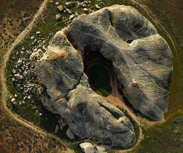
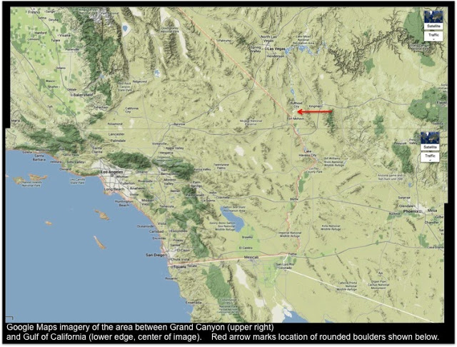
Perhaps few surviving sacred sites in the world display the conflict between those two visions, those two roads described by Black Elk in his vision, more viscerally than the ancient space known today as "Painted Rock," located in North America in a high grassland plain -- in fact, a salt-lake basin with no real outlet, containing a large dry gypsum flat known as "Soda Lake" -- about forty-five or fifty miles inland from the Pacific Ocean in modern-day California. 

This is the arid valley known today as the Carrizo Plain, a name thought to have been derived from the Spanish word carrizo, defined in the Follett Velasquez dictionary as a "common reed-grass, Arundo phragmites," although in previous generations the area was called the Carrisa Plain, possibly an attempt to pronounce the Spanish word.  

It is nearly 1,400 miles from the places that Black Elk and his people lived, but it contains an awe-inspiring natural rock temple which silently proclaims a very similar message and offers a clear view of both roads, both visions: one vision evincing profound connectedness to nature and to the invisible realm, and the other displaying either a conscious hatred for that first vision, or a wanton disregard for it, and arising from a culture that has been cut off from it.

This extensive description of the importance of Painted Rock (and the extensive ancient archaeological region of which Painted Rock is part), prepared and filed in 2011 in conjunction with a request to have the area declared a National Historic Landmark, points to newly-discovered evidence of human habitation stretching back 10,000 years before the present, describing (in addition to the well-known Painted Rock site) "recently discovered pictograph sites along with a remarkable concentration of villages, camps and other sites dating from about 10,000 to 200 BP (8050 BCE - 1750 CE)" (see top of page 4).

This anciently-inhabited region, that same paragraph notes, contains abundant pictographs of a very distinctive nature: for the most part, they are painted with bright colors, instead of carved or indented as is common in other pictographic sites in North America. These, the report notes, "are the impressive hallmark of this district." Some scholars have dated the creation of these particular painted pictographs to a period of about 3,000 to 4,000 years ago. 

These painted markings and significant and impressive in their own right, for their historical and cultural significance, for whatever concepts the ancient artists intended with their work (almost certainly related to the sacred and to the invisible world), and for the unworldly impression conveyed by their subject matter, their often intricate and artistically-beautiful design, and their use of bold colors (particularly red, black and white, often used together, with light blue, ochre yellow, and other colors added at times as well). 

In the massif known as the Painted Rock, shown in the aerial image above, the ancient artists who created these paintings selected one of the most impressive natural spaces possible, one possessed of tremendous inherent spiritual symbolism and power.

The annual report of the State Mineralogist to the California State Mining Bureau for the year 1890 described the actual rock formation, and the pictographs, in these words:

In the southwestern part of the plain stands THE PAINTED ROCK, an isolated butte covering an area of about five acres and rising to a height of one hundred and forty feet -- a conical formation, and hollow like the crater of a volcano, but having a narrow opening towards the east on a level with the surrounding plain [the opening is actually more north than east]. This opening is twenty-four feet in width and leads to a vast oval cavity two hundred and twenty-five feet in its greatest, and one hundred and twenty feet in its least diameter, the walls rising to a height of one hundred and thirty-two feet in the highest point. The rock is coarse sandstone, the walls irregular, and overhanging in places, making the inner space like a cave. In these recesses, covering a space of twelve feet in height, and sixty feet in length, are a great number of paintings, representing strange figures in rude forms of men, suns, birds, and others indescribable -- probably hieroglyphics or writings of meaning to the prehistoric people who made them. When and by whom these were made is unknown, as the oldest inhabitant says that when discovered by the pioneer Spanish missionaries, they found them as they are at the present time; the aborigines knowing nothing of their origin, but regarding them with mysterious awe. The paintings are in three lines of red, white, and black, the colors still bright and distinct. This grand temple of the ancient pagan is now utilized as a corral. Upon many rocks bordering the great plain are similar paintings of the same unknown origin. "Painted rocks" are also found in Santa Barbara and Kern Counties, with figures of the same character as those of the San Luis Obispo rocks, and would be a proper subject of study for the ethnologist. 569.

This account, dated from the end of 1890 and thus written by one who visited the area that year or slightly earlier, provides some valuable historical information, particularly regarding the condition of the rock paintings, as well as the fact that their original artists were shrouded in the mists of the ancient past, at least according to whatever sources the surveyors contacted and whatever answers they saw fit to give to him. 

Based on current historical paradigms and analysis of the art itself, most modern scholars ascribe the rock art to the Chumash and Yokuts peoples, each of which has their own distinctive artistic and thematic characteristics but which apparently also have many characteristics and themes in common as well. According to sources cited in page 18 of the National Register of Historic Places form linked previously, many scholars generally believe that the majority of the art comes from the "Middle Period" stretching from 4,000 years to 800 years before the present day, or from about 2050 BC - AD 1150 (and at one point, based on arguments from lake levels of the Soda Lake basin, the report narrows that down to a range of about 2050 BC to 50 BC).

What is fairly certain is that the stunning art of the awe-inspiring Painted Rock sacred site, and that found along certain outcroppings and formations dotting the hills and the edges of the plain in the surrounding region, survived intact and in a remarkable state of preservation for the better part of 4,000 years. 

Some early black-and-white photographs taken of the pictographic murals within Painted Rock itself are claimed in books published not long afterwards to have been taken as early as 1876, which may mean that they are the very first pictographs to have been photographed anywhere in the world. Photographs of the Painted Rock pictographs from the early 1890s were published in a 1910 article in West Coast magazine and in a subsequent 1910 book written by regional historian Myron Angel (you can read the text of that book online here, and order a copy of the original through various bookstores and online used-book channels). 

Other fascinating photos from the 1890s were included in a 1981 book called Curse of the Feathered Snake by Angus MacLean, who uses a story related by Myron Angel as a basis for some of his own proclamations about the history and significance of the sites and their pictographs.

In all of those photographs from the end of the 1800s, and in the descriptions in Mr. Angel's 1910 account, the pictographs are almost completely intact, looking very much as they had looked for the previous 2,000 to 4,000 years -- twenty to forty centuries.

But some vandalism had already begun to take place during the 1800s, with visitors descended from the western European cultures carving their names or initials right through these beautiful ancient pictographs into the soft sandstone, and not long after the turn of the century the real desecration of this ancient site accelerated. It is thought that it was in the decades leading up to World War II, particularly in the 1930s, that some of the most dramatic and intricate of these ancient paintings were hideously disfigured: great sections of paint was sacrilegiously and deliberately flaked off, and apparently some of these sacred figures were even shot with firearms and irretrievably damaged.

Ancient pictographic texts which had thus survived up to four thousand years in beautiful condition, preserving their message for perhaps forty centuries could not survive through what we know as the "twentieth century."

Below are links to two sites containing excellent photographs from recent years, by visitors who have made their way to this special monument and who have been appalled by the wanton destruction of the rock art. Each provides comparisons to some of the black-and-white images from the late nineteenth and early twentieth century, to show their disfigured condition in the present day.

The first is a site containing the photography and writing of David Stillman, and an entry entitled "Then and Now: Painted Rock, Carrizo Plain" and dated August 13, 2014.

The second is a two-part trip report published by "Death Valley Jim" (Jim Mattern), a desert guide, wilderness scout, and advocate of low-impact and Leave No Trace outdoorsmanship -- he was so dismayed and angered by the damage done to these pictographs that he vows never to return to Painted Rock again: "Carrizo Plain National Monument and Painted Rock, part 1" and "Carrizo Plain National Monument and Painted Rock, part 2" (both from a very recent first visit, during the beginning of August 2015).

Both are of course right to be outraged and to express their outrage: the deliberate destruction of these ancient sacred sites is a criminal act, one that steals from the heritage of the entire human race and from all future generations, and one that defiles, disrespects, and denigrates sites that are still actively used and held holy by the Native American people whose people and whose ancestors have lived in this land for thousands of years.

Nor is it going too far to state that the message that this site has embodied for so many millennia -- in its own natural power and symbolism, and in the message of the pictographs (which is examined a bit further in the following paragraphs) -- exemplifies the vision of connection with the natural universe, connection with the spirit realm which infuses and indwells every single aspect of this seemingly material realm, and the elevation of that spirit in all people and in all animals and plants and rocks and trees, for the purpose of blessing and renewal.  

Blasting away at that vision with a shotgun at close range, or otherwise deliberately destroying the pictographs which proclaim our connection to the invisible world (such as by flaking off parts of the stone in order to try to take the images away from the site, or just to ruin them forever) clearly exemplifies the very worst aspects of the "bad road" which Black Elk spoke of -- the very worst aspects of that "gnawing flood, dirty with lies and greed" which he described as washing over everything and everyone that once were connected but which have now become isolated and divided and debased.

For more on the way that the sacred enclosure of Painted Rock points to another vision, please first have a look at the previous post entitled "Two Visions," which describes the remarkable analysis presented by Dr. Peter Kingsley, a philosopher and scholar of ancient philosophy (especially pre-Socratic philosophy), in his book In the Dark Places of Wisdom.

Any attempt to "sum up" that ground-breaking book will be incomplete, but one of its central themes involves another way of expressing the very same "two conflicting visions" that Black Elk was also describing. 

Dr. Kingsley provides evidence from archaeology and from the surviving fragmentary texts of ancient philosophers -- and in particular the important pre-Socratic Parmenides or Parmeneides -- showing the existence of a line of ancient wisdom, passed down through one-on-one discipleship, that involved going into dark, cave-like places which connected to "the Underworld." The connection to the Underworld, however, was actually internal -- and the Underworld was a realm of non-ordinary experience to which we all can have access at any time, if we know how to turn ourselves "inside out and find the sun and the moon and the stars inside," as In the Dark Places of Wisdom puts it on page 67.  

This ancient knowledge, Dr. Kingsley asserts, this understanding of the inner connection to the Infinite, was actually at the heart of ancient "western" philosophy -- until it was deliberately stamped out.

And, once it was stamped out, the heirs of that culture all the way down through the centuries in western Europe since those centuries, turned to the other vision (the other "road"): trying desperately to pursue, to grasp, to appropriate something that will fill an emptiness inside -- without realizing that the thing they need (but cannot even recognize) is actually already to be found within.

He writes:

Western culture is a past master at the art of substitution. It offers and never delivers because it can't. It has lost the power even to know what needs to be delivered. [. . .]. 35.
[But, we actually] already have everything we need to know, in the darkness inside ourselves. 67.

There is no denying the fact that the Painted Rock formation fits the description of the dark places where the ancient pre-Socratic wisdom teachers would seek to convey the truth that we already have what we need, and to teach the method of going into the "Underworld" that is actually located in a non-ordinary location: in the darkness inside ourselves.

In fact, in the book, Dr. Kingsley points out that the surviving fragments from the poems of Parmeneides describing this internal Underworld journey explain the descent as being led by a goddess, and attended by female immortal attendants -- and it is undeniable that descent into caves is symbolically associated with the divine feminine.

It can also be pointed out that nearly all the deities and beings human and nonhuman with whom Odysseus has to interact during his epic voyage and return home described in the Odyssey -- from the goddess Calypso to the monsters Scylla and Charybdis to the powerful witch and goddess Circe to the princess Nausicaa of Phaecaia, and of course ultimately to his own wife, Penelope -- are also female figures. And through these interactions Odysseus is also guided to the Underworld in order to gain knowledge that he could not obtain otherwise (and Circe is the one who tells him how to go there, a fact with direct connections to the ancient texts Peter Kingsley discusses as well).

The physical location of Painted Rock quite clearly evokes this same spiritual imagery of the divine feminine.

And now, briefly, to the figures themselves, which some western writers including scholars have chosen to try to interpret literally at some level -- whether seeing them as depicting specific types of turtles or seeing them as trying to depict the shaman who is undergoing a vision-journey.

Writers in earlier centuries (such as the Mineralogist report linked above) often use condescending terms: "rude forms of men, suns, birds, and others indescribable."

And Erich Von Daniken (and others from the same theoretical approach, to which I do not myself subscribe) takes a different kind of literalist approach, declaring that these and other pictographs are literal depictions of spacecraft and beings in spacesuits (whether ancient human astronauts, or ancient aliens). 

Von Daniken specifically points out a drawing of one of the (now largely destroyed) panels from Painted Rock in a 1972 book originally entitled Gods From Outer Space (and available in an online format here under the title Return to the Stars) in the fifth chapter, where he implies that the "different globular figures" might be sphere-shaped spacecraft, and that the humanoid figures in the Painted Rock and other ancient petroglyphs may represent the attempts to render space travelers (and he uses patronizing and condescending descriptions of the level of sophistication and understanding of the artists and ancient cultures that produced this art, comparing them at one point to children given a box of crayons)(see pages 48 - 50).

All of these interpretations, however, could be classified as making the same error as that which is made when ancient sacred written scriptures or ancient myths and sacred traditions are analyzed from a literalistic perspective. I and other authors have shown extensive evidence that the ancient texts and myths are allegorical in nature, based upon celestial metaphor.  I have presented several dozen analyses of various myths and scriptures from around the world in previous blog posts -- lists of those previous posts can be found in links on this page. I could demonstrate this principle with literally hundreds more examples than those found in those previous examinations.

I believe that one of the central purposes of creating these celestial allegories was to convey through metaphor the profound truths that Dr. Peter Kingsley and the great Black Elk are trying to explain to us: that we are in fact already connected to the invisible realm, that the invisible realm in fact permeates every aspect of this seemingly material universe, and that this fact connects us all to one another, and to all other creatures (plants and animals) and to the natural world. 

Literalizing these sacred texts and myths, on the other hand, tends to divide us from one another, and to externalize their message . . . and leads directly to the problem that Dr. Kingsley articulates (in which we run around endlessly searching for substitutes to that which we already have access within) and to the "dirty flood of greed and destruction" that Black Elk describes, a vision of the world in which we are all divided from one another because we are all running after those substitutes, grabbing and grasping and devouring and ultimately destroying.

But, as Dr. Kingsley said in a brilliant metaphor, the ancients taught us that we have to go inside and actually "turn ourselves inside out" to find the sun, moon, planets and stars within.

As I have explained in various previous posts, I believe the celestial metaphors are employed in the sacred myths and texts of the world as a sort of "physical metaphor" to illustrate invisible truths about the spiritual world (the unseen world), and about our condition as physical-spiritual beings inhabiting a physical-spiritual universe.

And that is why I very strongly suspect that the incredible Painted Rock pictographs are also a "celestial text" (or celestial texts, perhaps executed over a span of hundreds or even thousands of years).

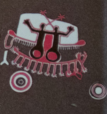
As those who followed the links provided earlier, to the high-quality photographic blogs of David Stillman and Death Valley Jim Mattern, may have noticed, each included on their discussion an image of the original artwork which was painted by the talented Campbell Grant (1909 - 1992), who was an artist who did early work for Disney studios (including work on Fantasia, Snow White, and Pinocchio, as well as the voice of Angus MacBadger in The Wind in the Willows) and who was fascinated with Chumash rock art from an early age and became a serious student of this art, and helped try to preserve it.

In the 1960s, using some of the older black-and-white photographs, as well as visits to the site, he painted this re-creation of the Painted Rock panels as they may have looked before they were destroyed in the 1930s.

I believe we can see very clear evidence that at least some portions of these pictographs are specifically celestial in nature, depicting zodiac constellations, major nearby stars, and the great band of the Milky Way galaxy.

I will focus on just three areas (those that are perhaps the "easiest" to decipher -- if indeed this analysis is correct). I believe there are abundant clues in each of these areas which help make their celestial identity pretty evident. I have my suspicion about some of the other pairings not in these three areas, but I'm less certain of those.

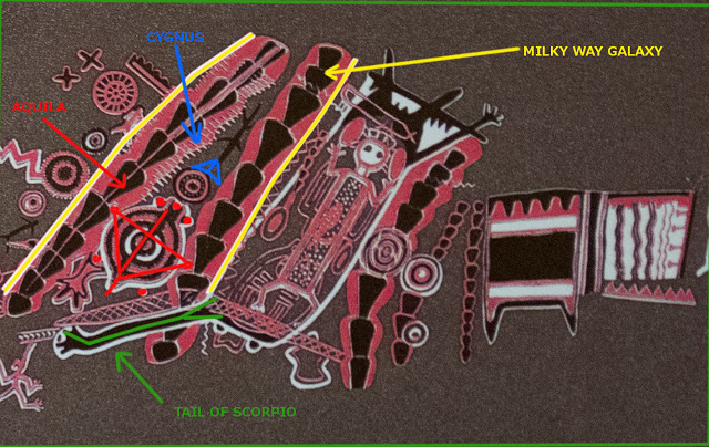
Below, note three areas of the pictographic re-creation by Grant, indicated by a green box, a blue box, and a purple box:

I believe the "green box" constellations and celestial features are perhaps the most obvious -- in part because of the rising columns which could be described as resembling caterpillars or segmented centipedes, or maybe spinal columns (mythologically and spiritually connected to the Djed column of Osiris in its meaning, perhaps -- the raising of the spiritual component in ourselves and in the cosmos around us, in part through connection with the spirit world, through the calling forth of the hidden divine, the Infinite).

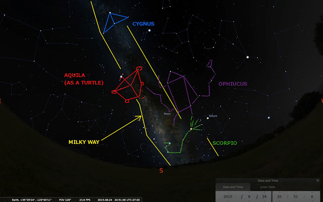
These segmented caterpillars or centipedes I believe are actually the rising column of the Milky Way. Below is a "screen shot" of a scene from the excellent open-source planetarium app, stellarium.org. In it, the rising column of the Milky Way is clearly visible -- and the fact that it actually rises in "two sides" or "two pillars" (especially towards the bottom of the screen) is quite apparent: this is caused by the dark or empty area in between the sides of the Milky Way at this portion, which is known as the Great Rift (discussed here in conjunction with the Maya calendar).

If you are very familiar with the constellations of our night sky, you may be able to spot the zodiac constellation of the Scorpion (Scorpio) in the lower part of that rising Milky Way: the stinger-tail of the Scorpion reaches right into the center of the Milky Way at its base (just above the horizon in the planetarium image above, not far from the big red letter "S" that indicates the direction South on the horizon as we look at the sky).

I believe very strongly that the long reaching black "hand-and-arm-like" feature in the Painted Rock panel, which reaches right into the space between the two rising segmented centipede-like columns (which are the sides of the Milky Way, in my analysis) is in fact the stinger-tail of the Scorpion:

Let's just illustrate that on the star-map and then on the depiction of Painted Rock, so that everyone can see that (Scorpion outlined in green, below):

And below, just in case anyone was not sure what part I believe to be indicative of the part of the constellation we think of as the Scorpion's tail, it is shown on the Painted Rock illustration (and the Milky Way column is also labeled):

There are many other figures in the above section of the Painted Rock panel, which help to confirm this interpretation.

One of the most important of these, I think, is the "Turtle" figure that is shown just above the long "arm" that I identify as the "Tail of Scorpio" in the above image. 

Located right in the middle of the rising Milky Way, above the Scorpion's Tail, I believe this Turtle is in fact the same constellation that we usually refer to as Aquila, the Eagle. Note that the upper "head" of the Turtle can be interpreted as having three "stars" indicated (which Aquila has in its head as well), and then note the little white "tiny paddle-shaped" hands and feet of the Turtle: these are indicative of the locations of stars in the Aquila constellation as well. 

Aquila also has a bit of a dangling "tail," just as this Turtle does in the ancient rock art.

Just above the Aquila, and facing it, is the other great bird of the Milky Way galaxy: Cygnus the Swan. In the rock art above, we see a kind of insect-like "stick figure" which does not really look like a Swan, but which actually has a "double-triangle" shape at the end facing the Turtle. This shape is in fact most reminiscent of Cygnus, even though Cygnus in the sky is much larger than this stick-insect (the rock art depictions are not always exactly done to what we would call "scale"):

And below is the planetarium sky-image again, this time with Aquila the Eagle and Cygnus the Swan also drawn in:

This should be plenty of evidence to at least begin to strongly suspect the possibility that the Painted Rock imagery is celestial imagery. Don't forget that in addition to the three constellations just described, the Painted Rock art also depicts the Milky Way (complete with the Great Rift). In the image of the sky just below, the Milky Way is also indicated.

And, that's not all for this particular portion of the pictograph: there is also the "humanoid" figure just above the "reaching arm" identified as the Scorpion's Tail. 

This humanoid is located just above the head of the Scorpion, which means that it almost certainly represents Ophiucus, the Serpent-Handler -- an extremely important ancient constellation, and one with a very oblong body, just as the humanoid outline in the Painted Rock panel is decidedly oblong:

And then below the outline of Ophiucus in the Painted Rock panel is very much reminiscent of the actual constellation -- complete with the "upraised" portion that you can see on the right side of Ophiucus in the above illustration (the "head" of the serpent he is holding to the right of his body as we look at him):

This analysis should pretty much confirm to even the most skeptical observer that the ancient artists who created the Painted Rock pictographs may well have been depicting the awe-inspiring and spiritually-symbolic constellations of our night sky.

Note the "upraised hand" on the right side of the Ophiucus figure as we look at him (the arrow labeled "Ophiucus" is pointing to it). This corresponds to the "head of the snake" just described in the actual constellation as seen in the sky.

The other two sections of the "mural" that I've outlined with "boxes" are the "blue box" and the "purple box." 

We could do another detailed analysis of each of these similar to that done in the "green box" analysis just above. However, the reader is invited to try to see the connections in these for himself or herself. I believe they add powerful additional evidence which helps confirm that we are dealing with celestial imagery in these ancient "pictographic texts" from the plains of Carrizo.

Below is a detailed close-up of the imagery found in the "blue box":

This one should be fairly obvious. I have placed the correspondences (as I see them) in a "footnote" at the end of this post. Can you guess what the little "dog-bone" shaped item is on the left of the above image, as well as the two "bulls-eye" circles below the main portion of this painting? I believe the two large "bulls-eye" circles are large stars -- which ones might they be?  (My interpretations are below).

And here is the "purple box" section:

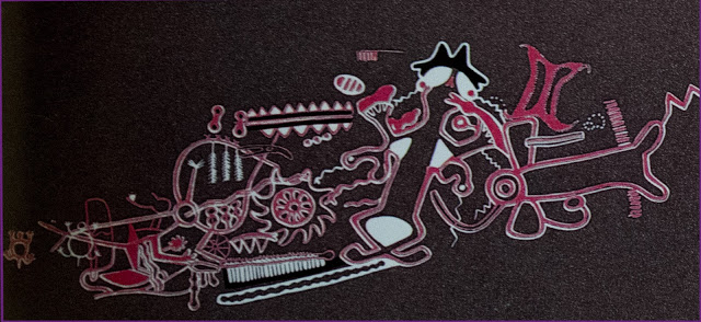
This one is a little trickier.

Look to the far lower-left portion of the selection above: you will see a figure who is kind of "tipped forward" as if running, and some "wavy lines" are kind of "spilling out" of its gut-region (this may in fact remind you of a certain New Testament incident concerning the demise of someone important). The wavy lines are emanating just behind an outstretched arm on this figure.

It is running "the opposite direction" as the direction I would have drawn it, based on the outline of the constellation in the night sky.  

If you want to know my interpretation, see the second footnote at the end of this post. (Hint: It's a zodiac constellation).

Further to the right of that "pitched forward" figure whose "guts" are coming out is a large "lizard-figure" with "crossed legs" and a kind of "painted-in" area inside his crossed lower legs.

Can you think of any constellations in the zodiac which feature two things (the "feet" of this Lizard) that are kind of "tied together" in the way that the "lower legs" of this rock-art Lizard are tied together (or at least crossed)?

If so, what is in between those two items that are tied together or connected in a "v-shape" in the same way that the Lizard's legs are connected in a "V"?

Could that celestial figure between two Lizard legs be a celestial figure whose name is a geometric shape?

I believe that it could. 

In fact, I believe that the figures in the two panels above can be shown to be constellations, just as the first panel we examined in detail contains constellation-art.

I would submit that the presence of a celestial "text" inside of a sacred space (associated with the divine feminine, and with contact with the Underworld realm of the spirit world) indicates that the artists who produced this incredible ancient monument were extremely sophisticated, and that they were possibly preserving and passing on important knowledge about contact with that unseen realm.

It is knowledge that is associated with the first of the two visions offered by Black Elk and by the analysis of Peter Kingsley: the positive vision, the vision of connectedness, the vision of elevating and bringing forth the spiritual aspect in ourselves and in others and in the cosmos around us. 

And this ancient sacred textual repository in this ancient sacred site was literally blasted by desecrators who were either so ignorant of that ancient wisdom that they disregarded it altogether and saw it as having no value at all, or so divisive in their thinking (dividing up humanity into "my group" and "everyone else") that they disrespected the culture that produced it as "primitive" or otherwise unworthy of respect, or else they were (and this is probably the worst possibility) sworn enemies of that vision and that ancient knowledge, and dedicated to suppressing it and keeping it from humanity (to whom it actually belongs as a treasured inheritance given to all people in ancient times, all around the world, in many different forms).

The fact that these descriptions took place in the 1930s is quite disturbing, given the other horrible events that were being unleashed elsewhere around the globe during those years and the following decades.

In a sense, the deliberate destruction of the ancient wisdom in the sacred site of Painted Rock is a visible echo of the deliberate obscuration of the celestial metaphors found in other ancient texts from around the world (including the texts known today as the Old and New Testaments of the Bible). All those ancient texts also employ celestial metaphors -- and I would argue that all of them also deal with the inner connection to the Infinite, and that they indeed can be viewed as "manuals" for connecting with the Invisible Realm.

The fact that Painted Rock is in the condition that it is in today, after surviving intact for perhaps as many as 4,000 years, shows just how relevant this struggle between the two competing "visions" still remains, right up to this very day.

-------------------------------------------------

Below is an image of the area where the panels of rock art depicted by Campbell Grant are located:

The section with the "reaching arm" (which I believe is the Tail of Scorpio) can be seen at the top left portion of the above image, just above the long horizontal crack-line.  The panels to the right of that, where the "blue box" is located for example, is now almost completely obliterated.

My interpretations of the images in the blue box and purple box:

1.  Blue box: The main figures, with the stars above their heads, are almost certainly the Twins of Gemini. The two stars are the stars we call Castor and Pollux. The "linked arms" of the Twins in the rock art is extremely reminiscent of the constellations in the sky.

To the left of the Twins in the sky (for viewers in the northern hemisphere) is the "Little Dog" or Canis Minor, with a bright star Procyon. This may be the little "Y-shaped" dog-bone figure to the left of the image in the blue box of the rock art.

The two big circles that I believe to be two bright stars below Gemini are probably Betelgeuse (on the left in the image) and Aldebaran (darker and not as big). The other possibility is Sirius (instead of Betelgeuse) and Aldebaran.

2.  The "running forward" and falling or tipping-forward figure, with wavy water-lines coming out of his gut-region, is almost certainly Aquarius.  You can even see something like his "Water Jug" in the image, not far from his outstretched arm.  In the night sky, he seems to be running the other direction, but the ancient artist obviously chose to have Aquarius running towards the right in this image.

The "crossed legs" at the lower part of the Lizard are probably the Fishes of Pisces (the feet themselves might be the two Fishes themselves, which in the sky are actually shaped like ovals and not really much like fish). The space between the knees of the Lizard, colored-in in white by the ancient artist (or at least by Campbell Grant in this painting, which he based upon old photographs), is almost certainly meant to indicate the Great Square of Pegasus.

These additional celestial identifications help confirm that what we are looking at in the Painted Rock is a sophisticated ancient site using celestial metaphor, probably as symbolic of the realm of spirit (as is common for celestial allegory literally around the globe, from ancient Egypt to other parts of Africa and China and Japan and Siberia and to ancient Greece and to the Norse people of Scandinavia and as far south as Australia).

The incredible fossils of the Daohugou Biota


On March 04, 2014, a fascinating paper appeared in the Journal of Vertebrate Paleontology, entitled "The Vertebrates of the Late Jurassic Daohugou Biota of northeastern China," by Corwin Sullivan, Yuan Wang, David W. E. Hone, Yuanqing Wang, Xing Xu, and Fucheng Zhang.

The paper discusses the amazing fossils from a region in Inner Monglolia, known as Daohugou, in which the fine-grained sand beds allowed for the preservation of fossilized soft-tissue features, including feather-like quills, the outlines of soft body-parts, and even the external gills of salamanders such as the Chunerpeton tianyiensis, shown above.

The paper discusses the distinctive features of the Daohugou beds and the fossilized fauna preserved there which both link them to other famous fossil beds in the northeastern region of China (including the Yixian, Dabeigou, and Jiufotang Formations), and distinguish Daohugou as having some unique aspects.  The region has produced exquisitely-preserved fossils which the paper describes as including "plants, anostracans, conchostracans, arachnids, and insects, as well as vertebrates." 

The paper discusses various dating estimates for the beds, generally in the neighborhood of 152 million years ago to 166 million years ago, based on radiometric dating techniques (although the paper notes some difficulties with those methods for this region) and on conventional models of the way the various geological layers were deposited (this blog has discussed numerous reasons why both of these methodologies may be completely incorrect, if in fact there was ever a cataclysmic world-wide flood event as described by Dr. Walt Brown's hydroplate theory: see this post and this post for some discussion of the problems with conventional radioactivity assumptions, and this post and this post for some discussion of the problems with conventional stratigraphy assumptions, among many others). 

The presence of such delicately-preserved fossils, over such a wide geographic range, and in such depth (encompassing numerous different layers, with the Daohugou sometimes described as being part of the lower layers of the Yixian Formation), causes tremendous difficulties for conventional theories of fossilization and geographic stratification.  Many of these problems were discussed in a previous post which examined the widespread findings of delicately-preserved jellyfish fossils in areas of the United States, entitled "Jellyfish fossils and the hydroplate theory."  

One of the most obvious problems is the fact that delicate tissue, such as jellyfish bells and jellyfish tentacles, or the external gills on the fossil salamander shown above (and discussed in this section of the paper by Sullivan et al.), or the incredible gossamer insect-wings found in many fossils in the Yixian formation (see image here and at the bottom of this post) does not normally hang around long enough to be fossilized by the mechanisms envisioned under conventional, non-catastrophic theories of fossil formation.  A dead insect lying on the forest floor, or the desert floor, will usually be eaten before it becomes a fossil.  If it is not eaten by something larger, it will under normal conditions decompose and be devoured by microbes long before it becomes a fossil.  Even simple things such as wind and rain will probably rip its wings off and destroy them long before they can be fossilized.  The same goes for jellyfish washed up on a beach, or soft tissues such as the salamander gills shown above.

Even if extremely unusual conditions somehow preserved one insect with gossamer wings, or one salamander with external gills, or one jellyfish by some miraculous set of "just-right" circumstances, how can we possibly explain the abundance of jellyfish described in the earlier-linked post on jellyfish fossils, or the superabundance of insect-wings, salamanders with soft-tissue fossils, plants, and other incredibly well-preserved specimens from the now-famous regions of northeastern China?  How do we explain not only the incredible number and variety of well-preserved specimens, but also the vast region in which they are found?  Did "perfect conditions" just happen to occur -- not just along one isolated stream somewhere, but over a vast swath of Inner Mongolia?  

And the conventional problem goes even deeper than that, because these exquisitely-preserved fossils in the Yinxian and Jiufotang and other formations are found not just along one layer of supposed geographic age, but among many layers -- implying that these "just right" conditions miraculously kept cropping up over and over throughout the course of tens of millions of years (but all in this one region of modern China)!  This kind of explanation beggars belief.  By the way, the jellyfish fossils of the regions of the modern-day US also appear in several different layers, thought by conventional scientists to represent many different ages of ancient history.

As usual, the king-sized problems that the conventional theory cannot adequately explain are handled extremely satisfactorily by Dr. Brown's hydroplate theory.  On this page of Dr. Brown's book (which he graciously makes available to read in its entirety for free online, but which can also be purchased in hardcopy here), Dr. Brown compares the conventional explanation for the formation of the fossil evidence we find around the world with the hydroplate explanation, and allows readers to decide for themselves which explanation better fits the evidence we find.  Dr. Brown's explanation involves the widespread liquefaction which would have taken place during a catastrophic flood event, and which would explain the thinly-pressed and delicately preserved fossils of the northeastern China region as well as the jellyfish fossils of North America.  For a complete discussion of liquefaction, the interested reader is encouraged to read the entire chapter on liquefaction in Dr. Brown's book.

Many of the items from Dr. Brown's list (written long before this latest article appeared describing the fossilized specimens of the northeastern China region) fit very well with the description of the Daohugou and other localities in the recent article.  Some of those include the presence of very fine basaltic sediments to great depths, the breadth of the region, and the sorting of fossils into various "biota" which distinguish one group from another (and which form the primary subject of this latest paper in the Journal of Vertebrate Paleontology).

The possibility that there has been a catastrophic event in this planet's past which is responsible for the fossils we find should not be so difficult to accept -- in fact, as this blog has discussed many times and as Dr. Brown's book discusses in far greater depth, the evidence overwhelmingly leads to that conclusion.  However, such a possibility is so distasteful to the defenders of the conventional academic paradigms that it is almost never even considered, let alone accepted.  This unfortunate bias leads to the acceptance of explanations which should be infinitely more difficult for someone to believe, explanations which posit the perfect conditions that could preserve salamander gills, jellyfish bells, or insect wings not just one time but many times, over wide regions stretching for miles in all directions, and in multiple layers which were formed many millions of years apart!

Perhaps someday some of those scientists who currently talk themselves into believing such fantasies will stop and take a look at the much more scientific explanations offered in the hydroplate theory.


The discovery of vast offshore fresh groundwater reserves (i.e., under the seafloor)


Recently, in the journal Nature, scientists and researchers Vincent E. A. Post, Jacobus Groen, Henk Kooi, Mark Person, Shemin Ge, and W. Mike Edmunds published a study entitled "Offshore fresh groundwater reserves as a global phenomenon."  

The study can be read online here, which allows you to see the first page, and read the rest for a fee of $3.99, but you can also read some of the many articles discussing the importance of this new finding for free online, such as this one, and this one, and this one, and this one.

Reader Terry B., who has alerted me to important new discoveries many times in the past, notified me of this important new development soon after the study was published near the beginning of this month and noted that it seems to be yet another piece of evidence which supports the hydroplate theory of Dr. Walt Brown.  

Sure enough, Dr. Brown agrees that the new finding of large amounts of relatively fresh water (fresher than seawater) trapped underneath the seafloor along the offshore continental shelves around the world is a finding that is difficult to explain using conventional theories, but one that accords quite well with the hydroplate theory.  Dr. Brown has already mentioned this important new discovery, in the section on this page of his book (which is available in its entirety on the web, or for purchase in hardbound print edition here) entitled "Earth's Major Components," where he writes:
Low-salinity water is being discovered far below continental shelves worldwide.  Why would water, typically less salty than sea water, be found beneath the sea floor?
At the end of that question, he provides a footnote (footnote 6) to the article published earlier this month in Nature discussing the vast offshore reserves of fresh water being discovered below the surface of the continental shelves (at depths of up to 3000 meters beneath the seafloor).

While scientists had long known of the existence of some subsurface freshwater discharge from onshore reserves which penetrated out into the shelf offshore, it was previously assumed that such intrusions were fairly limited in scope, both around the world and in terms of how far out from the shore they could reach.  The authors of the new article conducted tests which indicate that the phenomenon of fresh water beneath the seafloor is extremely widespread, found on continental shelves around the globe, and that these trapped pockets of water can be found extremely far out from shore -- at least as far as 100 kilometers from shore, and possibly further!  

The amount of fresh water trapped beneath the surface on continental shelves may be 500,000 cubic kilometers, or 120,000 cubic miles of fresh water -- a hundred times more than all the water that mankind has extracted from aquifers beneath the surface onshore since 1900, according to lead researcher and author Dr. Vincent E. A. Post!  That much fresh water cannot be explained by simple groundwater discharge from onshore sources, the article explains, and so another mechanism must be proposed.  But what could account for so much fresh water trapped beneath the surface of the continental shelf, which itself is beneath the salty ocean?

The study's authors propose a possible mechanism: during ice ages, sea levels were much lower, and so areas now offshore were once on land.  These areas collected rainwater (called "meteoric" water), and then later when the ice ages came to an end (or, more precisely, an "interglacial" period in between ice ages), that meteoric groundwater was trapped below the surface as the sea levels rose -- and it is still there today.  For this reason, the recent article calls these newly-discovered freshwater reserves offshore "Vast Meteoric Groundwater Reserves" or VGMRs.

There may be some problems with this explanation, such as the question of how the ground that was porous enough to let the freshwater in during the glacial period, became such an excellent sealant that the freshwater was able to stay mostly fresh once the glacial period ended and the salty seawater filled back in over it.  Certainly that could have happened in some unique conditions, but how could it have happened over such a vast extent of the continental boundaries, and to distances of over 100 kilometers from the present shore?

We have already seen in previous discussions that the hydroplate theory does argue that the sea level was in fact much lower, in the centuries immediately following the catastrophic flood (the flood which left so much evidence around the planet that it is very difficult to deny that it took place).  During those centuries, the combination of warmer oceans and colder continents did in fact lead to much greater levels of precipitation, and to an Ice Age, and so some aspects of the proposed mechanism from the article in the journal Nature may have taken place.  But, such runoff would hardly explain the vast amounts of water being discovered today, and its ability to remain much less salty than the ocean above for so many years. 

The hydroplate of Dr. Brown, which has a habit of already being ready to provide excellent explanations for evidence that scientists discover years after Dr. Brown published his predictions, has a very good explanation for the fresh water that is now being detected.  In the caption to Figure 59, found on this page of his online book and reproduced above, Dr. Brown explains where all that fresh water might have come from (and, at the same time, why continental shelves are found on the edges of the continents worldwide -- something that tectonics does not really have a good way of explaining).  Referring to the diagram shown above (in terms of "left" and "right" as the viewer looks at the image), he writes:
The velocity and erosion power of escaping SCW [supercritical water] increased to the right and as it jetted upward.  This beveled the edges of each hydroplate, forming today's continental shelves and continental slopes.  Because the water's pressure decreased as it approached the right edge, the hydroplate sagged downward, constricting flow and increasing erosion even more.
During the flood, thick layers of sediments blanketed the granite crust.  Included in those sedimentary layers were aquifers -- deep, permeable, sedimentary layers filled with generally salt-free water.  Today, some of those aquifers lie below the continental shelf which constitutes part of the sea floor.
Also, before the flood, much of the SCW water in the subterranean chamber migrated into the spongelike openings (blue dots) in the chamber's roof and floor.  As temperatures in the SCW exceeded about 840 degrees F (450 degrees C) its dissolved salt precipitated (out-salted, as explained on page 122).  Therefore, it should not be surprising that low salinity water is found under the sea floor, but most geologists are surprised.
Certainly more study of the newly-discovered phenomenon of VGMRs is warranted before we can tell which explanation is a better fit for the majority of the evidence.  However, it would certainly seem that the discovery of these vast reserves of fresh water may well constitute yet another example of a geologic phenomenon which causes conventional theories some difficulty, but which accords well with the events proposed by the hydroplate theory.  


Catastrophic formation of the Grand Canyon: still more evidence, this time from the Mojave Desert


If Dr. Walt Brown's hydroplate theory is correct, and the Grand Canyon is a result of the rapid release of millions of tons of water that had been trapped in two massive inland seas (Grand Lake and Hopi Lake, shown in the image on this page of the online version of his book), then the release of so much water should have left evidence all the way along its path to the ocean.  The evidence of such an event would look very different than the evidence that we would find if the Grand Canyon was carved slowly over tens of millions of years by the action of the Colorado River (the conventional explanation).  

The previous discussion presented just that kind of evidence, in the form of six thousand cubic miles of sediments along the northern basin of the Gulf of California.  However, diving down to the floor of the Gulf of California is not an easy undertaking.  Fortunately, we should expect to find plenty more evidence in between the Grand Canyon and the Gulf of California which could provide clues as to the mechanism behind the Canyon's formation -- evidence that would look very different depending on whether its formation was caused by massive amounts of water moving at very high velocity after huge lakes breached, or whether its formation was instead caused by a relatively small river moving at normal speeds over millions of years.

The image above, from Google Maps, shows the distinctive terrain between the two features (Grand Canyon and Gulf of California), a desert region resembling a vast flood plain, marked by ridge line features that resemble lines of dirt left over by a drainage event.  This area is part of the larger "Great Basin" region, and contains the Mojave Desert.  If you can imagine lining the bottom of a bathtub with dirt, then filling it up with water, and then blowing a hole in the side of the bathtub with a large firecracker (like an M-80) [don't try this at home -- this is only a thought experiment], you might be left with a similar pattern of dirt "eddies" along the floor of the bathroom after all the water flowed out of the tub and out of the bathroom (assuming the water had someplace lower to run towards).

If you explore the terrain shown above in person (and I have spent quite a bit of time crawling around in the regions shown in the map) you will find that it is full of very interesting terrain, and that most of the ridge line features that rise up out of the desert are full of a mix of rocks and boulders of all sizes and shapes.  Some of these have been rounded into spheroid shapes by some process.  According to Dr. Brown's interpretation of this evidence, these provide further support for the hypothesis that the Grand Canyon was the product of massive volumes of high-velocity water, which removed thousands of cubic miles of sediments and flowed towards the Gulf of California like a massive tsunami.  

In figure 136, which is found on this page of Dr. Brown's chapter on the Grand Canyon (under paragraph 13, "Missing Dirt"), he presents a photograph of two such spheroid boulders, located south of Bullhead City, Arizona about a mile east of the Colorado River and a hundred feet in elevation above that river (see image below).  The approximate location of this photograph is marked in the map above with a red arrow.  


What could have rounded these boulders into their smooth shapes?  One possibility is the action of high-velocity water, moving them along the bottom for miles at a rapid pace, and depositing them far from the present river and at an elevation high above it.

These boulders shown in Dr. Brown's book (the same image can be seen in the hardcopy version of his book, on page 205 of the 8th edition) are by no means anomalous to the region.  Other similarly rounded boulders can be seen in the Coachella Valley, far to the west and south of the red arrow in the image above, but still in the area that would have been flooded by the rapidly-moving water from the breaching of Grand and Hopi Lakes, if the hydroplate theory is correct.  See for example the photograph at the top of this page (linked) showing very spheroid boulders, some piled on top of one another with large gaps in between them.

There are a few possibilities for explaining the boulders in that image, which are located in Joshua Tree National Park at the approximate location of the marker (the red marker, with the letter "A" on it) in the image below:


That location can be found on the map at the top of this post as well -- it is just north of the Salton Sea and Interstate 10 (you can find the Salton Sea on the map at the top of this post -- it is about center from the left and right sides of the image, but closer to the lower edge of the image).

Those boulders could have been carved into spheroid shapes by the wind, although this explanation seems somewhat unlikely (especially as they are piled on top of one another -- the wind would not be expected to deposit large boulders on top of one another in that manner).  They could have been ejected from an ancient volcano in this spheroid shape and left in a pile as shown in the photograph (while this possibility does not seem to be the correct one, especially given the composition of the rocks themselves, it is a possible explanation).  Or, they could have been eroded into a spheroid shape by rolling for miles at the bottom of a huge flow of water, and left in the location we find them today by that water as it coursed down through the maze of mountainous terrain features towards the Gulf of California.

In his discussion of the evidence (again from paragraph 13 on this page of his online book), Dr. Brown writes:

At least 2,000 cubic miles of Mesozoic sediments were stripped off the layers surrounding and above what is now the Grand Canyon. Only then could the 800 cubic miles of sediments be removed from inside the Grand Canyon. All that dirt was spread downstream from the Grand Canyon, primarily into the northernmost 220 miles of the Gulf of California.
Relatively few sediments were deposited along the Colorado River as it flows south toward the Gulf of California. Rounded boulders mixed with sand and clay are often seen where today’s side streams have cut channels 100–200 feet deep. Those rounded boulders show that they were tumbled and transported by high-velocity water. Unsorted mixtures of sand, clay, and boulders show that the turbulent, muddy water suddenly slowed, depositing the unsorted mixture. [See Figures 136 and 137.]

Clearly, if the Canyon were carved by the normal action of the Colorado River over millions of years, we would have to find another explanation for the location and condition of these boulders.  It would be difficult (if not impossible) to explain this evidence by saying that the river has been flowing at a fairly uniform rate and volume for millions of years.

If you read further in paragraph 13 on the web page cited above from Dr. Brown's book, you will find a reference to a recent (2011) study of the very area under discussion, which looked at the geology of the area shown in the map above and said that although the sediments in the area in question have been widely studied for over a hundred fifty years, "their origin remains unresolved and their stratigraphic context has been confused" (Stratigraphy and Depositional Environments of the Upper Pleistocene Chemehuevi Formation along the Lower Colorado River, Malmon, Howard, House, Lundstrom, Pearthree, Sarna-Wojcicki, Wan and Wahl, 2012 -- link to full report).

They offer a new theory for the origin of the sediments in the vast flood plain between the Grand Canyon and the Gulf of California, namely "a single major episode of fluvial aggradation, during which the Colorado River filled its valley with a great volume of dominantly sand-sized sediment."

While it is nice to see conventional geologists arguing for an extraordinary event to explain evidence that clearly calls for such an explanation (and note that their study was published long after Dr. Brown wrote the discussion quoted above, which can be found in his 2008 hard-copy 8th edition, minus the reference to the 2011 study), their explanation still fails to explain the rounded boulders shown in the two locations discussed above.  A flooding river might move large rocks, but it would not be expected to have the velocity to roll them along for miles at high speeds and round them into spheroids, nor would it be able to pile them up in the jumble shown in the Joshua Tree image.

In short, the evidence on the ground in between the Grand Canyon and the Gulf of California appears to support the hydroplate theory, and to refute the conventional explanations.  And that is in addition to the tons of sediments at the bottom of the Gulf of California (which suggest a rapid high-volume dumping, because if those sediments were deposited by a river over millions of years, it would have been expected to build up a large river delta, which is not present at the north end of the Gulf, as discussed in the previous post and in Dr. Brown's books).

All of this evidence can be added to the massive amounts of evidence in the vicinity of the Grand Canyon itself, which suggests that this incredible terrain feature is the product of a catastrophic event involving huge volumes of high-velocity water, and not the action of a normal river moving with normal volumes and normal velocities over the course of millions of years.  And yet teachers in school responsible for the education of children from the youngest grades through graduate school, as well as all the guides at the Grand Canyon itself, continue to insist on presenting the conventional theory as if it were settled fact, and as if anyone suggesting an alternative explanation is way out of bounds.

Missing dirt from the Grand Canyon found on the floor of the Gulf of California!


The Grand Canyon is often included on lists of the "Seven Wonders of the Natural World" (following on the tradition of creating lists of the "Seven Wonders of the World," a tradition which started in antiquity).  It is truly one of the most massive canyons on earth, stretching well over 200 miles, over the course of which its widths span from four to an incredible eighteen miles across, and reaching an average depth of a mile from the rim to the riverbed far below.

The amount of earth that had to be removed to form such an enormous abyss is truly staggering.  The US National Park Service web page lists the volume of the Grand Canyon as 5.45 trillion cubic yards.  This is an almost-inconceivable volume of dirt that had to be removed.  

Where did it all go?

Walt Brown, the originator of the hydroplate theory, who devotes an entire chapter of his book (available online and in print) to the Grand Canyon, recognizes the significance of this question.  He notes that the volume of sediments that had to be displaced totals about 800 cubic miles!  

He also explains that most conventional theories for the formation of the Grand Canyon, such as the idea that the Colorado River slowly eroded this massive canyon (averaging ten miles wide and one mile deep for well over 200 miles) have a real problem explaining where all that dirt went.

The Colorado River empties into the Gulf of California (the body of water between the Baja peninsula), and Mexico itself.  If that dirt was gradually eroded, there should be a massive delta where the river meets the gulf, but the delta there is tiny, containing not even 1% of the volume of dirt that must at one time have been removed from the Grand Canyon (see for instance point 20 on this web page from Dr. Brown's book).

Dr. Brown relates the story of one of the Grand Canyon's most colorful characters from the end of the nineteenth and early twentieth centuries, John Hance (known as "Captain" John Hance, or sometimes "Cap").  He became famous for regaling visitors with his tall tales, including his explanation of how the mighty canyon came into being.  Quoting a description of Captain Hance's famous account of the canyon's origin, given by former Arizona governor and former US Secretary of the Interior Bruce Babbitt, Dr. Brown relates:
Children loved John Hance, and to them he always explained how the canyon came into being.  "I dug it," he would say simply.  This story worked well for years until one little four-year old girl asked seriously, "And where did you put all the dirt?"  Hance had no ready answer; he never used that story again.  But it bothered him the rest of his life, and when he was dying he whispered to his waiting friends, "Where do you suppose I could have put that dirt?" (from this page in Dr. Brown's online book, quoting Bruce Babbitt -- see footnote 4. on this page).
For more of John Hance's deadpan tall-tales, see this description of the colorful Grand Canyon guide.  Apparently, the question of where all that dirt went made a deep impression on Captain Hance, and troubled him to the end of his days.  It is a question that conventional geologists have yet to answer.

However, the hydroplate theory of Dr. Brown provides an answer for the question of where all those cubic miles of dirt ended up.  As related in previous posts, and discussed in greater detail in his book, Dr. Brown's hydroplate theory argues that the Grand Canyon was not carved by the mechanism of slow erosion by the Colorado River over millions of years, but rather that it was created in a relatively short period of weeks or months by the catastrophic breaching of two enormous inland seas, each one of which were left over from a world-wide flood.  Previous posts pointing to evidence that makes the conventional theory difficult to accept but which support Walt Brown's theory for the formation of the Grand Canyon include:
If the Grand Canyon is a product of a massive, high-volume and high-intensity outpouring of millions of tons of water from two huge inland seas left over from the world-wide flood (you can see where Dr. Brown believes these two huge water bodies once stood on this map in his online book), then the final resting place for all that dirt would be very different than if the dirt were removed gradually over millions of years by a relatively small river.

In fact, the sudden breaching of two enormous water bodies of the size described by the hyrdoplate theory would have removed even more dirt than was in the Grand Canyon, as massive as that is.  According to the hydroplate theory, the breaching of these two inland seas removed at least 2,000 cubic miles of sediments above what is now the Grand Canyon, in addition to the 800 cubic miles of sediment that had to come out of the canyon itself.  You can read in his book how the removal of all that sediment caused the layers below to arch upwards, a phenomenon whose evidence is clearly visible in the geology of the region of the Grand Canyon, and in places to crack (Marble Canyon was caused by this upward arching and subsequent cracking motion).

All those cubic miles of sediments were washed away by the violent release of the two huge lakes, and they swept along until they dumped into the sea -- in this case, they dumped into the Gulf of California, where the Colorado River still meets the sea today.  Along the way, many sediments were deposited into the region between the Grand Canyon and the Gulf of California, but a huge quantity of them dumped into the gulf and they are still there today.

The image below, from Dr. Brown's book here (see section 13, "Missing Dirt"), contains modern three-dimensional imagery of the Gulf of California showing where all those sediments ended up.  Dr. Brown's caption for the image reads in part as follows:
Here's the Dirt.  It's right where we would expect it, if we understood the Grand Canyon's rapid and violent formation.  Hidden beneath the flat floor of the Gulf of California are at least 6,000 cubic miles of sediments.  That basin, bounded on the south by the largest islands in the Gulf, has an area of 15,000 square miles (220 miles long and 60-100 miles wide).  Sediment depths are up to 1.2 miles thick!  About half the basin's sediments were rapidly transported from the Grand Canyon (on the figure's northern horizon), along the path now occupied by the Colorado River.
Why is the Northern Basin's 15,000-square-mile floor so flat?  Within weeks, a few thousand cubic miles of sediments were swept into the basin.  The larger particles settled out first, near today's shoreline.  Finer particles settled out last, but until they did, the muddy water, because it was denser, flowed to the basin's deeper regions where the mud eventually settled, flattening the seafloor.
You can see water depths for the various parts of the Gulf of California in this 1956 study of the feature, "Oceanographic and Meteorological Aspects of the Gulf of California," by Gunnar I. Roden.  The excellent bathymetry charts on pages 22 and 23 of that study clearly show that while the northern portion of the gulf (where Dr. Brown's theory says the sediments were dumped) has depths below 200 meters, the rest of the gulf reaches depths of over 2,800 meters!  In other words, if Dr. Brown is correct -- and the evidence from the Gulf of California seems to support his argument -- then the depths of those sediments are truly astonishing.

This evidence is just one more of many pieces of evidence surrounding the formation of the Grand Canyon which appears to refute the conventional explanations and support the explanation put forward in Dr. Brown's hydroplate theory.  The evidence for the hydroplane theory from the Grand Canyon alone is extremely compelling, but that is just one geological feature among literally several hundred more that Dr. Brown examines in his book, all of which contain evidence which appears to support his theory.

Based on all this evidence, the conventional theories seem about as plausible as Captain John Hance's wry explanation for the origin of the Grand Canyon.  Or, to say it another way, Captain Hance's explanation appears just as good as the stories that park rangers tell visitors to this day regarding the origin of this "natural wonder of the world."  (But where did he put all that dirt?)


Pacific volcanoes and the problems with the plate tectonic theory


Above is a diagram of the conventional tectonic view of "subduction" -- the action of one plate supposedly diving beneath another plate.  This diagram can be found on Wikimedia commons, and there are many more like it which all show roughly the same concept.

According to the conventional view, when one plate runs into another, it will sometimes dive beneath the other plate, creating a trench (marked in the diagram above) along the line of subduction.  Additionally, the conventional theory asserts that the diving or subducting plate is subjected to intense heat and pressure, which often causes it to melt as it dives deeper and deeper, turning into magma which then works its way towards the surface and creates a chain of volcanoes (these are also shown in the diagram above). 

Note that these volcanoes, according to the conventional theory, should be located on the side of the trench belonging to the plate that is not diving.  The magma is coming up from the melting of the front edge of the subducting plate, which is now underneath the non-diving plate (the edge of the diving plate is now on the far side of the trench from its plate, and as it melts its magma bubbles upward on the side of the non-diving plate).  

In other words, in the diagram above, we see a subducting plate coming from the left, and a non-diving plate on the right.  The volcanoes should form on the right of the trench, in the plate on the right, but they are the product of the front edge of the plate coming from the left.  The front edge of the left plate, which is subducting and is now under the right plate, creates the magma that forms the volcanoes.

Below is another diagram showing almost the same process, but this time instead of taking place near a coast, it is taking place at sea and the volcanoes are forming on the ocean floor instead of on the continent.


Again, this diagram comes from Wikimedia commons, and again there are many other variations on this diagram that one can find on the internet, all illustrating the same general concept.  

Most people learn these fundamentals of the conventional plate tectonic theory in school, and the explanation sounds fairly reasonable.  However, there are many reasons to challenge this basic explanation for the formation of ocean trenches, and to question the very existence of such a process as "subduction."  

Dr. Walt Brown, the originator of the hydroplate theory, has challenged this conventional explanation and provided numerous examples of evidence which argues against this explanation.  He discusses these reasons in depth, along with his alternative explanation for the evidence, in this chapter of his book on the hydroplate theory, which is available online in its entirety (and available for purchase from Dr. Brown and other book-sale channels).  In fact, he lists seventeen reasons that subduction is an extremely questionable explanation for the evidence that we actually find in the deep oceans, where most of the supposed subduction zones are located on our planet.

Some of the problems with the subduction theory of tectonics have been addressed in previous blog posts, such as this one, this one and this one.  Another problem with the tectonic explanation that has not been addressed directly on this blog before is the existence of volcanoes on the Pacific floor that do not appear to fit the theory -- or the diagrams above -- at all.

As Dr. Brown writes in his book, 
On the western Pacific floor are 40,000 volcanoes taller than 1 kilometer.  They lie among trenches, not on only one side of trenches. [. . .]  If subducting plates generate magma that forms volcanoes, then volcanoes should lie on the side of the trench above the descending plate.  [See Figure 85 on page 150].  Actually, most volcanoes in the western Pacific lie on the opposite side of trenches.  Also most volcanoes in the western Pacific are interior to a plate -- contradicting plate tectonics, which says volcanoes should usually form near plate boundaries.  
The above quotation comes from pages 154-155 of his 8th edition, and can also be found online about a third of the way down this webpage, under the heading "Scattered volcanoes."

Below is an image from Google maps showing the southwestern area of the Pacific ocean floor.  You can see for yourself the volcanoes which Dr. Brown is discussing in the quotation above, and consider whether the plate tectonic explanation is a good one for the evidence that we actually find, and whether the reality looks anything like the subduction diagrams shown above:


In the map, you can clearly see trenches toward the west (left) side of the image -- some of the deepest ocean trenches on our planet, in fact.  The conventional view is that the plate to the right is subducting under the plate to the left to create these trenches, although how it makes those arcs and cusps is another huge problem with the tectonic theory.  However, more to the point of the volcano-location discussion, notice all the volcanoes scattered across the floor of the Pacific to the right of the trenches, some of them extremely far away from any supposed "subducting" activity.  The Hawaiian Island chain is one series of volcanoes in the image, but there are many others that you can see, none of which look like they support the subduction description of events at all.

Dr. Brown believes that the magma that created these volcanoes does not come from a subducting plate -- the magma came from the catastrophic events surrounding a past global flood on our planet.  According to his theory, the entire floor of the Pacific was pulled towards the center of the earth by the physics involved in the flood event.  When this happened, the intense shearing and heat generated magma around the entire edge of the subsidence -- a ring of magma known today as the "Ring of Fire."  The same forces also "depressed, cracked, and distorted the entire western Pacific.  Frictional melting produced large volumes of magma that spilled out on top of the Pacific plate.  Some of that magma formed volcanoes" (154).

This explanation does a much better job of accounting for all the evidence that we actually find in the Pacific.  The tectonic theory, while better than what came before it, has enormous problems.  The "subduction" explanation is one major problem with the tectonic theory, but it is not alone.  Scientists should overcome their aversion to "catastrophic" explanations and consider the hydroplate theory of Dr. Walt Brown, which provides very comprehensive and satisfactory explanations for the evidence we find on our amazing planet Earth.

The geology of the Little Colorado River Gorge


Over the weekend, on Sunday 06/23, aerialist Nik Wallenda crossed the Little Colorado River Gorge on a two-inch-wide steel cable, taking approximately 22 minutes to make the journey.

Many watched the event live on the Discovery Channel, which sponsored the c
rossing.  Some of the footage can be seen here at the Discovery Channel website.

Some Native tribes protested the event, arguing that the canyon is sacred to their people and should not be used for a publicity stunt.  Others assisted in the event, and the Navajo Nation provided the permit in exchange for the clean up of some platforms and cables left behind for decades after a planned crossing in the 1970s that never took place due to lack of funding (according to this article).

Whatever your opinion of that controversy, Wallenda successfully accomplished the incredible crossing over the 1,500-foot chasm.  The geology of the location is absolutely breathtaking.  It also provides important clues about our planet's past.

Below is a map showing the location of the Little Colorado River Gorge.  It empties into an area of unusual erosion called Nankoweap Canyon, near the point where it comes together with the Colorado River.  This junction of the the Colorado and Little Colorado is called the Confluence and is sacred to the Native tribes of the area as the site of the most ancient inhabitants of the region.


Both Nankoweap Canyon and the Little Colorado River Gorge are important clues to the mystery of the formation of the Grand Canyon, and they present geological evidence that confounds conventional theories.

Dr. Walt Brown, the originator of the hydroplate theory, believes the Grand Canyon was formed by events that took place in the aftermath of a global flood, and his theory provides an explanation for the Little Colorado River and Nankoweap Canyon (as well as for the very difficult-to-explain turn in the Colorado River seen in the map above, where the river that was running generally north-to-south takes a hard right turn to the west and plows right through the enormous massif of the Kaibab Plateau, which is colored green in the map).

Previous posts have detailed Dr. Brown's theory for the creation of the Grand Canyon -- see for example:
n and surrounds, see for example:
Dr. Brown believes that the mechanisms that formed the Grand Canyon and surrounding features began with two large bodies of water that were trapped after the floodwaters drained off the earth, and uplifted by the physics related to the rapid formation of the Rocky Mountains, whose weight caused them to sink downwards, forcing the Colorado Plateau upwards.  

Dr. Brown calls these two lakes "Grand Lake" (further north) and "Hopi Lake" (further south), and diagrams where they were on this map. He believes that Grand Lake eventually breached catastrophically due to increased rainfall and runoff after the flood (caused by warmer oceans). The tons of water cascading out of it eventually undermined the walls holding in Hopi Lake as well, and it breached as well.  The Little Colorado River Gorge marks the location of the breach of Hopi Lake.

About halfway down this webpage, Dr. Brown discusses Nankoweap Canyon and the evidence there which is very difficult to explain by proponents of the conventional theory for the Grand Canyon's formation.  Discussing the detailed image of the Nankoweap Canyon region shown there, he writes:
Nankoweap—Region of Unusual Erosion. This view is looking southeast from 4,400 feet above the ground. The Little Colorado River enters the southern end of Marble Canyon at the top center. The yellow line encloses a region of unusual erosion. Notice that on the top of the high Kaibab Plateau, streams do not flow into the many canyons that are cut into this southeastern portion of the Kaibab Plateau. So, what cut these side canyons, and why are they in such a localized area? Why would the terrain east of Marble Canyon, which is at least 2,000 feet below the top of the Kaibab Plateau and most of this erosion, be so smooth? On top of Nankoweap Mesa are slumps, landslides, and rockfalls. How can rocks fall and mud flow onto the top of a mesa?  
Another point of difficulty for conventional theorists is the origin of the Little Colorado Gorge in the first place.  As you can see from the map above, it seems to spring from out of the desert itself.  Dr. Brown's theory argues that subsurface water burst out of the water table after Grand Lake and Hopi Lake began to empty, and it was this subsurface water which was responsible for creating many of the major canyons that we see emptying into the Grand Canyon from the sides.  The canyons themselves, such as Marble Canyon and the Little River Gorge, are cracks created when the ground arched upwards after the catastrophic breaching of Grand Lake and Hopi Lake removed the material above.  The subsurface water then flowed out the sides of these cracks, creating the side canyons we see today, including the Little Colorado Gorge.

The fact that Nankoweap Canyon was the site of the earliest known habitation in the area is also problematic for conventional geological theories, because they have a hard time explaining where all the water came from that attracted the Old Ones or Anasazi to the area in the first place, and what caused it to disappear, causing them to leave.  This article by Terry Hurlbut discusses this question, and interestingly enough does so in light of Dr. Brown's theory, which provides a satisfactory explanation for the human history of the area.

We can all be glad that Nik Wallenda made it safely across the canyon on his first try.  His feat should cause us to examine the amazing geology of the Little Colorado River Gorge and the Grand Canyon, as well as to reflect upon the sacred traditions of the Native tribes who still remember and honor their ancestors who lived in the region so long ago -- and to consider the ways in which the geology and the human history of this beautiful area are intertwined.