Viewing entries tagged
petroglyphs

Arkaim, gold and the ancient shamanic rituals


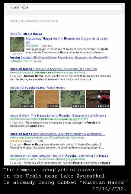
In the previous two posts, we have been examining the implications of the fascinating and newly-discovered geoglyph near Lake Zyuratkul in Russia (in the Urals) that has been dubbed the "Russian Nazca" by some in the media.  See "That's not an elk -- it's a Set-beast!" and "Set-beast and Saiga Antelope" to catch up on the discussion if you haven't seen it yet.

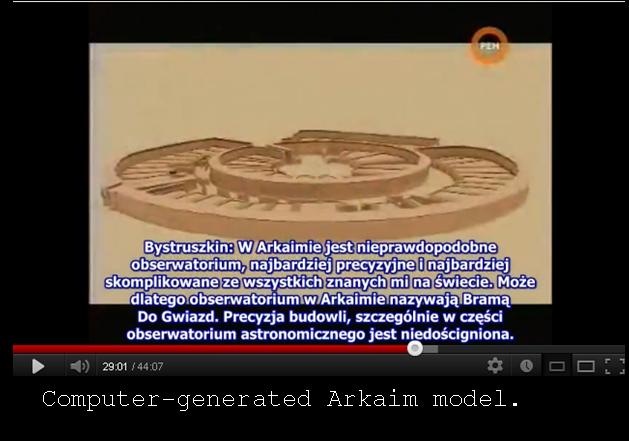
Both posts note that the "new" geoglyph was discovered in a region of the Urals that was already home to significant ancient megalithic monuments, including the stone circles, dolmens, and other structures found around Lake Turgoyak (and particularly Vera Island), as well as the enigmatic circular "city" of Arkaim, discovered in 1987, which has been called a "Russian Stonehenge" (see image above, found in this Russian-language video discussing Arkaim).

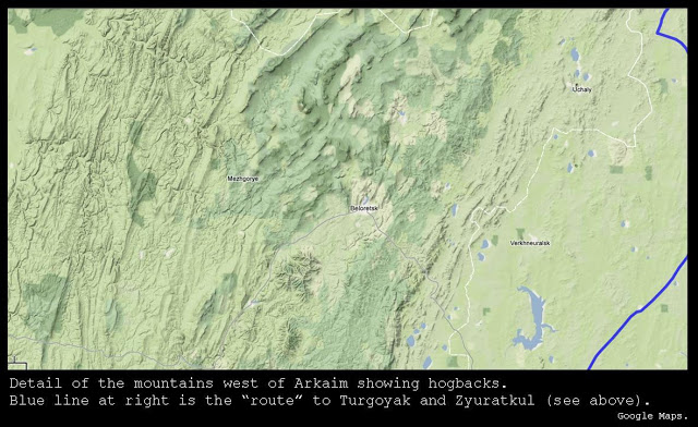
The relative locations of the three sites are shown in the map below:


As pointed out in the previous posts, and as is apparent in the map above, the three sites are located in or near some significant mountain ranges -- and not just any mountain ranges but mountain ranges that are clearly "hogbacks," formed when the strata of the earth are "tipped upwards" and broken off, such that the layers form long parallel ridges as they protrude like long spines.  

We discussed these important terrain features in previous posts, such as "Hogbacks of the California Coast" and "The unbelievable bathymetry of Mavericks."

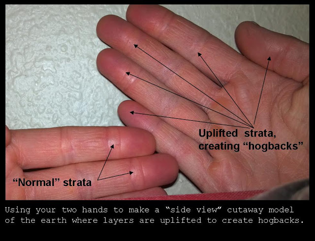
You can create your own model of the formation of hogbacks by holding your palms towards your face while extending the fingers of each hand towards each other, touching the tips of the fingers together (or at least the tips of your two middle fingers).  Then rotate one hand so that the parallel fingers (representing layers of strata) protrude upwards -- these represent your hogbacks, where the crust has been disrupted and pushed upwards such that the layers "go vertical" to some degree, creating a situation where looking down from the air allows you to see the layers that once were beneath the earth but are now protruding.


Below is a close-up view of some of the mountain ranges to the west of Arkaim, clearly showing hogback geology.


We have seen that hogbacks -- perhaps by virtue of their "uplifted" formation mechanism -- often prove excellent locations for mining for precious metals, including gold (such as in California) and copper (such as in Michigan's Upper Peninsula).  Hogback regions can almost be thought of as locations where surface-dwellers can more easily "leaf through the pages" of the earth's strata in search of precious metals and minerals.

This certainly appears to be true of the Chelyabinsk region of the southern Urals where these concentrations of ancient monuments are being discovered.  The area has been and continues to be an important mining region in modern times, and it appears that the ancients also conducted mining activities in the area.  In fact, this extensive discussion of the incredible ancient ruins of Arkaim reveals that not only was this circular city-site a functioning astronomical observatory of great accuracy, but it also contained "remnants of [. . .] metallurgic furnaces, and mines."

This fact is very interesting, especially given the great age and apparent sophistication of Arkaim.  The possibility that this area may have been chosen due to the mining resources may be extremely significant.  Lucy Wyatt (whose work we have discussed in previous posts, such as this one entitled "The shamanic tradition in ancient Egypt") has noted that many other very ancient settlements -- such as Catal Huyuk -- are also located in mountainous regions, which is not what we might expect if we follow the conventional theory that mankind's earliest city-building centered around the transition to agriculture from hunter-gathering.  

Forbidding mountains are not ideal sites for agriculture.  Why are very ancient sites such as Catal Huyuk and now Arkaim located in mountainous regions?  In her book Approaching Chaos: Could an Ancient Archetype Save 21st Century Civilization, discussing the enigmas of ancient civilization and the evidence that it did not follow the pattern our conventional historians propose, Lucy Wyatt argues that these ancient sites were located in these mountainous regions because the ancient civilizers were more interested in gold than in agriculture!

In a chapter entitled "Why Civilization Mysteriously Starts in Mountains," Lucy writes:
What was the reason for spending so much time and effort in such in such difficult and unprepossessing terrain?  What was so important to the ancients about inhospitable mountains both in the Middle East and South America?  Oddly enough, Genesis itself gives one answer: gold

In mentioning the first river to flow out of Eden, the Pishon, Genesis states that this river flows around 'the whole land of Havilah, where there is gold; and the gold of that land is good.'   [. . .]

Mesopotamia to the south had a word for gold, KU.GI, but no gold itself [Potts, 1994, p164].  It all came from the mountains -- either the Taurus Mountains to the north, or the Zagros Mountains to the east.  When the king of Uruk made his demands in cuneiform tablets on the mountainous kingdom of Aratta in the third millennium BC for large amounts of gold and silver to be sent for the temples in the south at Eridu and Uruk, his request may have been typical of an exchange that had been taking place for millennia beforehand [Rohl, 1998, p75, p130].  

[. . .]  Quite possibly gold deposits were the reason for the ancients being there in the first place -- after all, pottery could be made from clay found anywhere.  66-67.

What gives this argument added strength is Lucy's remarkable analysis of the importance of gold.  She believes that its use went far beyond simple decoration or demonstration of wealth, and that gold in fact played a key function in enabling the out-of-body or shamanic travel undertaken by the priest-kings of ancient civilization.   If these out-of-body shamanic experiences were used to gain critical knowledge -- as the evidence seems to suggest -- and to keep ancient civilization on track for hundreds and even thousands of years, then obtaining gold was not just a luxury: it was a necessity.

As discussed in that previous post on evidence of shamanic out-of-body travel by pharaohs in ancient Egypt, Lucy believes that the qeni garment (also described as the "embrace of Osiris" in ancient texts) may have protected the king's heart during the experience, during which electricity and ultrasonic energy may have also been involved, perhaps interacting with the gold or with a powder made from the gold.  

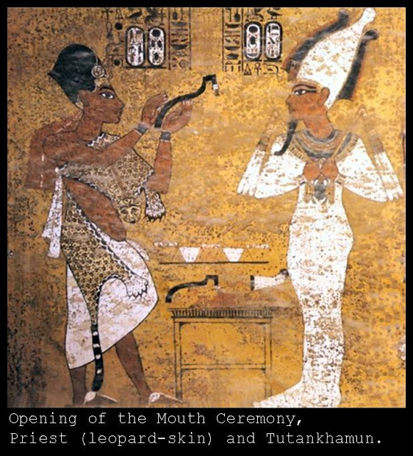
She also believes that the "Opening of the Mouth Ceremony," which conventional historians describe as a strictly funerary ritual, may have been conducted on the living pharaoh during the ritual. This ceremony involved a ritual adze, which is often shown being brought towards the mouth of the pharaoh by a sem priest.  Lucy asks:  "Have we misunderstood 'opening the mouth' when in fact it might have meant 'keeping open the mouth'?  If the pharaoh were lying on his Heb Sed bed in a shamanic trance, then the iron adze might have been necessary both to conduct a mild electrical current and perhaps to stop him from swallowing his tongue" (170-171).


As noted in the first post on this subject of the ancient monuments in the Urals, it may be extremely significant that the one tool singled out for mention as being most prevalent at the newly-discovered "Russian Nazca" shape (which I believe may represent a "Set-beast") is the adze.

Thus, these little-known but extremely interesting (and fairly newly-discovered) sites in the Urals of Russia appear to contain important clues that may support Lucy Wyatt's bold thesis:  They are located in close proximity to hogbacks and in a region known for extensive mining activity (including gold mining).  The site of the enigmatic circular city-compound of Arkaim contains clear evidence of smelting and mining.  They are very old.  And they appear to contain important symbols (in the form of the adze) relating to the civilization-affirming ritual that Lucy believes the ancients needed all this gold for in the first place.

This is an extremely interesting line of inquiry, and (it would appear) an extremely promising one.


That's not an elk -- it's a Set-beast!


Recently, a newly-discovered ancient outline composed of massive lines made of stones of various size, located near the remote Lake Zyuratkul in the Urals has been making news, and rightly so.  

At 900 feet in size at its widest two points, it is larger than even the largest animal-shaped geoglyphs among the famous Nazca Lines in Peru, which it resembles so much that it has been called "Russia's Nazca" (see search results below, or conduct a search yourself).


Like the Nazca outlines, the image is so big that it is really best seen from a high elevation.  In this case, the geoglyph was apparently first noticed by an astute observer named Alexander Shestakov (story here), who noticed the outline while poring over satellite images (which satellite images is not currently stated in the reports that I have seen, but it may have been the satellite images on Google Maps or Google Earth, as the image is visible from those satellite images).

Once he told researchers, they went airborne to confirm the existence of this immense ancient geoglyph, apparently using a "hydroplane" (probably meaning a flying boat or seaplane: the image is located very near to Lake Zyuratkul -- also spelled Zjuratkul -- in the Urals) and a paraglider.

This fact alone is noteworthy, and reminiscent of the Nazca lines of Peru (located on Peru's Nazca plateau and taking their name from that location).  As Graham Hancock wrote of the Nazca lines in his groundbreaking Fingerprints of the Gods in 1995:
Their sheer size is equally noteworthy and bizarre.  The hummingbird is 165 feet long, the spider 150 feet long, the condor stretches nearly 400 feet from beak to tail-feathers (as does the pelican), and a lizard, whose tail is now divided by the Pan-American highway, is 617 feet in length.  Almost every design is executed in the same cyclopean scale and in the same difficult manner, by the careful contouring of a single continuous line. 39-40.
It is remarkable that the image near Lake Zyuratkul also appears to be composed of a single continuous line.  To see the image of the geoglyph for yourself on Google Maps, simply search for "Lake Zyuratkul" (if a map image does not come up, click on "Maps" from the horizontal menu bar at the top of the Google results page, where you have choices such as "Search" and "Images" and "Maps").  Locate the lake itself, and then look to the north and west of the lake (see location of the image relative to the lake in the picture below):


The first news stories to describe this important archaeological discovery and window into the ancient past of the human race are describing the outline as "elk-shaped" or "moose-shaped" (here are a couple examples: "Mysterious elk-shaped structure discovered in Russia," "Russian 'Moose' Geoglyph Predates Nazca Lines").  While it is certainly possible that the ancient designers intended to convey a moose or an elk (other reports say "an elk or a deer"), the creature's elongated snout is certainly much longer than any found on an elk or even a moose, and it has two distinct and vertical rectangular "ears" that do not look at all like antlers but are in fact strongly reminiscent of a very different ancient creature depicted in ancient art.  

I believe that this ancient geoglyph may represent the animal known as the "Seth-beast" or "Set-beast."  That's right: I believe the "Russian Nazca" image may depict the animal that is also found on the head of an important Egyptian god -- you heard it here first!

While this may seem like something of a stretch, bear with me while I explain the reasons for this conclusion.  First, the shape of the outline itself, with the twin vertical rectangular "ears" and elongated anteater-like snout are highly suggestive of the head of the Egyptian god Set (or Seth), brother of Osiris (and murderer of Osiris).  See image below, from the Small Temple at Abu Simbel (reign of Rameses II, c. 1303 BC - 1213 BC).  


You will note that the snout and the ears of the image above clearly resemble the outline of the "Russian Nazca" geoglyph, which also has an elongated snout which tapers to a point, and two rectangular "ears" almost identical to those of Set shown above.

I discuss the reason that Set may be depicted with this unique and distinctive head in Chapter 5 of my Mathisen Corollary book.  I agree with the arguments of Jane B. Sellers in Death of Gods in Ancient Egypt, where she gives evidence that Set's head resembles the stars of the constellation Lepus, located under Orion and representing the judgement of the Ennead (or Nine Gods) which is recorded perhaps most fully (out of the texts we have today) in the Memphite Theology (the text inscribed on the Shabaka Stone).

It is quite evident that the Nazca lines of Peru may have astronomical significance and depict prominent constellations (many analysts have provided evidence for this interpretation, which the reader can readily ascertain through various searches on the web and in literature about the lines of the Nazca plateau) -- it is therefore not ridiculous to suggest that this new "Nazca-like" geoglyph in Russia does as well.

As for the objection that it is outrageous to suggest the presence of Egyptian Set-iconography at a site so far from Egypt, take a look at the image below, which is from a Maya codex known as the Codex Tro-Cortesianus:


As discussed in Hamlet's Mill (by Giorgio de Santillana and Hertha von Dechend, 1969) and also in the Mathisen Corollary book, the above image is extremely suggestive of the images from ancient Egypt showing Horus and Set pulling on a central pillar by means of papyrus and lotus reeds (which are replaced by a serpent in the Maya image above, as well as in the versions of the same scene found in India and Cambodia and other parts of the world).  Notice that the figure on the right in the Maya image also has the elongated "snout" typical of the Egyptian god Set or Seth.  Below is a version of the same scene from the throne of the Pharaoh Sesostris I (thought to have reigned from 1971 BC to 1926 BC):


If imagery representing Set can be found in the New World codices of the Maya, then it is not ridiculous to examine the possibility that the geoglyph discovered in Russia might also represent the animal of the same long-snouted deity. 

There is another important clue that analysts so far have not seemed to tie in to the newly-discovered geoglyph in the Urals, a clue which could help them realize that this outline may represent a Seth-beast and not an elk or a moose (which it does not really resemble at all).  That important clue is mentioned in some of the articles about the new discovery, such as in this article (already linked above and entitled "Mysterious elk-shaped structure discovered in Russia").  That clue is the presence of numerous stone implements described by Stanislav Grigoriev, of the Russian Academy of Sciences Institute of History & Archaeology, who is one of the leaders of the ongoing research at the site of the geoglyph.  The article says:
Among the finds from the excavations are about 40 stone tools, made of quartzite, found on the structure's surface. Most of them are pickaxe-like tools called  mattocks, useful for digging and chopping. "Perhaps they were used to extract clay," he [Mr. Grigoriev] writes in the email. 
As discussed in the Mathisen Corollary book during the examination of the importance of Set, the adze was an ancient tool which was shaped very much like the head of Set, and which may well have been associated with that deity.   The image below shows why there is reason to suspect a connection:


Notice that the email from one of the researchers on-site describes the preponderance of the tools found so far at the geoglyph as "pickaxe-like tools called mattocks."  A mattock is a tool of which one end is an adze (shaped like the snout of the Seth-beast) and the other end is either an axe (an edged tool with a vertical blade) or a pick (a pointed tool).  It doesn't matter whether the mattock is an axe-mattock ("cutter mattock") or a pick-mattock -- what they have in common is that each features an adze.  A mattock, for the purposes of this examination, is an adze, and an adze was (I have argued) associated with Set.

For these reasons, I believe that the recently-discovered geoglyph in the Urals in Russia may depict a Set-beast.  


The Solar Double Spiral


The ancient symbol of the double spiral appears to be closely related to the sun's path throughout the year, and to incorporate the subtle complexities created by the obliquity of the ecliptic and the eccentricity of earth's orbit.

In his books The Stars and the Stones: Ancient Art and Astronomy in Ireland, archaeoastronomer and artist Martin Brennan provides compelling evidence that the double spiral is related to the changes in the sun's path throughout the year.

He notes that the shadows cast by a gnomon throughout the year will create a straight line east-west on the equinoxes, but that on the solstices the shadow's path will actually trace out two hyperbolas (this phenomenon is discussed in a previous post here). Brennan explains how this fact may lead to the double spiral design:
At summer solstice the shadows are shortest and the arc is concave. At winter solstice the shadows are longest and the arc is convex. In archaic astronomy, these were known as the 'horns of the solstice.' At equinox the shadow is straight. If the shadows of the sun are correlated over the period of one year in chronological order following their curvature they form a double spiral. In winter the spiral is counter-clockwise and the coils are wide. The shadows begin to straighten as equinox approaches, and after equinox they begin to wind into a clockwise spiral and tighten. They contract until the summer solstice, straighten again at equinox and return to a left-handed spiral again in winter to continue the process perpetually.

The Boyne Valley artists developed the double spiral and displayed it prominently. Recently, an American artist, Charles Ross, arrived at a double spiral in a controlled experiment documenting the sun's path through the year. Using a stationary focused magnifying glass, he placed wooden planks in a fixed position for 366 consecutive days. The sun's rays burned a pattern in the planks which when graphed showed a precisely executed double spiral. 190.
The burned planks on which Charles Ross has performed this experiment can be seen in this photograph on his website, and the spiral pattern can be seen inlaid on the floor of the gallery (click on the third image from the left at the very bottom of that webpage).

Charles Ross has also created three-dimensional solar art called Star Axis in the desert of New Mexico, including a "shadow field" which illustrates the shadow paths throughout the year from one solstice to the other. By visiting this excellent webpage about the project, visitors can select the winter solstice, summer solstice, or equinox position, and then press "play" to see an animation of the shadow movement on those important annual earth-sun positions (to reach the animations, follow the link above and then click "Solar Pyramid and Shadow Field" in the central horizontal menu bar; next click the link which reads "Shadow Field" in the text portion of the page).

This graceful annual solar motion is also related to the analemma pattern created by the earth's tilt, which causes the ecliptic path to move back and forth across the celestial equator throughout the year (crossing at the equinoxes, as discussed in this previous post and elaborated in greater detail in the Mathisen Corollary book). The other phenomenon which causes the analemma's shape to look the way it does is the eccentricity of earth's eliptical orbit, which causes the earth to speed up as it "falls towards" the sun on its way to perihelion around January 4th each year and to slow down as it "rises away" from the sun on its way to aphelion around July 4th each year. Because the earth is moving faster in its orbit on some parts of its orbit, the sun does not "make it" to the anticipated point (for instance, the culmination point or "high noon" point) at the same time on days when the earth is moving faster as it speeds towards perihelion (because it is still spinning at the same rate, an observer on earth will perceive the sun as lagging a little from one day to the next at the same exact time).

The celestial mechanics surrounding the graceful figure-eight shape of the analemma are thoroughly and superlatively explained in the series of pages and animations in this website from Bob Urschel (use the small blue arrows at the bottom of each page to go to the next page -- it will require looking at all of the pages and videos to fully understand this complex process). The video which shows the sun's ecliptic path moving over and under the celestial equator throughout the year, and tracing out the figure-eight analemma as it does so, can be seen here. The first successful photographic record of the analemma, along with arcs showing the sun's path on the solstices and one equinox, can be seen here.

Having established the connection of the double spiral to the graceful annual motion of the sun from one solstice to the other and the equinoxes in between, we can then note the presence of this powerful symbol around the globe. As has already been noted in the citations from Martin Brennan, it can be found in the petroglyphs adorning the megalithic architecture of the Boyne River Valley in Ireland (where the passage mounds have clear alignments to the solstices, equinoxes, and cross-quarter days). It is also found in the New World, such as in the double spiral shape pictured at top which is carved into Fajada Butte in Chaco Canyon, New Mexico.

We have also noted the presence of spiral patterns on the faces of some of the Tocharian mummies of the Tarim Basin. Martin Doutré has made a convincing argument that this very same solar double-spiral pattern found on the faces of some of the Urumqi mummies is directly related to the double-spiral pattern found in many of the mokos or facial tattoos of the Maoris of Aotearoa -- scroll down to the section entitled "Origins of the Early Maori Moko (Facial Tattoo)." For a powerful example of the double spiral, which was often seen crossing the bridge of the nose in men, as well as along the cheekbones and in other areas of the mokos, see this beautiful portrait of Maori Chief Wi Te Wanewha by Gottfried Lindauer (1839 - 1926).

The presence of the double spiral among the ancient inhabitants of Ireland, the Tarim Basin in China, Chaco Canyon in New Mexico, and Aotearoa or New Zealand can of course be explained by independent and isolated observation of the solar patterns, although it must be admitted that this pattern is extremely subtle and not at all inherently obvious from a casual observation of the arcing hyperbolas of the gnomon's shadow field. It is also possible to explain its widespread appearance as a result of ancient trans-oceanic contact and migration. If it were the only data point to support such a theory, it would not be very strong, but taken together with the extensive other data points which exist in mythology and archaeology, it is a noteworthy addition to the debate.

Finally, William Lasseter has some interesting musings about the possible connection of the serpentine double-spiral to the twisting, spiraling dragons which appear in art and tradition the world over, including in Europe in a blog post here. Interestingly enough, that post also includes the page from Martin Brennan's book explaining and illustrating the double spiral that is quoted above in this post, as well as some very insightful literary analysis of J.R.R. Tolkien's The Hobbit. For readers who are interested in Tolkien and the connection to the subject of the celestial phenomena, be sure to check out this post about the connections between the crucially important constellation of Orion and the elven king Earendil.


The Diamer Basha Dam and the Rock Carvings of the Indus Valley


This recent article entitled "Threatened Rock Carvings of Pakistan" describes the thousands of rock carvings in northern Pakistan that will be submerged by the planned Diamer Basha Dam project along the Indus River.

The dam has been in planning stages for five years and groundbreaking for the construction is scheduled for this month. While the dam will generate needed electricity and provide flood mitigation and sediment controls, it will also submerge tens of thousands of rock carvings, some of them very ancient.

This website details some of the findings of the joint German and Pakistani research that has been conducted on the carvings since 1978. It provides a gallery of additional images of some of the carvings, in addition to the excellent images in the article above.

These carvings appear to contain solar and astronomical imagery reminiscent of the ancient carvings studied by Martin Brennan from the Boyne River valley area in Ireland and discussed in his excellent book the Stars and the Stones.

Modern historians believe these solar images in the Diamer Basha area are much more recent, although dating rocks and carvings on rocks is notoriously difficult and depends in large part upon assumptions and historical models.

Let us hope that some plan to remove and preserve the thousands of petroglyphs and inscriptions can be put into action before these important records of those who went before us are lost. Due to the sheer number of them, and the size of some of the stones, such a hope may be overly optimistic.