The Great Square of Pegasus (and more evidence for ancient contact across the oceans)


The earth continues its progress through its orbit around the sun, and as it does so, it brings forward each star's rising time by about four minutes per night. This has the effect of bringing up all the constellations four minutes earlier each night, of course, and if you have been watching the sky each night at about the same time each evening, you will now notice a distinct change from the beginning of the summer.

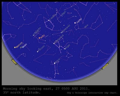
The beautiful constellation of the Scorpion is now much further along each evening, and begins to bend down towards the western horizon much earlier each evening at the same time of night that it used to dominate the center of the southern sky (in the northern hemisphere). Similarly, the constellation of Orion is rising earlier each morning: it used to be rising just before sunrise, but now the first stars of Orion begin to break above the eastern horizon as early as 2 am at a latitude of about 35o north. By the end of September, the first stars of Orion will begin to rise at midnight at the same latitude.

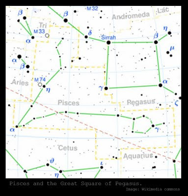
As the sky in the early evening rotates westward, new constellations are now higher in the sky for an observer at 10 pm. One of these is the important landmark of the Great Square of Pegasus, shown above. The Great Square is fairly easy to locate if you can find the constellation of the Swan or Cygnus flying high in the night sky in the band of the Milky Way, and then looking down towards the horizon from Cygnus. To find the Milky Way, one of the easiest ways to begin is to go to the Scorpion again and follow the band of the Milky Way from its origin at the long curving stinger of the Scorpion (it rises between the Scorpion and Sagittarius and arcs across the summer sky, very distinctive and beautiful).

Another way to locate the Great Square of Pegasus is to find the North Star using the pointers on the Big Dipper. Circling the North Star on the other side of the Big Dipper is the "W" shape of the constellation Casseiopeia -- it is quite easy to locate. Using the star at one end of the "W" (the more upright end of the "W" of Casseiopeia, as opposed to the "lazier" side of the "W" which lies down more, as can be seen in the star chart below) you can draw an imaginary line from the North Star through the end of Casseiopeia's "W" and it will lead you right to the Great Square of Pegasus (see the diagram below).


The Great Square is in a part of the night sky that has fainter constellations, so it stands out quite plainly this time of year.

The square is flanked on either side by the constellation Pisces, which resembles two fish tied together by two long cords that are knotted and form a "V" shape -- see the diagram at the top of this post.

The stars of Pisces are very faint and much more difficult to make out than the stars of the Great Square of Pegasus. However, they are very important to ancient mythology found around the world, as discussed by Giorgio de Santillana and Hertha von Dechend in Hamlet's Mill (all of which can now be read online for free at various places on the web, such as here or here, and their diagram of the same Great Square flanked by Pisces can be seen online here).

De Santillana and von Dechend tell us that in ancient Sumeria this astral square was referred to as "l-Iku" and figured prominently in mythology from some of the earliest texts we have from any culture. The authors of Hamlet's Mill explain its significance:
"l-Iku," the Pegasus-square (= alpha beta gamma Pegasi, alpha Andromedae) is, indeed, of the utmost importance, l-Iku representing the fundamental field measure, and Ungnad (Das wiedergefundene Paradies [1923], p. 11) understood the constellation, enclosed by Pisces, for the "Paradise," the primordial field, so to speak. More important, Utnapishtim tells Gilgamesh (GE 11.57) about his ark, which was, like the apsu, an exact cube: "One iku was its floor space." (Before, 11.31, Ea had ordered Utnapishtim: "Like the apsu thou shalt ceil her.") Remembering what we heard above: "Since the ark disappeared there was a stone in its place . . . which was called foundation stone," e.e., Eben Shetiyyah, that covered the abyss, this cubic ark, the floor space of which was one iku, cannot be without interest for us, the less so, when the gods "raised high the head of Esagila (= l-Iku) equaling Apsu." 435 (Appendix 39).Link
Thus, the Great Square enclosed by Pisces appears to represent both the Paradise field and also the ark (Utnapishtim is the Sumerian / Babylonian Noah).

Together with the Great Square, the two fish form an important motif in art from around the world. The square is often depicted as a gameboard, with two fish on either side. It is interesting that in Norse mythology the Aesir gods are often described playing chess in the paradisical field, using golden chessmen -- this probably refers to the same important square.

Note how often the artistic pattern of a square -- either depicted as a gameboard or as a square or parallelogram with cross-hatching reminiscent of a chess- or checkerboard -- appears in art from around the world, accompanied by two fish, or one creature with two fish-tails, or even two turtles arranged in similar angles to the fish of Pisces, their intersecting bodies cross-hatched like a chessboard. You can see them for yourself in the following images shown in Hamlet's Mill: (set one, set two, set three).

Note that the images above are all very similar -- two water creatures and a square "gameboard" pattern being common to each -- and yet some are from ancient Egypt, some are from Africa, one is from Sumatra in Indonesia, and one is from the New World. This recurrence is remarkable, and cannot be simply wished away by isolationists (who do not believe in ancient contact across the oceans between cultures) or put down to some kind of "collective unconscious."

Isolationists must fall back on the explanation that somehow the stars of the Great Square and the surrounding stars of Pisces are interpreted the same way by cultures that never came into contact with one another at all.

This explanation is ridiculous to anyone who goes out and looks at the stars for himself -- while the square would probably suggest itself to anyone from nearly any culture, there is nothing about it that inherently suggests a chessboard or a gameboard. Still less is it obvious that the very faint and hard to find (even if you are looking for them) stars around the Great Square should be interpreted as two fish. That they should be interpreted independently as two fish and a gameboard by cultures from ancient Egypt to the Americas stretches credulity beyond its breaking point.

Such theories would not even be proposed except for the flat refusal of the guardians of conventional theory to admit the possibility of very advanced ancient human achievement (even in the face of quite extensive evidence).

The case of the Great Square of Pegasus is just one more clear piece of evidence in a pile that includes many other powerful clues (see here and here, for example) that there was ancient contact across the seas long before conventional history admits was possible.

Hurricanes and Hamlet's Mill


Hurricane Irene 2011 is beginning to slam into the east coast of the United States, and we wish all those in the path of the storm safety during this uncertain time.

The authors of Hamlet's Mill discuss the origin of the term "hurricane" and some very interesting connections this word reveals with mythologies from around the world. It turns out that the trail back from the word is very important indeed.

In discussing the importance of the shaman's drum, they point to evidence recorded by earlier scholars that the cover of the drum in some traditions had to come from the hide of a black bull, and represented Taurus in heaven (124). They then note the connection to important drums in Chinese mythology, related to an important ox-like creature with one leg (this is a prelude to the discussion of the origin of the word "hurricane"). They write:
There is no need for a detailed inspection of Chinese mythical drums, merely a few lines from an "Ocean of Stories":
In the Eastern Sea, there is to be found an animal which looks like an ox. Its appearance is green, and it has no horns. It has one foot only. When it moves into the water or out of it, it causes wind or rain. Its shining is similar to that of the sun and the moon. The noise it makes is like the thunder. Its name is K'uei. The great Huang-ti, having captured it, made a drum out of its skin.
This looks prima facie like the description of an ancient case of delirium tremens, but the context makes it sober enough. This is a kind of Unnatural Natural History which has small regard for living species, but deals with events from another realm. The One-Legged Being, in particular, can be followed through many appearances beginning with the Hunrakán of the Mayas, whose very name means "one-leg." From it comes our "hurricane," so there is no wonder that he disposes of wind, rain, thunder and lightning in lavish amounts. But he is not for all that a mere weather god, since he is once aspect of Tezcatlipoca himself, and the true original One-Leg that looks down from the starry sky -- but his name is not appropriate yet. 125-126.
The authors of Hamlet's Mill are particularly good at giving hints like this and making you figure out for yourself exactly what they mean. In this case, the bread-crumb trail of clues leads through many important lines of discussion, beginning with their assertion that the Maya Hunrakán (whose name, remember, means "one-leg") is associated with the Aztec Tezcatlipoca, who is usually depicted with one foot missing (or, more precisely, one foot skeletal and the other foot normal).

Giorgio de Santillana and Hertha von Dechend explain that the connection with the leg of a bull (or a one-legged ox-like creature, in the case of the Chinese myth cited above) is quite clear in mythology going back to ancient Egypt, in which the Big Dipper going around the pole star was associated with the leg of a bull (it not only looks like a large spoon but also like a bull's leg and haunch), and because the Big Dipper is associated with the pole or central axis of heaven, we should suspect that these myths with one-legged bulls (or one-legged gods) have something to do with the unhinging of the axis of heaven and the casting down of the previous age (the Age of Taurus, replaced by the Age of Aries).

Through a long series of discussions, de Santillana and von Dechend demonstrate that the mythologies around the world discussing the end of the reign of Saturn are also mythological code for this same celestial circumstance (the changing of the world ages due to the unhinging of the axis), and also in a mysterious and confusing way, so are some mythological aspects of Mars. They bring up examples from many mythologies to confirm this mysterious Mars / Saturn connection, and note that the god Tezcatlipoca actually has two aspects, Red Tezcatlipoca and Black Tezcatlipoca.

The authors of Hamlet's Mill present compelling evidence that these two aspects of Tezcatlipoca represent the curious combination of the aspects of Mars (Red Tezcatlipoca) and Saturn (Black Tezcatlipoca). They explain:
One of the motifs, destruction, is often associated with the Amlethus figure. The other belongs more specifically to Mars. There is a peculiar blind aspect to Mars, insisted on in both Harranian and Mexican myths. It is even echoed in Virgil: "Caeco Marte." But it does not stand only for blind fury. It must be sought in the Nether World, which will come soon. Meanwhile, here is the first double figure of Mars and Kronos. In Mexico, it stands out dreadfully in the grotesque forms of the Black and the Red Tezcatlipoca. There is a certain phase in the Great Tale, obviously, in which the wrecking powers of Mars unleashed make up a fatal compound with the avenging implacable design of Saturn. Shakespeare has, with his preternatural insight, alluded to both when he made Hamlet warn the raging Laertes before their final encounter:
Though I am not by nature rash and splenetic
Yet there is in me something dangerous
Which let thy wisdom fear . . .

Hamlet's Mill, 176.
Below is an image of Red Tezcatlipoca and an image of Black Tezcatlipoca from the pre-Columbian Codex Borgia. Note the one skeletal foot on each:


For some understanding of the connection of Hamlet (who appears in earlier mythology as Amlethus, as well as several other names) with Orion and thus with Osiris and ultimately with Saturn (the god-king who ruled over a previous Golden Age but was cast down and now sleeps in the underworld or some other distant realm or island, as both Saturn and Osiris do in ancient myth), see this previous post.

Thus, the origin of the term "hurricane" is important indeed, involving as it does a god in myth who combines the implacable characteristics of Saturn and the raging characteristics of Mars, and who is associated with the axis of heaven (where his missing leg is circling the pole) and with the unhinging of that axis, which initiated the inexorable grinding of the ages and the end of the lost Golden Age.

The fact that these characteristics are embedded in myths spanning from ancient Egypt to ancient Greece to ancient China and even to Central America is powerful evidence for the existence of a single civilization which bequeathed a legacy of astronomical knowledge to all of these cultures, or to ancient contact across the oceans, or some combination of both possibilities.

These deep concepts are important to understand. They are explored further, along with a much more detailed discussion of the concept of precession which is central to this subject, in the Mathisen Corollary book.

Orion, Sirius, Jupiter and friends in the pre-dawn sky


August is one of my favorite times of year, because if you rise early in the morning before dawn, you will be treated to the spectacular vision of Orion in the east, trailed by Sirius closer to the horizon (in the northern hemisphere). As the earth turns towards the east, the eastern sky begins to grow lighter and become blue, but the bright outline of Orion and the brilliant star Sirius are still clearly visible even after all the other stars fade away in the light of the approaching sun.

Right now, that sight is clearly visible if you get up before the sun. Here is a chart from EarthSky explaining how to find Orion and Sirius for observers in the northern hemisphere at this time of the year. Here is a previous post discussing these particular stars in conjunction with the term heliacal rising and their importance in the mythology of the ancients.

Currently, that awesome annual phenomenon is made even more spectacular with the addition of planets in the morning sky, especially Jupiter. This morning, the beautiful waning crescent moon accompanied them as well, and tomorrow morning it will do so again, but it will be extremely thin on its way to becoming a new moon this Saturday/Sunday. Above Orion, the unmistakably bright Jupiter stayed visible even after the brightening sun had caused Orion and Sirius to fade from view.

The chart above shows the locations of Orion, Sirius and Jupiter in the morning in the east for tomorrow morning (27 August) in the northern hemisphere. It is a portion of the sky chart generated by the very helpful free Interactive Sky Chart tool from Sky & Telescope.

You can see Orion's belt is almost vertical as he rises in the east, as is Canis Major and Sirius rising behind him. Jupiter is located further up and to the right in the diagram, and will be much higher overhead. Jupiter currently rises about 10:33 pm on the night of the 26th and makes its way across the sky, reaching transit at about 5:18 am on the morning of the 27th, at latitude 35o north. It rises and transits three to four minutes earlier per day.

You can also see in the above chart that Mars is located in the vicinity of Castor and Pollux in the constellation of the Twins (Gemini) at the same time. Here is a graphic from EarthSky describing how to find Mars on the morning of the 27th. It also explains how to find Mercury, low in the sky at dawn, tomorrow morning and over the next several days.

Be sure to rise early if possible and enjoy this glorious spectacle in the eastern sky.

More thoughts on mummies


Here is a link to a recent story describing the use of CT scans to examine ancient Egyptian mummies non-invasively, with remarkable images of a newly-scanned mummy from the 20th to 26th dynasty period (anywhere between about 1187 BC to 525 BC).

Note the crossed hands of the mummy, clearly visible in the video above, which is very representative of ancient Egyptian funerary practices and which John Anthony West discusses in some detail in his groundbreaking 1979 work, Serpent in the Sky: The High Wisdom of Ancient Egypt.

Because he argues that the ancient Egyptians were consciously manipulating harmonic forces which are beyond much of the knowledge of science today (see the previous posts here, here, and here), he believes that number and symbol were of paramount importance to everything the Egyptians did. He argues that the crossed arms of the mummy point to the number four, the Pythagorean number of physical substance, as well as to the number five, which transcends matter -- a very powerful concept and quite appropriate for funerary symbolism.

Note the crossed arms and the crossed crook and flail in the images on the funerary equipment of Tutankhamun in the photograph below:


Speaking of the number four and the symbol of the cross, John Anthony West writes in Serpent in the Sky:
Fire, air, earth, water. The ancients chose with care. To say the same thing in modern terms requires more words, and none stick in the memory. Active principle, receptive principle, mediating principle, material principle -- why bother with such abstractions when fire, earth, air and water say the same and say it better.

In Egypt, the intimate connection between Four and the material or substantial world was applied in symbolism. We find the four orientations, the four regions of the sky, the four pillars of the sky (material support for the realm of the spirit), the four sons of Horus, the four organs, the four canopic jars into which the four organs were placed after death, the four children of Geb, the earth.
[. . .]
This is the cross of matter, upon which all of us are pinned. Upon the cross, the Christ, the cosmic man, is crucified. By reconciling its polarities through his own consciousness, he attains unity.

It is this same principle of double inversion and reconciliation that lies behind all religious Egyptian art and architecture. The crossed arms of the mummified pharaoh -- who (whatever his personal traits may have been) represents successive stages of cosmic man -- holds the crossed scepter and flail of his authority. Schematically, the point where the two arms of the Christian cross intersect represents the act of reconciliation, the mystical point of creation, the 'seed.' Upon a similar scheme, the exalted, mummified pharaoh represents the same abstract point.

The cross and the mummified pharaoh thus symbolize both Four and Five. 50-51.
Mr. West follows up this remarkable insight with another which is pertinent to this discussion. First, however, note that the article linked above, with the story about the recently-scanned mummy at the Smithsonian, refers to a newly-expanded exhibit at the Smithsonian which will "explore ancient Egyptian life, religious beliefs and how burial practices serve as windows into ancient cultures, revealing how archaeologists and physical anthropologists gain these insights through their research." It can only be hoped that those insights are being informed by those already recorded by John Anthony West, but it is doubtful.

In any event, Mr. West later writes this observation, which should be clearly kept at the forefront of the consciousness when observing anything related to Egyptian burial practices, including the images of the mummy in the video above: "Now when death is regarded not (as with us) as an ultimate dissolution, but rather as a transitional (and crucial) stage of a journey, then the apparent Egyptian preoccupation with death becomes exactly the opposite of what it seems to be. It is, in fact, a preoccupation with life in the deepest possible sense" (95).

These are important matters which bear further examination and contemplation.

Duke Kahanamoku


August 24 is the birthdate of Duke Kahanamoku, born in 1890. Above is a photograph of the Duke, aged 21, about 100 years ago. An Olympic gold medalist in swimming, Duke's greatest legacy was his towering role as the first real international ambassador of surfing. He is almost singlehandedly responsible for launching the ancient Polynesian "Sport of Kings" in California and Australia and for generously sharing the stoke where ever he went.

Here is a link to a website describing the first recorded western account of surfing by a lieutenant of Captain Cook on a voyage to Hawaii -- subsequent pages describe the role of Jack London, George Freeth, Alexander Hume Ford, and especially Duke Kahanamoku in reviving the sport of surfing and then spreading it worldwide.

Below is a video showing early footage of Duke surfing at Honolulu with Diamond Head in the background.


The video below describes Kahanamoku's 1915 visit to Australia, where his surfing demonstrations fell on extremely fertile soil and can be directly credited with launching that country's well-known fervor for surfing.


Like other legendary Hawaiian watermen, Duke Kahanamoku was also an actual lifesaver, and once dove into the waves repeatedly to save several fishermen in distress when their boat capsized in heavy surf off of Newport Beach in June of 1925.

Surfers everywhere should be grateful to Duke Kahanamoku for his efforts to spread the ancient Polynesian art of surfing beyond the shores of Hawaii in the best tradition of Aloha.

Peace.

Today's magnitude 5.8 earthquake in Virginia


Today at 1:51 pm eastern time, a magnitude 5.8 earthquake shook Virginia, with the USGS reporting the epicenter as a point 38 miles west of Richmond at a depth of 3.8 miles. The earthquake was the largest recorded in Virginia since 1897.

While the location of the earthquake is within a region known to produce occasional small and moderate earthquakes, known as the Central Virginia Seismic Zone according to this USGS description, the mechanism which causes such earthquakes is not well understood or clearly explained by followers of the conventional tectonic theory.

Note that Virginia and the east coast of the United States are far from any "plate boundaries" (see the USGS map in this previous post) where tectonic theory explains earthquakes as resulting from the buildup of pressure between drifting plates. Note that the post referenced discusses the phenomenon of earthquakes far from plate boundaries.

In his book In the Beginning: Compelling Evidence for Creation and the Flood, Dr. Walt Brown provides an extensive discussion of the mechanisms which cause earthquakes and notes the numerous aspects of earthquakes which the conventional tectonic theories have difficulty in explaining (the book can be read online, and the detailed discussion of earthquake mechanisms begins here).

In discussing earthquakes far from plate boundaries, Dr. Brown writes:
The compression event and earth’s vertical adjustments during and after the flood produced many faults throughout the mantle and crust. Only the weakest faults slip frequently and are considered “plate boundaries.” The entire mantle and crust are being compressed and, as shown in Figure 89, laterally displaced generally toward the Pacific. [See “Magma Production and Movement” on page 149.] Therefore, earthquakes sometimes occur far from plate boundaries.
The widespread presence of faults in Virginia is noted here and shown in graphic imagery here. Dr. Brown explains why such faults formed on this page of his online book, and then describes their connection with earthquake activity -- even if far from a "plate boundary":
Today, very slight amounts of slippage frequently occur along faults in the crust and mantle, especially where faults extend from a trench down to the unsteady liquid foundation of the outer core. If, instead of a solid foundation, your home rested on a dense liquid foundation, you can imagine how cracked the walls of your house would be if ripples sometimes pulsed through the liquid or if that foundation rose by the steady addition of dense liquid. Slippage would frequently occur along existing cracks in the walls. Within the mantle, slippage along faults produces more magma, most of which drains into the outer core, adding to its volume and causing more uplift, slippage, and ripples. The mantle is unstable.

Frictional heat generated along faults throughout the mantle conducts slowly into the walls of the fault. Above depths of 410 miles (700 kilometers), local instabilities sometimes arise as heat weakens the solid silicate scaffolding and forms more droplets. Once leaks form, the liquid droplets can escape; their buoyancy forces them upward if they are above the crossover depth or downward if they are below the crossover depth. The scaffolding then will quickly collapse and thereby generate much more heat and melting. Earthquakes—runaway shocks—result.

This explanation is much more scientific than the mechanism offered by the tectonic theory, which postulates a liquid mantle circulating below the crust and occasionally causing earthquakes when slippage occurs between plates, or when pressures build up between plates and they temporarily "unlock." We noted in this previous post that such an explanation is not even truly satisfactory for the activity of the famous San Andreas Fault in California.

Today's unusual Virginia earthquake should provide a good opportunity for greater interest in the cause of earthquakes in general, and of earthquakes far from plate boundaries in particular. Those who examine all the evidence may conclude that the hydroplate theory provides a much better explanation than does the theory of plate tectonics.

The subglacial fjords in Antarctica


Earlier this year, new data from ice-penetrating radar revealed a complex landscape of mountains and fjords deep beneath the Antarctic ice in the vicinity of Wilkes Land (east Antarctica).

A team of researchers from the University of Texas, the University of Edinburgh, the Australian Antarctic Division, and the Antarctic Climate and Ecosystems Cooperative Research Centre published a letter in the scientific journal Nature entitled "A dynamic East Antarctic ice sheet suggested by ice-covered fjord landscapes." In the abstract to that article, they wrote that "The identification of this fjord landscape, based on new data from ice-penetrating radar, provides an improved understanding of the topography of the Aurora Subglacial Basin and its surroundings, and reveals a complex surface sculpted by a succession of ice-sheet configurations substantially different from today’s."

This article from the BBC News provides some close-up of the topographic map of the fjord channels, buried under 3,000-plus feet of ice and below today's sea levels. That article quotes one of the team members, Professor Martin Siegert of the University of Edinburgh, saying:
The modern ice sheet couldn't possibly have done this; it has to have been the consequence of an ice sheet that was much smaller than today's. Comparing our data with geomorphological evidence from other regions of the world, we can be pretty confident that these fjords were formed by fast-flowing ice at the edge of the ice sheet. It's the first evidence we have of how the ice was in phases of growth and retreat as it marched across this subglacial basin to form the ice sheet we recognise today.
In their abstract to the article published in Nature, the scientists surmise that the ice sheet probably began forming about 34 million years ago, and then went through numerous cycles of advance and retreat (up to thirty such cycles) for the next 20 million years.

Of course, these conjectures are based upon the assumptions of conventional geology, which argue that Antarctica has been covered by its present sheet of solid ice for millions of years -- long before the arrival of modern man. We have already discussed how the hydroplate theory of Dr. Walt Brown -- which explains numerous aspects of the earth more satisfactorily than do conventional theories, and which is particularly helpful in explaining some of the mysterious evidence surrounding Antarctica -- proposes a different mechanism for the origin of a past ice age and the ice now covering Antarctica.

In this previous post, we noted that Dr. Brown argues that in order to achieve an ice age, heavy precipitation over cold continents would be necessary. Warm oceans could provide such heavy precipitation, but the conditions that would yield warm oceans and cold continents are difficult to envision under the conventional uniformitarian theories prevalent today. However, Dr. Brown's hydroplate theory envisions warm oceans immediately after the draining of the floodwaters, as well as higher and colder continents than we have today. The continents would have been higher because after their initial slide and thickening, they would not yet have sunk down into the mantle under their increased weight, and thus the sea levels were also lower than today (note that the recent subglacial radar findings also indicate that the oceans were much lower when these fjords were carved, since they are below today's sea level; previous posts have discussed other evidence for lowered oceans and the way this evidence supports the hydroplate theory more than it does conventional theories: see here and here). The oceans would have been warmer as well, due primarily to the energy released during the sliding of the hydroplates. Thus, for some centuries after the flood, the conditions would have been conducive to heavy cloud cover, precipitation as moist air rose over cold continents, and precipitation in the form of snowfall, which would have led to the formation of ice and advancing glaciers.

Amazingly, there are several medieval maps which appear to depict Antarctica with deep fjords and mountains. This fact is amazing on several levels, not least of which being the fact that Antarctica was not known to modern navigators in the west until the nineteenth century. Even more startling is the fact that many of the coastlines and other details on these maps of Antarctica appear to depict a continent not covered by ice -- or, to be more accurate, to depict it when ice probably covered much of the interior but did not cover the coastline the way it does today.

Among these maps are the Piri Re'is map of 1513 (shown above -- the coastline reputed to be that of Antarctica is along the bottom of the image, below and to the right of the east coast of South America), the Oronteus Finaeus World Map of 1532, and the Hadji Ahmed World Map of 1559. A projection of the Oronteus Finaeus map (see here) compared to the outline on today's maps clearly shows the deep fjords of the medieval map versus the relatively smooth coastline depicted on modern maps based on the ice cap which reaches to the ocean and covers up all the folds of the actual coastline.

In the online version of his book on the hydroplate theory, Dr. Brown discusses these medieval maps and their implications for the timeline of the Antarctic ice cap:
These medieval maps, copied 2–3 centuries before 1819 (when textbooks say Antarctica was discovered) were probably based on much earlier source maps. These and other medieval maps also suggest much lower sea levels before the Ice Age. (The hydroplate theory explains why lowered sea levels were followed by the Ice Age.) The maps provide additional information on Antarctica’s mountain ranges, plateaus, bays, coastal islands, and former rivers—under about a mile of ice today. Obviously, the Antarctic ice cap grew rapidly and recently as humans were exploring the earth. The ice cap did not grow, as taught for the last century, over millions of years or before man allegedly evolved.
The ongoing discoveries in the Antarctic, including the new details revealed by ice-penetrating radar in the Aurora Subglacial Basin and published earlier this year in Nature, appear to provide additional supporting evidence for the accuracy of Dr. Brown's theory and its predictions.