Eddie Aikau: May 04, 1946 - March 17, 1978


May 4 is the birthday of Hawaiian hero Eddie Aikau, born this day in 1946.

He was an intrepid North Shore surfer and lifeguard whose willingness to brave the often fearsome Pacific Ocean saved many lives.  His love of Hawaii and desire to preserve and resuscitate Hawaiian spirit and pride are evident in the one part of the above clip in which Eddie Aikau can be heard speaking for himself.

It was these two powerful aspects of his personality that tragically led to his disappearance at sea, when he set out alone to paddle for help, on the third voyage of the Polynesian Voyaging Society traditional vessel Hokule'a, after the Hokule'a had capsized twelve to fifteen miles from shore, and after he and the other members of the crew had waited ten hours in the water without sign of rescue.

His heroic life is truly an inspiration and an example to all people.

One incident of his life that is not as often mentioned, but which also illustrates his stature and the respect that he commanded, was his negotiation of a reconciliation of the tense and violent situation that had developed on the North Shore surrounding the sometimes disrespectful remarks and published statements from non-Hawaiian surfers, as related in the movie Bustin' Down the Door.  The situation is described in detail in the film, beginning around the 55:00-minute mark (although to truly do the story justice, the entire film prior to that point should be seen).

At about 1:12:00 in the film, Rabbit Bartholomew and Ian Cairns, who had published some of the most provocative statements and become the principle targets of those who wanted revenge, describe how they were holed up in a South Shore hotel (in danger of their lives) and heard a knock on the door.
Rabbit:  There was a knock on the door one day, and we opened up the door, Ian's -- I'm there, and Ian's behind me with a tennis racket -- and it was Eddie Aikau.

Ian:  And he just came in and said, 'Look -- you know there are men, men with knives and guns, that want to kill you, for the things you've said in the magazines . . .'

Rabbit:  And he said, 'But, it's gone too far, it's gone beyond the North Shore, it's gone into a much heavier element,' and he said, 'My family, my Dad -- Pops Aikau -- has sent me in, to try to calm the waters a bit here, because it's a very, very serious situation for you two.'

Clyde Aikau:  We did what the Hawaiians called a ho'o pono pono; a ho'o pono pono is, you know, if you've got people who don't agree on something, somehow you bring them, you bring them to your home and then you sit them down and you just hash it out.
This action of reconciliation, in which Eddie Aikau can be seen once again as the one who went into the "stormy waters" of a very intensely-charged situation, was extremely significant for the history of surfing.  It is no exaggeration to say that he probably saved lives by his actions, as well as to say that he may have prevented the derailment of the start of modern professional surfing.

In this incident, just as in the other brave actions he took during his life, Eddie Aikau can be seen to have acted to preserve the dignity, respect, and world-famous Spirit of Aloha of Hawaii and the Hawaiian people and culture.

Our prayers are with the Aikau family this day.

Rest in peace -- Respect.

Beltane and ancient inscriptions in the New World


Above is a drawing of the "Beltane Stone" found at Mystery Hill, New Hampshire on August 31, 1975.  The drawing is modeled on a photograph in Barry Fell's 1976 classic America BC: Ancient Settlers in the New World (page 200).  That book details extensive examples of carvings and other artifacts found in the New World and evidencing usage of ancient languages and ancient writing systems known to historians of the Old World, including Phoenician, Egyptian, and Iberian (among others).

Mystery Hill, New Hampshire features a large calendar circle -- in this case a series of widely-dispersed stones which enable an observer from a central location to view the sunrise on important days of the year, which were marked by prominent upright stones (many triangular or fang-shaped) which lined up with the distant horizon.  The sun can still be observed to rise and set behind these ancient markers to this day (some of the structures at the site may also indicate important lunar stations as well).

This previous post from October 30 of last year discussed the calendar circle in some detail, in light of the approach of an important cross-quarter day, Samhain, a station of the earth's orbit that is the opposite of the cross-quarter day now arriving, known anciently as Beltane.  That post contained a diagram of the calendar circle at Mystery Hill indicating the positions of the stones and the direction to the sunrise or sunset on these important dates, which is reproduced below for convenience:


As discussed in several previous blog posts such as this one, the most well-known stations of the year are the solstices and equinoxes (two solstices and two equinoxes, for a total of four altogether), which divide the year into four sections (in other words, they "quarter" the year).   Those important stations occur near our calendar dates of March 21 (the March equinox), June 21 (the June solstice), September 22 (the September equinox), and December 21 (the December solstice).  

However, in between them there are four other dividing points, which are referred to as the "cross-quarter days," because they are in between the four "quartering" days, and indicate the point midway between each of the "quarters" created by the solstices and equinoxes.  As can be seen from the above diagram of Mystery Hill and the date markers included at that site, these cross-quarter days were also of great importance in ancient cultures.  In particular, Mystery Hill marks the cross-quarter day between the Fall or September Equinox and Winter Solstice (November 1, or Samhain) and it marks the cross-quarter day between the Spring or March Equinox and Summer Solstice (May 1, or Beltane), with rocks whose positions can be seen to this day (it also contains markers for the solstices and equinoxes themselves).

These important cross-quarter days very likely marked the beginning of winter and the beginning of summer, respectively.  As this external article on the subject aptly points out, the solstices are traditionally called Midwinter and Midsummer, which makes sense if they were considered to be the middle of winter and summer, not the beginning (we often hear today that the June solstice marks the start of summer, but it is actually Midsummer).  Thus, the cross-quarter days of Samhain and Beltane (halfway through the quarter of the year preceding Midwinter and Midsummer) would likely be the correct days to indicate the beginning of the winter and summer seasons.

Interestingly (and this has also been discussed in previous posts), the cross-quarter days may have once been reckoned on slightly different days, but migrated a few days to the beginning of their month for convenience.  For example, Martin Brennan's excellent book the Stars and the Stones identifies the cross-quarter days as falling on May 6, August 8, November 8 and May 6 (again, see discussion here).  

These dates create a more even number of days on either side of the cross-quarter days between the previous solstice or equinox and the next solstice or equinox.  This website identifies the cross-quarter days for 2012 as falling on February 4, May 5, August 7, and November 7 (dates given are for those at Greenwich Mean Time -- due to the date-line convention, some parts of the globe will be in a different calendar day when the earth crosses the exact cross-quarter point, just as with the exact passage of the earth through the precise astronomical points of each of the solstices and equinoxes).

The number of days between one solstice/equinox and the next cross-quarter day, or between one cross-quarter day and the next solstice/equinox, generally works out to around 45 or 46 days (sometimes 47 and sometimes 44, and again this will depend on what calendar date is used for the count based on the date-line convention).  

However, what is really fascinating is that the "Beltane Stone" depicted above contains an inscription in Roman numerals for the number "39" (in this case, it is rendered as "XXXVIIII").  Barry Fell believes this indicates "Day 39" -- identifying Beltane as falling 39 days after the Spring Equinox (the Spring Equinox being a traditional ancient start to the year, the day whose heliacal rising zodiac constellation named the entire Age, such as the Age of Taurus or the Age of Pisces or the future Age of Aquarius).

Fell writes that:
In 45 BC Julius Caesar instituted throughout the Roman Empire a new reformed calendar devised by the Greek astronomer Sosigenes.  The date of the spring equinox was now set at March 25, and the new year was set to start on January 1.  The Celts of New England, however, retained the old Celto-Greek New Year that began on the day of the spring equinox; in other respects they followed the revised Roman Calendar, presumably in order to facilitate business arrangements with overseas traders from Spain and Portugal.  May 1, the great Mayday festival of the Celts, called Beltane, now fell on the thirty-ninth day of the year, a fact recorded in the Romano-Celtic inscription on the stone at Mystery Hill. [. . .]  Hence the Beltane Stone dates from about the time of Christ, when the Mayday festival occurred on day 39 of the New England year.  America BC, 200.
Fell's book details many other inscriptions from the New World -- many but by no means all of them in New England -- which feature dedications to the Celtic sun god Bel, from whom Beltane takes its name (appropriate, as the day marks the arrival of the "summer quarter" of the year, one eighth before Midsummer and the other eighth after Midsummer: the portion of the year most dominated by the sun).  

Most of the inscriptions mentioning Bel are in Ogham writing, discussed in this previous blog post and in greater detail in the Mathisen Corollary book itself.  One of these, reproduced below (from page 55 of Fell's text), indicates the Ogham letters (from left-to-right in this case, although just as frequently these were written from right-to-left) "B" (the single line going down below the horizontal "stem-line"), followed by another "B" (another single carving line below the stem-line), followed by an "L" (the two lines closer to one another below the stem-line):


Barry Fell alleges that this inscription should be understood to read "B B-L," meaning "dedicated to Bel" (the Ogham inscriptions in the New World, like ancient Hebrew, did not usually include indications of the vowels, leaving that up to the reader based on context).  

Note that the letter "L" is usually just two parallel lines below the stem: in this case, the ancient engraver decided to embellish his "L" with the "quartered" design that you can see between the carved vertical lines -- it looks something like a window-pane.  Barry Fell alleges that this is a solar symbol, and indeed he produces photographs of a great many such symbols, often a quartered circle (like a Celtic Cross with four equal arms, or a circle with a "plus" symbol through it), which can clearly be seen to be associated with the sun. 

Note that this quartered circle can very easily be understood to convey the sense of the four quarters of the year, divided by the solstices and equinoxes, and indeed you can see that the earth's path around the sun can be thought of as just such a quartered circle (see the diagram in this previous post, for instance).  The inclusion of this solar symbol in the final letter of the inscription appears to be reinforcing evidence in support of Fell's translation of the inscription as a dedication to the solar deity Bel.

Fell also discusses another important inscription found on triangular stones at Mystery Hill inserted into the walls of the same chamber and containing writing on one in saying "Dedicated to Bel" in similar Ogham lines as those depicted above (without the "window pane" symbol) and "To Baal of the Canaanites, this dedication" in Iberian script and the Punic language on another (pages 90 - 91).  About this find, Fell writes: "Bel is the Celtic sun god, long suspected (but until now never proven) to be the same god as the Phoenician Baal" (90 - 91). 

Whether the existence of two inscriptions on two different tablets in the same ancient stone structure proves the direct identification of Bel with Baal is a matter for debate.  However, the existence of these inscriptions at Mystery Hill and other sites (as well as the presence of a stone inscribed with Roman numerals) appears to be compelling evidence for ancient contact from across the oceans.  Even if skeptics were to argue that the so-called "Beltane Stone" with its Roman numerals was the product of colonial settlers after Columbus, it would be difficult to argue that these later colonial-era settlers also produced the Ogham inscriptions.


Giant effigy mounds in South America discovered by Professor Robert Benfer


Professor Robert Benfer is Professor Emeritus of the Department of Anthropology at the University of Missouri-Columbia.  He says, "My research programs should be winding down, but a series of unexpected discoveries has them expanding."  As this recent article explains, Professor Benfer -- who has been involved in archaeological work involving Central and South American civilizations since the early 1970s -- had long observed that ancient archaeological earthworks in Peru resembled animal shapes, but until recently dismissed the idea, saying:
 I had always noted that a very large structure, just north of Lima, resembled a bird. But since there were supposedly no giant animal effigy mounds in South America, I thought it couldn't be.
Now, with the help of the greater availability of satellite imagery, he has confirmed that in fact Peru is home to ancient "effigy mounds" in the shape of birds and other animals -- an extremely important discovery.

This article by Professor Benfer from the September 2011 edition of Antiquity describes these mounds in more detail, complete with imagery from Google Earth Pro.  He explains that these mounds may date from the period 2200 BC to 1750 BC.  The article also points out that, "While geoglyphs are common in Peruvian coastal valleys, they differ from effigy mounds in that they lack three-dimensional structure; both types of monuments are however similar in that they are best viewed from overhead."  

The article also explains that effigy mounds are most commonly associated with the north-central United States.  Many readers are no doubt familiar with the famous Serpent Mound of Ohio (pictured above in a map from the 1800s), perhaps the most well-known effigy mound in the US.  Interestingly enough, the Serpent Mound has been shown to have strong celestial alignments -- including alignments to solstice rising and setting azimuths, as well as to significant lunar rising and setting points -- and the Peruvian effigy mounds discovered by Professor Benfer appear to incorporate similarly significant alignments in their design as well.

In fact, at the end of the article, Professor Benfer notes the possibility that these Peruvian mounds may "represent animals that mirror those in the Andean Zodiac, in the same manner as North American effigy mounds may be seen as representing animals of their respective constellations."  Some evidence that the effigy mounds of the US represent constellations (the Serpent Mound corresponding to the constellation Draco) are linked below.

That these effigy mounds in North and South America appear to incorporate astronomical alignments, and that they might also represent constellations, does not mean that the cultures that constructed them were connected, and Professor Benfer's article does not suggest that they are (the thoughts below about possible connections between widely geographically dispersed monuments are not meant to imply that Professor Benfer believes any such theories). 

While these newer Peruvian discoveries have not been extensively studied yet, there is some amazing analysis of the moundworks of Ohio which suggests that those North American mounds may be in some way connected to other ancient sites around the world, including the Giza pyramids!  The potential similarities between the South American mounds and the North American mounds must of course be explored further, and they may be coincidental similarities that arose in isolation -- but that is certainly not the only possibility, and (just as in a crime scene) all possibilities should be explored and none should be rejected out-of-hand if there appears to be evidence in its favor.

The idea that the North American mounds might intentionally mirror aspects of Old World sites (or derive from a common influence without intentionally mirroring one another) is a startling assertion, but there is in fact extensive evidence found throughout the Americas (and across the Pacific all the way to New Zealand) which suggests an ancient connection with a culture or cultures influenced by the same influence behind the pyramids of Egypt, some of which has been discussed in this blog and in the Mathisen Corollary book itself, as well as in the work of many other authors.  The insistence by the defenders of the conventional narrative of mankind's ancient past that there was no significant ancient contact across the oceans is very strange, given the extent of the archaeological evidence which suggests otherwise -- for one recent discussion of some of this evidence see this post, and for a long list of others (with links) see this older post.

The extensive and extremely sophisticated alignments of the earthworks of the American Midwest are discussed in great detail in some of the articles of Martin Doutré which he makes available on his website, Ancient Celtic New Zealand (click on "Articles" for a list of those, many of which deal with sites outside of North America).


For a discussion of the dimensions and alignment of the earthworks in the area of Newark, Ohio (including the "Octogon" pictured above, which is next to a circle and which together with the circle may represent a spider), see this article by Mr. Doutré.  In that article, he notes that the dimensions of the circle and the octagon have very close correspondence with the dimensions of the Great Pyramid.  We have previously discussed a possible connection in the dimensions of Stonehenge to the dimensions of the Great Pyramid, also based upon the work of Mr. Doutré.

This article, by Ross Hamilton and Patricia Mason also discusses the Octagon and other ancient sites in Ohio, and notes that "The angle of true north off the central axis is very close, if not the same as, the slope of the Great Pyramid, i.e. between 51.5 and 52 degrees" (meaning the angle to true north from the central axis of the Octagon earthwork with its accompanying circle, which you can see in the image above in the upper-left portion of the map: the axis is easy to see because the mound-builders included an actual "neck" connecting the circular head of the spider with the octagonal body or abdomen of the spider).  Note that Mr. Doutré linked to that article and others by Ross Hamilton and Patricia Mason in some of his articles, but that the site he linked to which used to display their articles now contains a fairly generic site about the mounds with little controversial information included, although this page of that site does link to an "archived" section containing the articles of Mr. Hamilton and Ms. Mason.

That material from Ross Hamilton and Patricia Mason also includes a discussion of evidence that the Serpent Mound corresponds to an ancient understanding of the circumpolar constellation Draco.

Mr. Doutré has also written detailed articles examining the alignments and dimensions of other extensive earthworks in the American Midwest, including the incredible Cahokia Mounds of Illinois.  If you take the time to read through all the pages of that article, you will be stunned that you have never heard of this amazing archaeological treasure, and dismayed at the damage that has been done to it over the years (parts of the site have been turned into tract housing, parts have been paved over into a large parking lot, and parts of it were turned into a modern gravel quarry), although some belated attempts to undo these horrible blunders appear to be in progress.  

It is very difficult to argue with the massive evidence that Mr. Doutré presents which demonstrates that the designers of this extensive mound complex possessed a precise understanding of the precessional constant (beyond what either Hipparchus or Ptolemy understood), as well as an understanding of the sophisticated mathematical concept of phi, and -- most astonishing -- a clear understanding of the size of the spherical earth, and navigational concepts required for successfully crossing the bluewater oceans.  Did ancient Native Americans somehow know all of these things, as well as knowing of Stonehenge and Giza?  If so, how?  If not, who else might have had a hand in the design of these little-understood moundworks in North America?

It will be very important to examine the effigy mounds that Professor Benfer has discovered in Peru, to see if important dimensional codes akin to those described by Mr. Doutré in the mounds of Illinois and the Octagon of Ohio might be present there as well.  The other similarities to the earthworks of North America -- such as alignments with important astronomical events, and connection with constellations -- suggest that this analysis may prove to be worthwhile.  The astonishing similarities discussed in this previous post (about aligned stones, V-shaped notches on the horizon, and subtly-sculpted rock faces found in Peru and elsewhere around the globe) also suggest that this new discovery by Professor Benfer may point to connections around the globe.

Professor Benfer is to be congratulated for this exciting new contribution to our collective anthropological understanding -- in addition to all the other work he has contributed to anthropological knowledge throughout his career.  His use of the new wealth of information provided by modern technology -- in this case Google Earth -- has opened an intriguing new perspective on areas he has long examined from "ground level."  Let us hope that we can all learn from his ability to see things from different angles, and from his demonstrated success in following these new perspectives to such fruitful conclusions!  

I for one look forward to his upcoming analysis of this important new development in human history.

Rupert Sheldrake and Morphic Resonance


Rupert Sheldrake is a trained and accomplished plant biologist and holds a doctorate in biochemistry.  He is most well-known, however, for his pursuit of a new explanation for evidence that  defied explanation by the conventional theories of evolution and materialism.  

The controversial new explanation that he offers burst onto the public stage in 1981 with the publication of his book entitled A New Science of Life: the Hypothesis of Causative Formation.  The senior editor of the journal Nature wrote an un-signed editorial about it, entitled "A book for burning?" and pronouncing its ideas "heresy."  Nature is an extremely prestigious and oft-cited forum, and the controversy that ensued effectively altered Dr. Sheldrake's career path for the rest of his life.  

The substance of that first book has since been republished and updated under a new title, Morphic Resonance: the Nature of Causative Formation.  The Greek word morph means "shape"or "form" -- we are familiar with it in many words, including "metamorphosis" ("change-form"), "anthropomorphic" ("man-form-like"), and even "morphine" (a name chosen to refer to the Greek god of dreams, Morpheus, whose name comes from the same root and means "shaper" -- he could take many forms). The term as Dr. Sheldrake uses it refers to the different forms and families of biological species, and his theory of "morphic resonance" proposes that the different forms arose from a process other than molecular changes at the genetic level (variation in form based on genetic molecular changes being the current orthodox and accepted view).  

Instead, he proposes that there are "fields" (energy fields or, more broadly, fields of some type of force) which he calls "morphogenetic fields" -- "form-generating" or "form-producing" fields -- which act to organize the biological material at all levels into their characteristic forms, and that these fields give rise to all the different families of the biological world.  In fact, going beyond this, he also proposes that morphogenetic fields act upon and organize inorganic matter.  However, in the field of biology, he points to evidence discovered by genetic researchers which suggests that the genes between different species differ much less radically than expected, suggesting the possibility that something else might be responsible for the divergence of widely different species with nearly-identical genes.  

He also points to research which has shown that physical traits engendered in adults of a type of water flea (genus Daphnia) are passed on to their offspring.  These fleas "develop large protective spines when predators are around; their offspring also have these spines, even when not exposed to predators" (Morphic Resonance, xxi).  Similarly, he points to research showing that the other members of a species of lab rats which previously learned to negotiate a maze appear to be able to negotiate that maze more readily than lab rats whose species did not learn that maze (4).  That is to say, lab rats who did not previously learn the maze but whose fellows from the same species did, appear to have statistically significantly better scores on a maze once some members of their species take the time to learn it!  The radical implications of such a proposal -- and the reason that it provokes such vitriolic reaction among defenders of orthodoxy -- become immediately clear.

The implications include the idea that these resonance fields can change over time, altering the morphogenetic forces that shape both organic and inorganic matter.  This radical suggestion upends the idea of "laws of physics" -- unchanging and unbreakable rules that existed from the beginning of the universe -- and replaces them with something that Dr. Sheldrake says are more akin to "habits" -- trends that can become ingrained and exert enormous influence, but which can be changed over time, and to which new "habits" can always be added!

His theory is also radical in that it suggests that forces external to the organism -- residing outside the structure of the cells and genes -- can mysteriously influence thought, learning, and morphology.  If rats in New York can somehow get the benefit of the learning achieved by rats in London, then the nature of learning and consciousness and the mind is very different from what we are generally led to believe.  This is the connection to Dr. Sheldrake's work with telepathy and other "psi" phenomena.  He believes that, just as the form-generating force may reside somewhere outside of the actual molecular structure and the genetic material, so too might consciousness and awareness and memory reside somehow outside of the matter of the brain (and points to research which appears to provide evidence to support such a theory).

This type of hypothesis would allow for the kinds of apparently telepathic connections between organisms which appear to defy the conventional theories -- including some of the more "mundane" (perhaps) manifestations such as "telephone telepathy" (when you are thinking about someone and they call -- an experience we all have quite frequently but usually chalk up to coincidence: could it be that in fact your consciousness received extrasensory notification from the caller before your phone even received their call?) and "pet telepathy" (dogs and cats who appear to know when their owner is coming home, even before they would expect to know based on one of the five physical senses).

Dr. Sheldrake's work appears to resonate with many subjects discussed elsewhere on this blog, such as the documented premonitions of disaster prior to the voyage of the Titanic, or the remarkable communication through dreams discussed in this previous post and related in this moving account by Daniel P. Reid.  There is also the extremely important theory proposed by Lucy Wyatt that astral travel or what we might term some form of shamanism was central to advanced ancient civilizations, including that of ancient Egypt.  The thread of shamanism clearly runs through ancient advanced civilizations, as we have discussed previously (in connection with the work of Giorgio de Santillana and Hertha von Dechend in Hamlet's Mill and of John Anthony West in Serpent in the Sky). The possibility that consciousness can transcend the physical brain, which Dr. Sheldrake examines, is clearly related to this thread as well.

I also find it extremely interesting that Dr. Sheldrake originally came to this theory in part through his observations of plant biology.  We have previously discussed at some length the work of another accomplished plant biologist, J.C. Willis, who -- like Dr. Sheldrake -- believed in some form of evolution to explain the diversity of species, but who found that the evidence does not support the dogma of neo-Darwinism.  Dr. Willis also came to the conclusion that there was some external and invisible principle at work in the universe which gives rise to all the different forms, but that it could not be the mechanism proposed by the neo-Darwinians.  He thought perhaps that this force might be chemical, or even possibly electrical, saying:
There might for example be (probably is) some physical or chemical law that at present we do not know, compelling genes or chromosomes to behave in a certain way. [Here there is a footnote, which reads: "My friend Dr C. Balfour Stewart suggests that it is probably electrical, as is probably the splitting of the chromosomes in reproduction."] page 46 of  The Course of Evolution (1940).
Dr. Sheldrake notes that Darwin himself appeared to accept the idea that acquired traits could be passed on to successive generations (so-called "Lamarckian inheritance," sometimes called "epigenetics" in its more modern form by researchers who admit that the evidence appears to point to some reason to suspect that something "over and above" strict genetic information may dictate inherited characteristics, the prefix epi- indicating "other than" or "over and above") (Morphic Resonance, xxi).  It is the position of neo-Darwinism, not original Darwinism, that rejects the inheritance of acquired characteristics. 

Finally, whether one accepts the theory that Dr. Sheldrake advances or not, his work also exposes another theme which runs through many posts on this blog and runs through the Mathisen Corollary book as well, and that is the withering criticism that is immediately leveled at anyone who dares to challenge the quasi-religious tenets of current scientific orthodoxy (note that his work was labeled as "heresy" when it was first published, as if the editors of Nature were protecting a sacred religion).  Other examples can be seen in previous posts, such as "There is no such thing as quasicrystals, only quasi-scientists" and "Read Dr. Daniel Botkin's article, 'Absolute certainty is not scientific.'"

The vehemence and viciousness of this certain reaction (and the damage that it can do to one's academic career) no doubt discourages a great many academics from examining areas that might otherwise be explored, and serves to choke off wide swathes of potentially fruitful fields of human inquiry.  This is very unfortunate -- even tragic.  It also makes the willingness of Dr. Sheldrake to publish his conclusions all the more courageous, and whether one agrees with his conclusions or not we should all be grateful for his perseverance.

Dr. Sheldrake's other books include:


and


Bluejohn Canyon and Slot Canyons


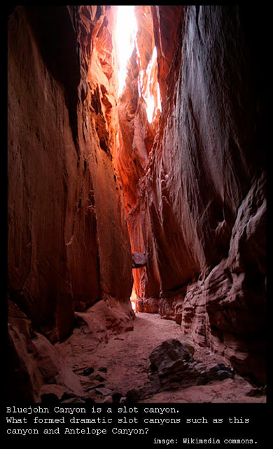
On April 26, 2003, outdoorsman Aron Ralston (then 27) was canyoneering in Bluejohn Canyon, a remote slot canyon in Utah, when a heavy boulder he had clambered over on his way down became dislodged and fell in such a way as to pin his right forearm against the canyon wall.

Having told no one exactly where he was heading (other than the somewhat general "Utah"), no one would know where to look for him if he didn't return on time. No one was coming to find him.

Thus began a gripping ordeal which is described in Mr. Ralston's own words in the book Between a Rock and a Hard Place and which is portrayed powerfully in the movie 127 Hours (2010).

If it is April 26 where you are right now on the globe, you can imagine being trapped on this day and celebrate Aron Ralston's compelling escape from his predicament five days from now, on May 1 (mark your calendar). Somewhere in those 127 hours, you might want to pick up the book and watch (or re-watch) the movie.

Not only did Mr. Ralston's perseverance and fortitude in finding a way to extricate himself (and his subsequent refusal to let the loss of his arm stop him from climbing and adventuring since then) make him justifiably famous around the world, but it also gave Bluejohn Canyon a new notoriety.

Let's take a look at the forces which might explain the existence of slot canyons, which (like so many other geological features on our planet) appear to be better explained by the catastrophic mechanisms of the hydroplate theory than by the conventional uniformitarian theories.

Slot canyons are steep-sided narrow canyons which are usually significantly deeper than they are wide (sometimes as narrow as three feet at the top but 100 feet in depth!) The most famous, perhaps, is the unmistakeable Antelope Canyon in Arizona, which (as discussed below), may well have been produced by the same forces and the same post-flood event that carved Bluejohn Canyon.


Bluejohn Canyon (see Google Maps image above) is located on the Colorado Plateau, which according to the hydroplate theory was uplifted by the sinking action of the adjacent Rocky Mountains in the catastrophic events surrounding a global flood.

If you are unfamiliar with this theory and are ready to dismiss it altogether because it proposes a global flood, don't do so until you check out the evidence presented elsewhere on this blog or in hydroplate theory originator Dr. Walt Brown's extensive online book examining worldwide geological evidence.  Most especially, check out the evidence suggesting that the Grand Canyon is better explained by this theory than by the conventional theories -- because the events surrounding the creation of the Grand Canyon are intimately connected with the events which created Antelope Canyon and Bluejohn Canyon as well, if the hydroplate theory is correct.

The dramatic events leading up to the creation of the Colorado Plateau, and the subsequent creation of the Grand Canyon and the other incredible geological features which surround it (including the slot canyons as well as petrified wood, the Goosenecks, Bryce Canyon, Monument Valley, and many other distinctive features of the American Southwest) are described by Dr. Brown on this webpage.

Essentially, he argues that when the drifting continents ground to a halt (after drifting apart during the flood in the direction of the Pacific Basin, as described in this previous post), they thickened and in some places created huge mountain ranges (almost always perpendicular to the direction the continents were moving). Floodwaters poured off the thickened continents, but in many places they were trapped in enormous inland seas or lakes (such as in California's Great Central Valley).

On the Colorado Plateau, two enormous lakes were not only trapped but elevated as the Colorado Plateau rose. When they later breached, the escaping waters carved the Grand Canyon quite rapidly -- explaining why the canyon goes right through the Kaibab Plateau (the conventional theory, of slow erosion by the Colorado River over millions of years, has a very hard time explaining why that river would choose to go over and through the Kaibab massif, or how it could have done so).

Less obvious but equally scientifically supportable, this theory argues that if these events explain the formation of the Grand Canyon, they would also explain geological features in the surrounding area that were created when sub-surface water erupted out due to the catastrophic draining of those two enormous lakes (which Dr. Brown names Grand Lake and Hopi Lake for convenience -- you can see the area that the geologic evidence suggests that they once occupied in this map).

The water table below the surface of the land surrounding these lakes was roughly at the same level as the lakes' former surface, and when the lakes suddenly drained, the surrounding water table was suddenly left next to two giant basins -- and sub-surface water began to burst out in ways that carved some of the world's most distinctive terrain features.  Later, some of that water from the land around those lakes would also erupt upwards out of the former lake-bottoms. As Dr. Brown explains:
Grand and Hopi Lakes emptied in weeks, so the water table surrounding those basins, in effect, quickly rose hundreds of feet. Perhaps several Great-Lakes’ worth of high-pressure subsurface water began seeking underground escape routes into those draining basins. Escaping groundwater exploited cracks and weak spots in the rock and opened up underground channels, many miles long. Those channels became destinations for even more escaping groundwater. The more water that flowed through these channels and their tributaries, the larger they became. In this way, hundreds of canyons formed that today enter the basins of the former Grand and Hopi Lakes. [That quotation is found on this page].
The hydrodynamic forces which created the slot canyons that are found in this general part of the world were carved by this subsurface water, according to Dr. Brown, and not by the erosive action of surface water flowing on the earth's surface (as the conventional theories propose). He explains:

Slot canyons have rough, vertical sandstone walls and can be a few hundred feet deep but only a few feet wide. They are usually found on the Colorado Plateau, along tributaries that feed into the Colorado River.73 [. . .] Conventional thinking says that slot canyons were carved by streams or flash floods eroding down from the surface. However, that would produce V-shaped canyons with relatively smooth walls, not extremely narrow, vertical canyons with jagged walls [. . .]. Besides, this quarter-mile long slot canyon, located at 36°51'46.14"N, 111°22'30.24"W, cuts through a ridge that rises 120 feet above ground. If the crack were not already there, a stream would flow along or around the ridge, not through it. Also, why would slot canyons be cut primarily through warped sandstone layers on the Colorado Plateau? Why are slot canyons not more uniformly scattered worldwide?
“Plateau Uplift” on page 208 explains why hydraulic uplifting of the Colorado Plateau warped horizontal layers and produced vertical fractures through those sedimentary layers. After Grand Lake breached, thin, vertical fractures that had penetrated wet layers of porous sand (aquifers) would have become drainage channels if flow could occur down to what would soon become the Colorado River. Drainage along those fractures eroded slot canyons and exposed warped, curved layers that were later cemented into sandstone by the silica-rich subsurface water. These vertical fractures produced slot canyons and streams; streams did not produce slot canyons. If all this happened millions of years ago, slot canyons would be much wider and shallower. [These sections of text are found on this page, at Figure 130, below photographs of Antelope Canyon].
These are very powerful points. Further support is provided by the clustering of features explained by this hypothesis in the geological region where we would expect them if in fact two huge lakes breached the way Dr. Brown believes that they did.

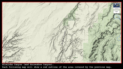
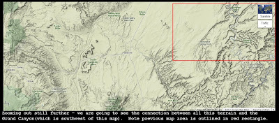
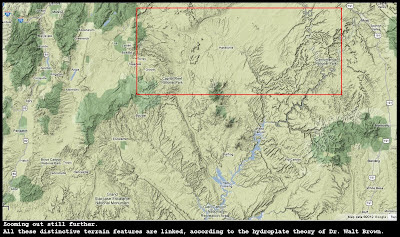
The series of maps below show how the location of Bluejohn Canyon is part of the area which would have been affected by this massive event, if the explanation proposed by Dr. Brown is correct (and there is ample evidence to suggest that it is). Note the other violently-disturbed terrain all around Bluejohn Canyon, starting with the Canyonlands and proceeding all the way to the Grand Canyon and beyond.

Each successive image "zooms out" to cover more ground, with the intent of showing how Bluejohn Canyon is part of a larger interconnected series of terrain features (including the Grand Canyon and also nearby Antelope Canyon) that were all carved by forces surrounding those breaching lakes (escaping water from the lakes, followed by violently escaping subsurface water). The area covered by the previous map is shown by a red rectangular outline in each successive map. The final map also shows the outline of the area covered by the very first map (which is the one above).


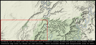
By "zooming out," this map shows how the line of canyons including Horseshoe Canyon and Bluejohn Canyon drain into Green River (northeast of the area covered in the red rectangle) -- Dr. Brown notes how many canyons (which he calls "barbed canyons") flow into rivers from the opposite direction that tributaries generally flow in regular river formations (the Green River, above, flows to the south, but the drainage of the slot canyons into it comes from the south and flows in from southwest to northeast). The explanation: these barbed canyons (including the slot canyons) were created by subsurface water flowing out into the basins that would later be occupied by the Colorado River and the Green River.


At this point we've almost zoomed out enough to see how all this terrain links together with the Grand Canyon (and many other features discussed by Dr. Brown on this page and this page of his website).


Below (at last) is a "Big Picture" image showing the location of Bluejohn Canyon in relation to the Grand Canyon, and other features that can be explained by the catastrophic draining of those two massive lakes.


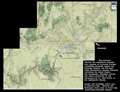
In the map above (click on the image to enlarge it) you can see a label pointing to Bluejohn Canyon (inside the smaller red rectangle, which represents the area covered by the very first map up at the top of this post), as well as labels indicating the location of the Goosenecks (explained by Dr. Brown in the caption to figure 127, about three-fourths of the way down this long page), the famous Monument Valley (the backdrop for many John Wayne movies, its origins as the former lake-bottom of Grand Lake discussed by Dr. Brown in figure 124 on the same long web page), the stunning Antelope Canyon area (caused by the same rushing subsurface flows that carved Bluejohn and Horseshoe Canyons further north), the "funnel" formation at the origin point of Marble Canyon (where water blasted out on its way to setting the conditions for the carving of the Grand Canyon), Coal Mine Mesa (discussed, along with a photograph, at figure 129 at the bottom of that same page), and of course the Grand Canyon itself.

Dr. Brown also points out a host of problems with the conventional explanation for the Grand Canyon and the surrounding features (including "barbed canyons" that run "the wrong way" as Bluejohn does) on this web page.

This is all very powerful evidence, in my opinion, and worthy of careful consideration. It suggests that slot canyons are caused by relatively rare circumstances, typically involving a trapped post-flood body of water, uplifted due to nearby mountains, and then rapid breaching of large volumes of water and subsequent subsurface flows and eruptions of the "stranded" water table. They don't only occur in the American Southwest, but a large percentage of them do. Bluejohn Canyon certainly fits the description and appears to be evidence supporting the hydroplate theory's explanation of past events.

This is not to suggest, of course, that Aron Ralston accepts the hydroplate theory or its explanation for the creation of Bluejohn Canyon. However, as people around the world think back on his courageous escape, it is worth spending some time thinking about the amazing geology of our globe -- including slot canyons such as Bluejohn Canyon -- and how best to explain the evidence that we find to this day.


Ogham inscriptions in Colorado


In 1975, historian Dr. Donald G. Rickey (1925 - 2000) was investigating the site of an 1868 battle which took place between soldiers of the 7th US Cavalry and a raiding party of Cheyenne warriors at Hackberry Springs, in Colorado.

At the time, Dr. Rickey was the Chief Historian for the Bureau of Land Management (part of the US Department of the Interior), and had a personal interest in the battle in that one of the two 7th Cavalry troopers killed in the battle was his ancestor Sam Rickey.

While at the site, Dr. Rickey discovered groove marks which he initially called "spear-sharpening marks." However, as circumstance would have it, he traveled to Scotland only a few weeks later, where he happened to visit a museum displaying the distinctive grooved writing system known as Ogham or Ogam, used by the Celts and found in throughout the British Isles, mainly in Ireland but also in England, Wales and Scotland, almost always in the form of grooves carved into stones.

He immediately suspected that the rock inscriptions he had seen in southern Colorado might be an example of this same writing system. Dr. Rickey returned to the site with other researchers over the next two years, and eventually contacted Dr. Barry Fell (1917 - 1994), a Harvard professor and the author of the controversial America BC, first published in 1976. Professor Fell agreed that the inscriptions were likely an example of Ogham, and of the older "all-consonant" variety which seems to prevail in the Americas.

Dr. Rickey submitted the site for consideration for recognition of its historic significance, but his mention of the possibility that the rock art might be Ogham elicited a swift and contemptuous response from his archaeological colleagues, as described in the short video clip above. The full text of the memos and letters between the defenders of the orthodox view of history (which does not admit to the possibility of ancient trans-oceanic travel) can be seen here.

The tone of these letters is revealing. Dr. Stuart Piggott of the University of Edinburgh (to whom the Chief Archaeologist of the National Park Service wrote upon learning of Dr. Rickey's heretical suggestion) wrote back to say "I have just heard of this and have no doubt that it is not just the fringe but hard-core lunacy. I am astonished that anyone, particularly a historian, should have fallen for it" (see page 3 of the online pdf linked above; that pdf also contains a photograph of the inscriptions on page 6).

Unfortunately, this type of refusal to consider the evidence typifies so much of the academic response to the suggestion that some of their foundational assumptions might not match the evidence.

There is extensive evidence of Ogham writing in the Americas. One excellent book detailing Ogham inscriptions in the Colorado region (and surrounding areas, where ancient waterways might have led trans-Atlantic voyagers as seen in this video) is the Colorado Ogam Album, by Donald L. Cyr (1994). That volume contains one hundred eighty high-quality photographs of such inscriptions from an area of about two hundred miles in diameter. Donald Cyr published a discussion of these important New World inscriptions in 1997 in Atlantis Rising (article here).

As this blog has pointed out many times before, the alleged Ogham inscriptions (and evidence of other Old World writing systems appearing in the New World, such as the Micmac hieroglyphs) are by no means the only "data point" which points to the conclusion that mankind's ancient history is radically different from what is being taught in universities (and defended with such smugness by professors such as the professor quoted above). For a list of other forms of evidence (with links to discussions of each), see this previous post. And that list is by no means exhaustive, either.

Sadly, the refusal of the conventional academic and archaeological community to countenance the possibility that these inscriptions might be important clues to a more accurate understanding of the ancient past acts to prevent their study and preservation, and strongly discourages large numbers of academics with expertise in Ogham from hazarding a translation of any of them, for fear that they will be branded a "hard-core lunatic" (or worse).


April Lyrid meteor shower for 2012, what causes it, and how to see it


The April Lyrid meteor shower takes place each year as the earth reaches the portion of its orbit designated by the dates April 20 through 26. This meteor shower is the product of the dust trail left by the long-period Comet Thatcher (C/1861 G1). The earth reaches the heaviest part of the residue cloud on April 21 or 22 each year, and this year it should be on April 21. Since these meteors can generally only be seen at night, the night of April 21 is probably the best night to see the shower, so make your plans now!

Here is a previous post featuring a rough sketch I drew to help illustrate the connection between the paths of comets traveling through the inner solar system and the meteor showers that are associated with different nights of the year. That diagram shows the meteor showers created by the debris from Comet Halley, the October Orionids and the Eta Aquariids (which take place around May 4). Here is a link to a helpful web page listing the meteor showers of the year.

Note that Comet Halley in the diagram can be seen to approach the inner solar system and earth's orbit from "below" the ecliptic plane (the south-pole-side of the plane of the ecliptic), and then break above the plane for a short time before diving back down on its way out. This diagram shows the plane of Halley's Comet more clearly.

In contrast, the image above from NASA's Jet Propulsion Laboratory shows that Comet Thatcher spends most of its time "above" the ecliptic plane (on the north-pole-side, that is) and dives in from a fairly steep angle. In these diagrams, the path of the comet is light blue when it is above the ecliptic plane of the earth, and darker blue when it is below it.

The image also clearly shows another striking aspect of Comet Thatcher: it is a long-period comet, with an aphelion over 110 astronomical units from the sun (an astronomical unit or AU is a unit of measurement corresponding to the mean earth-sun distance). In contrast, Halley's Comet is a short-period comet, with an aphelion of only 35.1 AU. Comet Thatcher only comes by every 415 years or so, while Halley's Comet appears every 75 or so years.

The images below show Comet Thatcher's path from a closer and closer vantage point (to give a full appreciation for the amazing orbit of this far-traveling space object: after you stare at those for a few minutes to let it really sink in, we can go on to discuss the meteor shower that its trail causes each year):


As the earth passes through the line marked on the images above representing the path of Comet Thatcher, the debris left by the comet causes the April Lyrid meteor shower (you can see why Comet Thatcher only causes one meteor shower each year, while Halley's Comet causes two if you compare the third image above with the image of Comet Halley's orbital path).

This post from last year describing a different meteor shower (the June Lyrids, which also appear to radiate from the region of the constellation Lyra, but which are caused by a completely different comet trail and are not as strong as the April Lyrids nor as anciently attested) gives a mental image you can use to explain the predictable meteor showers of the year to your friends (it is also a helpful mental construct for understanding the important phenomenon of precession, as discussed in this post and in greater detail in the Mathisen Corollary book).

As that post from last year's June Lyrids explains, meteor showers are named for the constellation from which they appear to radiate (they may be seen all over the sky, but they will seem to be coming from a certain point called the radian, and their tails will generally appear to point back towards the radian). Meteor showers named Lyrids feature meteors which appear to streak away from a point in the constellation Lyra the Lyre. This diagram of the night sky for the early morning hours of April 22 gives a good depiction of that concept.

The Lyre is a small but easily-identified constellation, because it contains the star Vega, the fifth-brightest in the sky. Also, for viewers in the most heavily-populated regions of the northern hemisphere, Lyra is visible every night of the year (although sometimes only during the post-midnight hours when most people are fast asleep). For observers in San Luis Obispo, California (W120°39'36.0", N35°16'48.0") on the night of April 21, 2012, the bright star Vega rises at 9:14 pm (and about four minutes earlier each night after that). For New Paltz, New York (W 74°04'48.0", N41°44'24.0"), Vega rises at 10:23 pm on the night of April 21 (and about four minutes earlier each night after that).

Vega is one of the three stars of the brilliant Summer Triangle, discussed in this previous post. That post features several diagrams to help you locate Vega and the Lyre (in conjunction with the Swan and the Eagle and the Milky Way).  You can also use the interactive sky chart available at Sky & Telescope which enables you to enter different locations and times and view the sky and constellations for those different places and times (you can get to that by starting at this Sky & Telescope article about this month's Lyrids).

Because the moon will be at New Moon on April 21 (between the earth and the sun and hence out of the sky during the night), it should be an ideal night to try to observe the Lyrid meteor shower.

In fact, the conditions are good enough that NASA scientists will be attempting to photograph some of the meteors from the International Space Station, and simultaneously from locations on the earth (which may enable them to create a "3-D view" of the meteor if they can catch one from two directions at once). This article from NASA's Science News page has some helpful advice from NASA scientist Bill Cooke, head of NASA's Meteoroid Science Office, who will be staying up all night on April 21-22 to chat with the general public about the shower at this URL (thanks to the astute Mr. Mark D. S. for alerting me to this!).

Here's hoping that this year's April Lyrids are a positive and memorable event for all observers. As you observe a few of the meteors, think about their origin in that lonely ball of ice orbiting far, far beyond Pluto right now (see top diagram). If you want to learn more about the difference between long-period and short-period comets, and the possibility that this bi-modal distribution of comets may support the hydroplate theory of Dr. Walt Brown, check out this and other previous posts about comets.