New study on human-induced seismic activity due to fracking wastewater injection


A brand-new study published in the journal Science entitled "Injection-Induced Earthquakes" by William Ellsworth of the US Geological Survey's Earthquake Science Center in California has concluded that deep wastewater injection wells may have played a role in the increase of earthquakes in the central US during the years 2011 and 2012.

The high volumes of wastewater being injected deep underground in these disposal wells are a by-product of the process of hydraulic fracturing, or "fracking."  While the injection of this wastewater had previously been suspected as a possible cause of human-induced seismic activity, no study had yet concluded with a high degree of certainty that this injection was actually causing the increased seismic activity.  The newly-published study concludes that there is a connection between the injection of large volumes of wastewater from fracking and the increase of seismic activity, including earthquakes measuring over 3.0.

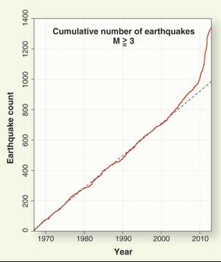
The study includes a graph showing the cumulative count of earthquakes with magnitudes of 3.0 or greater in the US "midcontinent."  The cumulative count increases steadily from 1970 through 2000 and then jumps in 2001 and increases at a more rapid pace from 2001 to the present -- an increased rate that coincides with the advent of aggressive hydraulic fracturing in the mid-continental US.


The study concludes that the fracking itself, long known to induce minor earthquakes that usually measure below 3.0, is not the probable cause of the increased number of magnitude 3.0+ earthquakes, but the practice of injecting wastewater from fracking operations into deep disposal wells is probably a contributing factor.  A quotation from the structured abstract of the study explains:

More than 100,000 wells have been subjected to fracking in recent years, and the largest induced earthquake was magnitude 3.6, which is too small to pose a serious risk. Yet, wastewater disposal by injection into deep wells poses a higher risk, because this practice can induce larger earthquakes. For example, several of the largest earthquakes in the U.S. midcontinent in 2011 and 2012 may have been triggered by nearby disposal wells. The largest of these was a magnitude 5.6 event in central Oklahoma that destroyed 14 homes and injured two people. The mechanism responsible for inducing these events appears to be the well-understood process of weakening a preexisting fault by elevating the fluid pressure. However, only a small fraction of the more than 30,000 wastewater disposal wells appears to be problematic—typically those that dispose of very large volumes of water and/or communicate pressure perturbations directly into basement faults. 
Again, although this connection had been suspected previously, it had not been studied enough for scientists in the US government to conclusively admit to a connection.  In fact, this statement from the Secretary of the US Department of the Interior (which includes the USGS) published on 04/11/2012 concludes by saying in the penultimate paragraph: "Although we cannot eliminate the possibility, there have been no conclusive examples linking wastewater injection activity to triggering of large, major earthquakes even when located near a known fault."  We can assume that the Department of the Interior will issue a new statement now that further study has demonstrated more evidence of a conclusive connection.

The process by which the injection of wastewater into the ground can trigger earthquakes is illustrated in the video above, as well as in the animated gif at the bottom of this article in Mother Jones magazine discussing the newly-published study.

The process is also discussed in some detail in a blog post that was published here on 04/11/2012 (the same date as the date of publication for the Department of the Interior statement referenced above).  The reason that post was published on the same day that the Department of the Interior chose to release a statement is the fact that at that time Bill Ellsworth, the author of this most-recent study, was beginning to suggest that the rise in seismic activity shown in the graph above may have been connected to the process of wastewater injection.  The blog post explains that this conclusion is perfectly aligned with the hydroplate theory of Dr. Walt Brown, and that Dr. Brown has in fact long predicted that the injection of water deep underground could trigger earthquakes (see for instance note 69 on this page of his book's online version -- published physical versions of his book have contained similar warnings for years prior to 2011).

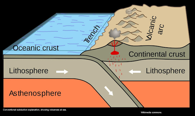
As that post also explains, the presence and direction of the numerous faults found all over the earth, including in the middle of plates, is not well explained by the existing tectonic theory but is explained by the hydroplate theory.  He notes that the faults and fracture zones on the earth (including on the floor of the Atlantic Ocean) do not conform to the explanation that they were caused over millions of years by tectonic movement, because they are sometimes many degrees out of parallel, sometimes curved, and sometimes even intersect one another (see for example his discussion on this page).

The hydroplate theory proposes that faults and fracture zones were the result of the tremendous mass imbalances in the earth during the events surrounding a global flood, which included the dramatic rise of the basement mantle under what is today the Atlantic Ocean when the escaping water eroded overlying crust and removed the weight of that crust, followed by an even more dramatic collapse of the area that now form the basin of the Pacific Ocean and Indian Ocean, as mass moved towards the Atlantic, accompanied by tremendous friction, melting, and magma production.  Thus, the very faults themselves which are discussed in this most-recent study of the possible connection between wastewater injection and earthquakes are important pieces of geological evidence which support the hydroplate theory's explanation of earth's geology.

Note that the connection between earthquakes and wastewater injection does not mean that all earthquakes in the center of plates, far from plate boundaries, are the product of human-induced activity.  Numerous previous posts have discussed the reasons that earthquakes can take place far from plate boundaries -- a phenomenon that the hydroplate theory explains quite satisfactorily, but one that the tectonic theory has some difficulty with.  Powerful earthquakes far from plate boundaries have been reported in previous centuries (such as the powerful New Madrid earthquake in Missouri in 1811), when no fracking was taking place, and earthquakes have been measured far from plate boundaries in the middle of Antarctica where no fracking operations are being conducted (as far as we know).

The editor's summary of this most-recent study also notes that the deep fluid injection of wastewater near faults may trigger earthquakes when powerful seismic waves from far-off earthquakes reach the faults in question.  Unfortunately, the hydroplate theory's explanation of earthquakes appears to support the likelihood that the number of such earthquakes may increase in the future.  This possibility is discussed at the end of this previous post which goes into more detail on the mechanisms that cause "deep earthquakes."

The study of earthquakes is very important, and the hydroplate theory's explanation of the cause of faults and earthquakes appears in many ways to be superior to the conventional tectonic models that most scientists are using today as the foundation for their understanding of these phenomena.  This most-recent study appears to be yet another example of research that confirms assertions that Dr. Walt Brown has been making for years based on his hydroplate theory.

Pacific volcanoes and the problems with the plate tectonic theory


Above is a diagram of the conventional tectonic view of "subduction" -- the action of one plate supposedly diving beneath another plate.  This diagram can be found on Wikimedia commons, and there are many more like it which all show roughly the same concept.

According to the conventional view, when one plate runs into another, it will sometimes dive beneath the other plate, creating a trench (marked in the diagram above) along the line of subduction.  Additionally, the conventional theory asserts that the diving or subducting plate is subjected to intense heat and pressure, which often causes it to melt as it dives deeper and deeper, turning into magma which then works its way towards the surface and creates a chain of volcanoes (these are also shown in the diagram above). 

Note that these volcanoes, according to the conventional theory, should be located on the side of the trench belonging to the plate that is not diving.  The magma is coming up from the melting of the front edge of the subducting plate, which is now underneath the non-diving plate (the edge of the diving plate is now on the far side of the trench from its plate, and as it melts its magma bubbles upward on the side of the non-diving plate).  

In other words, in the diagram above, we see a subducting plate coming from the left, and a non-diving plate on the right.  The volcanoes should form on the right of the trench, in the plate on the right, but they are the product of the front edge of the plate coming from the left.  The front edge of the left plate, which is subducting and is now under the right plate, creates the magma that forms the volcanoes.

Below is another diagram showing almost the same process, but this time instead of taking place near a coast, it is taking place at sea and the volcanoes are forming on the ocean floor instead of on the continent.


Again, this diagram comes from Wikimedia commons, and again there are many other variations on this diagram that one can find on the internet, all illustrating the same general concept.  

Most people learn these fundamentals of the conventional plate tectonic theory in school, and the explanation sounds fairly reasonable.  However, there are many reasons to challenge this basic explanation for the formation of ocean trenches, and to question the very existence of such a process as "subduction."  

Dr. Walt Brown, the originator of the hydroplate theory, has challenged this conventional explanation and provided numerous examples of evidence which argues against this explanation.  He discusses these reasons in depth, along with his alternative explanation for the evidence, in this chapter of his book on the hydroplate theory, which is available online in its entirety (and available for purchase from Dr. Brown and other book-sale channels).  In fact, he lists seventeen reasons that subduction is an extremely questionable explanation for the evidence that we actually find in the deep oceans, where most of the supposed subduction zones are located on our planet.

Some of the problems with the subduction theory of tectonics have been addressed in previous blog posts, such as this one, this one and this one.  Another problem with the tectonic explanation that has not been addressed directly on this blog before is the existence of volcanoes on the Pacific floor that do not appear to fit the theory -- or the diagrams above -- at all.

As Dr. Brown writes in his book, 
On the western Pacific floor are 40,000 volcanoes taller than 1 kilometer.  They lie among trenches, not on only one side of trenches. [. . .]  If subducting plates generate magma that forms volcanoes, then volcanoes should lie on the side of the trench above the descending plate.  [See Figure 85 on page 150].  Actually, most volcanoes in the western Pacific lie on the opposite side of trenches.  Also most volcanoes in the western Pacific are interior to a plate -- contradicting plate tectonics, which says volcanoes should usually form near plate boundaries.  
The above quotation comes from pages 154-155 of his 8th edition, and can also be found online about a third of the way down this webpage, under the heading "Scattered volcanoes."

Below is an image from Google maps showing the southwestern area of the Pacific ocean floor.  You can see for yourself the volcanoes which Dr. Brown is discussing in the quotation above, and consider whether the plate tectonic explanation is a good one for the evidence that we actually find, and whether the reality looks anything like the subduction diagrams shown above:


In the map, you can clearly see trenches toward the west (left) side of the image -- some of the deepest ocean trenches on our planet, in fact.  The conventional view is that the plate to the right is subducting under the plate to the left to create these trenches, although how it makes those arcs and cusps is another huge problem with the tectonic theory.  However, more to the point of the volcano-location discussion, notice all the volcanoes scattered across the floor of the Pacific to the right of the trenches, some of them extremely far away from any supposed "subducting" activity.  The Hawaiian Island chain is one series of volcanoes in the image, but there are many others that you can see, none of which look like they support the subduction description of events at all.

Dr. Brown believes that the magma that created these volcanoes does not come from a subducting plate -- the magma came from the catastrophic events surrounding a past global flood on our planet.  According to his theory, the entire floor of the Pacific was pulled towards the center of the earth by the physics involved in the flood event.  When this happened, the intense shearing and heat generated magma around the entire edge of the subsidence -- a ring of magma known today as the "Ring of Fire."  The same forces also "depressed, cracked, and distorted the entire western Pacific.  Frictional melting produced large volumes of magma that spilled out on top of the Pacific plate.  Some of that magma formed volcanoes" (154).

This explanation does a much better job of accounting for all the evidence that we actually find in the Pacific.  The tectonic theory, while better than what came before it, has enormous problems.  The "subduction" explanation is one major problem with the tectonic theory, but it is not alone.  Scientists should overcome their aversion to "catastrophic" explanations and consider the hydroplate theory of Dr. Walt Brown, which provides very comprehensive and satisfactory explanations for the evidence we find on our amazing planet Earth.

Utterance 245: transformation into a hawk


Above is an image from Wikimedia commons of an Olmec figurine, discovered in what is now Mexico, and thought to date from the 6th century BC to as far back as the 10th century BC.  It is made of greenstone, which is a material that is notably treasured by the Maori of Aotearoa and used by them for centuries to make figurines and jewelry, as discussed in this previous post.  

This particular Olmec figurine displays features of a man, but also of a bird of prey, possibly an eagle, including a plume between two wide-spread eyes, and a beak-like mouth.  Here is a link to the page at the Metropolitan Museum of Art describing the figurine.  The discussion there notes that some scholars believe that:
such figures are representations of a shaman's transfiguration into his nahual, or powerful animal counterpart. It is believed that, in this altered state, a shaman is able to interact with the spirit world and use his abilities to heal, punish, or predict the future.
In the Pyramid Texts of ancient Egypt, the king is described as transforming into a bird of prey as well.  Scholar Jeremy Naydler has argued that the Pyramid Texts do not describe the hoped-for journey of the soul of a departed king, but rather that they describe a deliberate out-of-body journey taken by a living king.  In other words, he believes the Pyramid Texts are primarily shamanic rather than funerary.  See this previous post and this previous post for further discussion of Jeremy Naydler's important thesis.

You can visit the Pyramid Texts online through an outstanding website called the Pyramid Texts Online.  There, you can read the texts as they are laid out in the pyramid of Unas, last king of the Fifth Dynasty of ancient Egypt, whose reign ended circa 2345 BC.  On the south wall of the passageway between the sarcophagus chamber and the antechamber, you can find Utterance 245, in which Unas is transformed into a hawk:
This Unas comes to you, O Nut,
this Unas comes to you, O Nut!
He has thrown his father down to earth
he has left a Horus behind him.
His two wings have grown as those of a hawk,
(his) two feathers (are those) of a holy hawk.
His soul has brought him (here),
his magical power has adorned him.

May you open your place in heaven amongst the stars of heaven!
You are indeed the unique star, the comrade of Hu.
May you look down on Osiris, when he gives orders to the spirits!
You stand high up, far from him.
You are not of them, you shall not be of them. 

Do your own due diligence: Geoengineering


Here is a topic which positively begs for due diligence.  The phrase "due diligence" is shorthand for the following general idea: On subjects that could seriously impact your life, you should take the time to look into those subjects yourself, rather than simply taking someone else's word for it.

For example, if someone comes up to you and asks you to invest what to you would be a substantial sum of money in some business venture that they have heard about, you should probably conduct some of your own "due diligence" rather than simply basing your decision on hearsay. 

The above video makes assertions which, if true, could seriously impact people's lives in a very negative way.  The assertions are so serious, in fact, that it is worth taking the time to watch the entire presentation.

The video presents substantial evidence to support its assertions.  It is, of course, possible that for some reason the video is presenting false information, made to sound plausible through the creation of false charts, photographs, and other deception.  While it is difficult to imagine a motive for creating such a deception, it is certainly possible.  Readers are encouraged to watch the video, and then look into the issue for themselves. 

Some websites have emerged to "debunk" the information in the above video.  Here is one list of counterpoints offered by critics of the above assertions.  Many of the arguments on that page appear to be challenging technical details of some of the assertions made in the video regarding impacts and effects, while ignoring the bigger question of whether deliberate geoengineering is actually underway.  If deliberate geoengineering is actually being conducted, and being conducted without the knowledge of the populations being exposed to that activity, that would seem to be the bigger issue.  That question should be addressed, rather than haggling over whether or not some of the compounds allegedly being used for such geoengineering are harmful or not.

Elsewhere, the same "debunkers" actually do appear to argue that deliberate geoengineering is not taking place, saying that aerial spraying is a myth and blaming "ship trails" caused by ocean-going vessels for the cloud patterns discussed in the above video.  Again, this is a very important topic, and readers should examine competing explanations for themselves and decide which proposed explanations best fit the evidence at hand.  

If in fact no deliberate geoengineering is taking place, then perhaps there is no cause for concern in that area.  On the other hand, if deliberate geoengineering is taking place without informing the human beings who are potentially impacted by that activity, then there are potentially enormous ramifications.  Because the potential ramifications are so severe, everyone should take the time to investigate this issue for himself or herself.  The video above is a good place to start, followed by the counter-arguments presented in the pages linked above (and elsewhere on the internet).  

After that, the documents library at the Geoengineering Watch website presents numerous papers published over the years relating to this subject.  A visit to that library to read some of those documents would certainly seem to be in order.  After all, prior to making a monetary investment in an company, it is advisable to spend at least as much time as the above research would take, examining the financial statements and other filings and materials related to that company prior to investing money in it.  That's because "due diligence" is called for regarding subjects that could seriously impact one's life (such as the potential loss of money from a careless investment).  It would seem that the subject discussed above is deserving of at least that much due diligence, and possibly more. 


Immature dinosaur fossil from the Alaskan Arctic further evidence for earth's "Big Roll"


Another special thank-you goes out to Mr. TRB of California, who noticed this story entitled "Juvenile Dinosaur Found in Alaskan Arctic" and immediately realized the importance of such a find to the subjects regularly discussed on this blog.

The article reports the recent discovery of a skull believed to belong to an immature pachyrhinosaurus, a plant-eating dinosaur of the Ceratopsidae family of horn-shaped dinosaurs (other members of this family include Styracosaurus, Monoclonius, and the famous Triceratops).

The full research article about the find was published on June 19th of this year in the journal PLOS One, and is entitled "An Immature Pachyrhinosaurus perotorum (Dinosauria: Ceratopsidae) Nasal Reveals Unexpected Complexity of Craniofacial Ontogeny and Integument in Pachyrhinosaurus," by Anthony R. Fiorillo and Ronald S. Tykoski. 

As shown in the map above, the fossil discussed was discovered well north of the Arctic Circle, in northern Alaska south of Prudhoe Bay, in the vicinity of the Kikak-Tegoseak Dinosaur Quarry.  Numerous other fossils have been found in this same quarry in the past -- including a tyrannosaur, other pachyrhinosaurs, and even insects, according to this list from the Smithsonian's ETE (evolution of terrestrial ecosystems) paleobiology website.

The discovery of so many dinosaur fossils in a quarry so far north of the Arctic circle is remarkable in and of itself, and raises questions as to how they found food to sustain their massive bulk so far to the north, especially the plant-eaters such as Pachyrhinosaurus.  Scientists generally believed that dinosaurs ranging so far were probably migratory adults, who would head back south during the long, cold, Arctic winter (above the Arctic circle, there are days during the winter in which the sun never emerges above the horizon). However, this newly-discovered skull of a young Pachyrhinosaurus in the same formation appears to upend that theory, causing scientists to conclude that the dinosaurs perhaps lived there year-round, and even had offspring there.

Here is a description of the region from the original research article announcing and discussing the find:
The Kikak-Tegoseak Quarry is a monodominant bonebed deposit [13] with a minimum of eleven individuals represented in the quarry, based upon the number of occipital condyles currently known from the site (including that in the nearly complete skull DMNH 22558). The specimen was collected as a float block found within a meter of the main Kikak-Tegoseak Quarry edge. We are confident that the new specimen can be referred to P. perotorum and that it does not represent a second ceratopsid taxon from the site. The specimen is notable because it comes from a smaller, relatively immature individual, contrary to previous published statements about the individuals from the quarry all being of similar ‘adult’ ontogenetic stage [13] and therefore expands the known age profile of this taxon from the site.
As discussed in previous posts, the discovery of any fossils at all, anywhere on the planet, should raise questions as to how those bones were preserved and petrified, because under normal conditions the bones of animals that die in the wild are decomposed by microbes and other factors long before they can turn to stone.  Special conditions, such as rapid burial under thick mud, are probably required for the creation of most fossils.  The fact that there are so many fossils around the world points to the possibility of some sort of cataclysm or cataclysms that created such special conditions in the ancient past.  

Further, this fossil bed contains numerous fossils of the same species, as well as of a few other species, as mentioned in the article and in the list of taxa linked previously.  Could this concentration of fossils represent numerous individuals who fell victim to a single catastrophic event?  

Finally, the fact that these fossils are found so far to the north -- and include the remains of an immature Pachyrhinosaurus -- is perhaps the most puzzling aspect of all.  Are we really to believe that these were all representatives of a species of "polar dinosaur," who spent their year at such extreme northern latitudes, near the northern coast of Alaska, and even bore their young there?  These are reptiles, not warm-blooded caribou.

All of the difficult problems listed above, however, are explained by the hydroplate theory of Dr. Walt Brown.  That theory proposes that there is substantial evidence to support the possibility that a catastrophic world-wide flood once erupted with great violence and covered the earth, accompanied by massive amounts of sediments which would have rapidly buried and fossilized many animals and plants.  

Even more importantly for the understanding of how so many seemingly incongruous fossils are found at latitudes so far to the north (and so far to the south as well), Dr. Brown's theory discusses why the principles of physics would have caused the entire earth to undergo a "Big Roll" in the aftermath of that flood event, a roll which would have brought latitudes that were formerly further south "up" towards the Arctic, as well as (on the other side of the earth) latitudes that were formerly in more temperate climates "down" into the Antarctic as well.  

You can envision this event by taking a basketball between two hands and looking down at it, imagining that the point on the ball that you are looking down on represents the north pole, and then rotating the ball forwards using the rotation of both of your wrists -- bringing "latitudes" on the ball that were formerly further south up into the "north pole" area that you are looking at from above.  Acknowledgement goes out to Rand Flem-Ath for this basketball metaphor, which he used in an interview in 2009 (for the record, this mention is not intended to suggest that Mr. Flem-Ath supports the hydroplate theory; he appears to believe something different, although he also believes that the conventional theories generally taught as undisputed fact have serious problems and probably are not correct).

Of course, when you rolled that basketball, you moved a lot of fossils that had been buried at more temperate latitudes on the ball up towards the "Arctic" part of the ball, and on the other side you rolled fossils from more temperate latitudes down towards the "Antarctic" part of the ball.  So, those animals did not need to actually live in those latitudes before they were buried and before the earth experienced its "Big Roll."  According to Dr. Brown's theory, events that took place after the rapid burial of plants and animals led to the physics that caused the roll of the earth.

Previous posts have discussed the many fossil findings which have surfaced over the years in both the Arctic and the Antarctic that support the idea of a "Big Roll."  These include:
This discovery of the immature Pachyrhinosaurus would appear to join this list of evidence pointing to the earth's Big Roll at some point in the ancient past (and there are other pieces of evidence, not found in the Arctic or Antarctic, which also support the Big Roll conclusion).

More evidence for Dr. Brown's theory continues to show up around the world.

The cat's eyes in the Scorpion


This is a beautiful time of year for observing the constellation Scorpio, who is easily seen rising up from the horizon in the hours after sunset.  

Scorpio is a like gleaming string of jewels in the southern sky (for northern hemisphere viewers), with brilliant red Antares at his heart -- the constellation's brightest and most distinctive star and the largest in the chart above (marked by the Greek letter lower-case alpha, and the word "Antares").  Currently, Antares reaches its highest point on its arc at about 11 pm, and then reaches it about four minutes earlier each night as the earth continues its orbit around the sun (for more on that process, see the discussion in this previous post and the video in this one).

If you can observe Scorpio around that point of its highest elevation (also known more precisely as its transit across the meridian) or in the hours after that -- for instance, around midnight -- you will have an opportunity to see the charming pair of stars near the end of its stinger-tail, a pair of stars known as "the cat's eyes."  As Scorpio begins to arc back down towards the western horizon, the cat's eyes become nearly horizontal, and they really do look like a pair of cat's eyes, gleaming out at you in the night sky!

The cat's eyes are pointed out by the two arrows in the above chart.  They are a bit further apart in the night sky -- the chart makes them look as though they overlap, because it depicts each star as larger or smaller depending upon its brightness, and the "eye" on the left is a bit brighter than the other, so its depicted size is larger on the chart than it looks when you go out into the night.  In actual fact, they are about as far apart as . . . the eyes of a cat!

In his superlative book for star-gazers, The Stars: a New Way to See Them, author H.A. Rey writes: "Look for the CAT'S EYES, a close pair of stars in the Scorpion's tail.  You will find the name quite fitting" (52).  They are especially easy to spot on nights like tonight (and the next several nights) when the moon does not begin to rise in the east until nearly midnight, and getting later and later each night as it wanes.

Once you have located the cat's eyes, you will want to look for them again and again!  

For previous posts discussing Scorpio and how to find that constellation, see here and here.  For a previous post with an image of cat's eyes, see here.

The geology of the Little Colorado River Gorge


Over the weekend, on Sunday 06/23, aerialist Nik Wallenda crossed the Little Colorado River Gorge on a two-inch-wide steel cable, taking approximately 22 minutes to make the journey.

Many watched the event live on the Discovery Channel, which sponsored the c
rossing.  Some of the footage can be seen here at the Discovery Channel website.

Some Native tribes protested the event, arguing that the canyon is sacred to their people and should not be used for a publicity stunt.  Others assisted in the event, and the Navajo Nation provided the permit in exchange for the clean up of some platforms and cables left behind for decades after a planned crossing in the 1970s that never took place due to lack of funding (according to this article).

Whatever your opinion of that controversy, Wallenda successfully accomplished the incredible crossing over the 1,500-foot chasm.  The geology of the location is absolutely breathtaking.  It also provides important clues about our planet's past.

Below is a map showing the location of the Little Colorado River Gorge.  It empties into an area of unusual erosion called Nankoweap Canyon, near the point where it comes together with the Colorado River.  This junction of the the Colorado and Little Colorado is called the Confluence and is sacred to the Native tribes of the area as the site of the most ancient inhabitants of the region.


Both Nankoweap Canyon and the Little Colorado River Gorge are important clues to the mystery of the formation of the Grand Canyon, and they present geological evidence that confounds conventional theories.

Dr. Walt Brown, the originator of the hydroplate theory, believes the Grand Canyon was formed by events that took place in the aftermath of a global flood, and his theory provides an explanation for the Little Colorado River and Nankoweap Canyon (as well as for the very difficult-to-explain turn in the Colorado River seen in the map above, where the river that was running generally north-to-south takes a hard right turn to the west and plows right through the enormous massif of the Kaibab Plateau, which is colored green in the map).

Previous posts have detailed Dr. Brown's theory for the creation of the Grand Canyon -- see for example:
n and surrounds, see for example:
Dr. Brown believes that the mechanisms that formed the Grand Canyon and surrounding features began with two large bodies of water that were trapped after the floodwaters drained off the earth, and uplifted by the physics related to the rapid formation of the Rocky Mountains, whose weight caused them to sink downwards, forcing the Colorado Plateau upwards.  

Dr. Brown calls these two lakes "Grand Lake" (further north) and "Hopi Lake" (further south), and diagrams where they were on this map. He believes that Grand Lake eventually breached catastrophically due to increased rainfall and runoff after the flood (caused by warmer oceans). The tons of water cascading out of it eventually undermined the walls holding in Hopi Lake as well, and it breached as well.  The Little Colorado River Gorge marks the location of the breach of Hopi Lake.

About halfway down this webpage, Dr. Brown discusses Nankoweap Canyon and the evidence there which is very difficult to explain by proponents of the conventional theory for the Grand Canyon's formation.  Discussing the detailed image of the Nankoweap Canyon region shown there, he writes:
Nankoweap—Region of Unusual Erosion. This view is looking southeast from 4,400 feet above the ground. The Little Colorado River enters the southern end of Marble Canyon at the top center. The yellow line encloses a region of unusual erosion. Notice that on the top of the high Kaibab Plateau, streams do not flow into the many canyons that are cut into this southeastern portion of the Kaibab Plateau. So, what cut these side canyons, and why are they in such a localized area? Why would the terrain east of Marble Canyon, which is at least 2,000 feet below the top of the Kaibab Plateau and most of this erosion, be so smooth? On top of Nankoweap Mesa are slumps, landslides, and rockfalls. How can rocks fall and mud flow onto the top of a mesa?  
Another point of difficulty for conventional theorists is the origin of the Little Colorado Gorge in the first place.  As you can see from the map above, it seems to spring from out of the desert itself.  Dr. Brown's theory argues that subsurface water burst out of the water table after Grand Lake and Hopi Lake began to empty, and it was this subsurface water which was responsible for creating many of the major canyons that we see emptying into the Grand Canyon from the sides.  The canyons themselves, such as Marble Canyon and the Little River Gorge, are cracks created when the ground arched upwards after the catastrophic breaching of Grand Lake and Hopi Lake removed the material above.  The subsurface water then flowed out the sides of these cracks, creating the side canyons we see today, including the Little Colorado Gorge.

The fact that Nankoweap Canyon was the site of the earliest known habitation in the area is also problematic for conventional geological theories, because they have a hard time explaining where all the water came from that attracted the Old Ones or Anasazi to the area in the first place, and what caused it to disappear, causing them to leave.  This article by Terry Hurlbut discusses this question, and interestingly enough does so in light of Dr. Brown's theory, which provides a satisfactory explanation for the human history of the area.

We can all be glad that Nik Wallenda made it safely across the canyon on his first try.  His feat should cause us to examine the amazing geology of the Little Colorado River Gorge and the Grand Canyon, as well as to reflect upon the sacred traditions of the Native tribes who still remember and honor their ancestors who lived in the region so long ago -- and to consider the ways in which the geology and the human history of this beautiful area are intertwined.